TopoQuest Logo
Do you find TopoQuest useful?
Help keep TopoQuest running and adding new maps/features by donating!
Home View Maps Find Maps Find Places Resources & Links


Flora, Mississippi Topographic Map

USGS Map Title: Flora, MS
USGS Map MRC: 32090E3
DRG (GeoTIFF) Download: o32090e3.tif


Neighboring USGS Topographic Map Quads:


  Tinsley, MS  
32090F4
 

  Bentonia, MS  
32090F3
 

  Berryville, MS  
32090F2
 

  Coxs Ferry, MS  
32090E4
 

  Flora, MS  
32090E3
 

  Charlton, MS  
32090E2
 

  Brownsville, MS  
32090D4
 

  Pocahontas, MS  
32090D3
 

  Ridgeland, MS  
32090D2


Map MRC Location:

N33°
W91°
N33°
W90°
H8 H7 H6 H5 H4 H3 H2 H1
G8 G7 G6 G5 G4 G3 G2 G1
F8 F7 F6 F5 F4 F3 F2 F1
E8 E7 E6 E5 E4 E3 E2 E1
D8 D7 D6 D5 D4 D3 D2 D1
C8 C7 C6 C5 C4 C3 C2 C1
B8 B7 B6 B5 B4 B3 B2 B1
A8 A7 A6 A5 A4 A3 A2 A1
N32°
W91°
N32°
W90°

Flora, MS USGS 1:24K Topographic Map Preview:
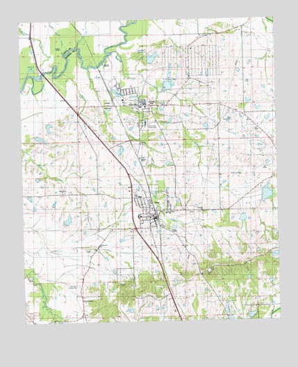
Flora, MS USGS Topographic Map
Click on map above to begin viewing in our Map Viewer.

This topographic map contains these locations and features:
Feature Name Type Latitude Longitude GNIS ID View Map
Anderson CemeteryCemeteryN32.56042°W90.26787°666256View Map
Archers IslandIslandN32.61347°W90.35315°666348View Map
Balfour CreekStreamN32.60514°W90.34176°666486View Map
Bluff CreekStreamN32.61181°W90.35315°667331View Map
Burnt Corn CreekStreamN32.61181°W90.32926°667832View Map
Burnt Corn Watershed Structure Number 3 DamDamN32.55347°W90.25342°681499View Map
Cane CreekStreamN32.59153°W90.29648°668018View Map
Church of God of ProphecyChurchN32.53986°W90.31037°705856View Map
Clark CemeteryCemeteryN32.51902°W90.29758°668508View Map
Deposit Guarnty Bank Lake DamDamN32.54014°W90.37176°681480View Map
Dodson BranchStreamN32.60319°W90.35426°669311View Map
E E Lane AirportAirportN32.58310°W90.27181°680350View Map
East Flora High SchoolSchoolN32.54514°W90.30426°705857View Map
East Flora SchoolSchoolN32.54570°W90.30481°691122View Map
Fearns ChapelChurchN32.53764°W90.30203°691123View Map
Fearns Chapel CemeteryCemeteryN32.53811°W90.30277°2042961View Map
FloraPopulated PlaceN32.54320°W90.30926°670043View Map
Flora Baptist ChurchChurchN32.54403°W90.31120°705858View Map
Flora CemeteryCemeteryN32.53930°W90.31203°2042962View Map
Flora City Police DepartmentBuildingN32.54430°W90.31079°2754194View Map
Flora Elementary SchoolSchoolN32.54347°W90.31815°705859View Map
Flora Fire DepartmentBuildingN32.54432°W90.31029°2667700View Map
Flora Post OfficePost OfficeN32.54300°W90.31119°712163View Map
Flora Public LibraryBuildingN32.54403°W90.31065°705860View Map
Flora SchoolSchoolN32.54375°W90.31870°691121View Map
Flora United Methodist ChurchChurchN32.54208°W90.30981°705861View Map
G E Morgan Lake DamDamN32.51681°W90.25342°681458View Map
Good Samaritan ChurchChurchN32.50931°W90.34620°670490View Map
Hammack CemeteryCemeteryN32.52118°W90.28127°670865View Map
Holy City Church of God in ChristChurchN32.55228°W90.31257°2501718View Map
J R Edgar Lake DamDamN32.60681°W90.30842°681530View Map
J R Edgar Lake DamDamN32.61514°W90.30009°681535View Map
Jones ChapelChurchN32.54153°W90.30815°705862View Map
Jubilee Company Lake DamDamN32.58681°W90.26176°681520View Map
Kearney Family CemeteryCemeteryN32.58299°W90.30696°2042984View Map
Kearney ParkPopulated PlaceN32.58903°W90.31537°672070View Map
Kearney Park Census Designated PlaceCensusN32.58975°W90.31581°2586600View Map
Kearney Park Industrial AreaLocaleN32.58153°W90.31398°672071View Map
Kearney Park LakeReservoirN32.59769°W90.30311°672072View Map
Kearney Park Lake DamDamN32.59681°W90.30176°681526View Map
Kendall Quinn Lake DamDamN32.57347°W90.32176°681514View Map
Kibbys Ferry (historical)CrossingN32.60347°W90.36370°683256View Map
L L Childress Lake DamDamN32.60181°W90.27509°681527View Map
Lindsey Harris Lake DamDamN32.58014°W90.28176°681516View Map
Lipscomb Family CemeteryCemeteryN32.55199°W90.30839°2042991View Map
Little Mound CreekStreamN32.61458°W90.35370°672646View Map
Madison Livestock Investment Lake DamDamN32.54681°W90.35843°681490View Map
McNamaras Ferry (historical)CrossingN32.61542°W90.32509°683257View Map
Mound BluffCliffN32.61403°W90.33065°683258View Map
Mound CreekStreamN32.60514°W90.35842°673903View Map
Mount Bluff Balfour - Gartley CemeteryCemeteryN32.57370°W90.31623°666485View Map
Mount Olympus Post Office (historical)Post OfficeN32.51959°W90.28898°712164View Map
Old River LakeLakeN32.60525°W90.36954°675236View Map
Persimmon-Burntcorn Structure 1 DamDamN32.54514°W90.26676°681486View Map
Powell - Thompson CemeteryCemeteryN32.58639°W90.31773°2043021View Map
R B Middleton Lake DamDamN32.57847°W90.25009°681515View Map
Regan (historical)LocaleN32.58347°W90.32620°707547View Map
Root Hog AirportAirportN32.51574°W90.35079°691119View Map
Simmons Memorial Baptist ChurchChurchN32.58903°W90.31815°705863View Map
Simmons Memorial ChapelChurchN32.58875°W90.31787°691125View Map
Smith ChapelChurchN32.58931°W90.33009°691124View Map
Smith Chapel CemeteryCemeteryN32.58997°W90.33091°2043038View Map
T S Rowland Lake DamDamN32.58847°W90.25509°681521View Map
Tarpley CemeteryCemeteryN32.52915°W90.34294°678572View Map
Tom Virden Lake DamDamN32.50014°W90.27009°681445View Map
Town CreekStreamN32.56486°W90.31176°678832View Map
Town of FloraCivilN32.54349°W90.31321°2406501View Map
Tri-County AcademySchoolN32.55208°W90.31815°691120View Map
Tri-County AcademySchoolN32.55181°W90.31731°705864View Map
Union Hill CemeteryCemeteryN32.54533°W90.28759°2043058View Map
Union Hill ChurchChurchN32.54514°W90.28731°679096View Map
VernonPopulated PlaceN32.58958°W90.32981°679206View Map
Vernon CemeteryCemeteryN32.58300°W90.30745°2043059View Map
W L Childress Lake DamDamN32.50347°W90.31842°681447View Map
Wilson Grove ChurchChurchN32.55375°W90.35537°679769View Map
Woodman Hill ChurchChurchN32.56764°W90.31704°679859View Map
Woodman Hill Missionary Baptist Church CemeteryCemeteryN32.56874°W90.31758°2043065View Map

Note: Coordinates in the location and feature list above are referenced to NAD83 datum.


Copyright (C) 2008-2026 Ryan Niemi / Sunset Dynamics ... All Rights Reserved
