TopoQuest Logo
Do you find TopoQuest useful?
Help keep TopoQuest running and adding new maps/features by donating!
Home View Maps Find Maps Find Places Resources & Links


Gasconade, Missouri Topographic Map

USGS Map Title: Gasconade, MO
USGS Map MRC: 38091F5
DRG (GeoTIFF) Download: o38091f5.tif


Neighboring USGS Topographic Map Quads:


  Readsville, MO  
38091G6
 

  Americus, MO  
38091G5
 

  Pinnacle Lake, MO  
38091G4
 

  Morrison, MO  
38091F6
 

  Gasconade, MO  
38091F5
 

  Hermann, MO  
38091F4
 

  Fredericksburg, MO  
38091E6
 

  Pershing, MO  
38091E5
 

  Swiss, MO  
38091E4


Map MRC Location:

N39°
W92°
N39°
W91°
H8 H7 H6 H5 H4 H3 H2 H1
G8 G7 G6 G5 G4 G3 G2 G1
F8 F7 F6 F5 F4 F3 F2 F1
E8 E7 E6 E5 E4 E3 E2 E1
D8 D7 D6 D5 D4 D3 D2 D1
C8 C7 C6 C5 C4 C3 C2 C1
B8 B7 B6 B5 B4 B3 B2 B1
A8 A7 A6 A5 A4 A3 A2 A1
N38°
W92°
N38°
W91°

Gasconade, MO USGS 1:24K Topographic Map Preview:
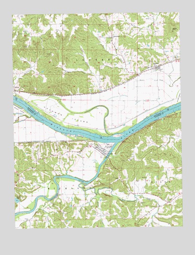
Gasconade, MO USGS Topographic Map
Click on map above to begin viewing in our Map Viewer.

This topographic map contains these locations and features:
Feature Name Type Latitude Longitude GNIS ID View Map
Baileys CreekStreamN38.69088°W91.61156°713549View Map
Best Bottom CemeteryCemeteryN38.71200°W91.56010°714007View Map
Best Bottom School (historical)SchoolN38.69893°W91.55156°744465View Map
BlufftonPopulated PlaceN38.70754°W91.62461°729443View Map
Boland KnobSummitN38.73921°W91.50628°729444View Map
Brushy ForkStreamN38.64532°W91.56350°714909View Map
City of GasconadeCivilN38.67026°W91.55993°2394867View Map
Doecher CemeteryCemeteryN38.64087°W91.51016°716948View Map
Eu-Wish AirportAirportN38.66690°W91.53651°758716View Map
First CreekStreamN38.65032°W91.57128°717932View Map
GasconadePopulated PlaceN38.66949°W91.56017°729496View Map
Gasconade City CemeteryCemeteryN38.67264°W91.56330°2702141View Map
Gasconade RiverStreamN38.67421°W91.54961°750029View Map
Gasconnade Police DepartmentBuildingN38.67139°W91.56222°2752217View Map
Gleason BranchStreamN38.71449°W91.56600°718496View Map
Government Boat YardLocaleN38.67254°W91.54850°744171View Map
Heckman IslandIslandN38.69004°W91.58656°719335View Map
Howard CreekStreamN38.64227°W91.56239°719915View Map
Libbie BranchStreamN38.63588°W91.53433°760177View Map
Lower First Creek School (historical)SchoolN38.62838°W91.51044°744172View Map
Lucas CemeteryCemeteryN38.63976°W91.59266°744170View Map
Memory LakeReservoirN38.64216°W91.62440°722227View Map
Memory Lake DamDamN38.64171°W91.62184°763876View Map
Modoc CreekStreamN38.70699°W91.50878°722509View Map
Morrison Volunteer Fire Department Station 2BuildingN38.67173°W91.56345°2621379View Map
O'Neal Dam OneDamN38.71671°W91.60350°764144View Map
O'Neal Lake OneReservoirN38.71645°W91.60293°764145View Map
Oetterer CemeteryCemeteryN38.63865°W91.53155°729591View Map
Rabenau CemeteryCemeteryN38.65336°W91.54762°725038View Map
RhinelandPopulated PlaceN38.71754°W91.51739°725240View Map
Rhineland Area Volunteer Fire DepartmentBuildingN38.71808°W91.51470°2621417View Map
Rhineland Post OfficePost OfficeN38.71989°W91.51270°2783018View Map
River ParkParkN38.66727°W91.55683°725340View Map
Saint Marcus CemeteryCemeteryN38.72254°W91.50294°725820View Map
StarkenburgPopulated PlaceN38.73588°W91.55211°741284View Map
StolpePopulated PlaceN38.64338°W91.59378°738799View Map
Stolpe Census Designated PlaceCensusN38.64437°W91.58493°2587114View Map
Sugar CreekStreamN38.64143°W91.59961°729661View Map
Town of RhinelandCivilN38.72048°W91.51759°2396876View Map
Township of RichlandCivilN38.62538°W91.59420°766661View Map
W Grimm DamDamN38.63671°W91.52350°764501View Map
W Grimm ReservoirReservoirN38.63671°W91.52350°764502View Map
Weber CemeteryCemeteryN38.65198°W91.53460°728467View Map
Wyatt Lake DamDamN38.72838°W91.57183°765279View Map

Note: Coordinates in the location and feature list above are referenced to NAD83 datum.


Copyright (C) 2008-2026 Ryan Niemi / Sunset Dynamics ... All Rights Reserved
