TopoQuest Logo
Do you find TopoQuest useful?
Help keep TopoQuest running and adding new maps/features by donating!
Home View Maps Find Maps Find Places Resources & Links


Altamont, New York Topographic Map

USGS Map Title: Altamont, NY
USGS Map MRC: 42074F1
DRG (GeoTIFF) Download: o42074f1.tif


Neighboring USGS Topographic Map Quads:


  Duanesburg, NY  
42074G2
 

  Rotterdam Junction, NY  
42074G1
 

  Schenectady, NY  
42073G8
 

  Gallupville, NY  
42074F2
 

  Altamont, NY  
42074F1
 

  Voorheesville, NY  
42073F8
 

  Rensselaerville, NY  
42074E2
 

  Westerlo, NY  
42074E1
 

  Clarksville, NY  
42073E8


Map MRC Location:

N43°
W75°
N43°
W74°
H8 H7 H6 H5 H4 H3 H2 H1
G8 G7 G6 G5 G4 G3 G2 G1
F8 F7 F6 F5 F4 F3 F2 F1
E8 E7 E6 E5 E4 E3 E2 E1
D8 D7 D6 D5 D4 D3 D2 D1
C8 C7 C6 C5 C4 C3 C2 C1
B8 B7 B6 B5 B4 B3 B2 B1
A8 A7 A6 A5 A4 A3 A2 A1
N42°
W75°
N42°
W74°

Altamont, NY USGS 1:24K Topographic Map Preview:
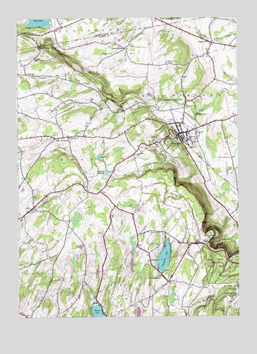
Altamont, NY USGS Topographic Map
Click on map above to begin viewing in our Map Viewer.

This topographic map contains these locations and features:
Feature Name Type Latitude Longitude GNIS ID View Map
AltamontPopulated PlaceN42.70063°W74.03374°942397View Map
Altamont Elementary SchoolSchoolN42.70035°W74.02818°968211View Map
Altamont Fire DepartmentBuildingN42.70273°W74.02496°2735165View Map
Altamont OrchardsLocaleN42.72111°W74.02139°2516825View Map
Altamont Rescue SquadBuildingN42.70429°W74.02199°2720162View Map
Altamont Rescue SquadBuildingN42.70434°W74.02202°2735166View Map
Altamont ReservoirReservoirN42.68569°W74.07424°942398View Map
Bozen Kill FallsFallsN42.73841°W74.11207°944559View Map
Camp AltamontLocaleN42.68841°W74.05096°945542View Map
Camp PinnacleLocaleN42.63397°W74.00291°945642View Map
Cobb Memorial SchoolSchoolN42.69389°W74.04639°2435635View Map
Colliton School (historical)SchoolN42.72702°W74.11957°947165View Map
Duane LakeLakeN42.74911°W74.11255°948713View Map
DunnsvillePopulated PlaceN42.73980°W74.01429°948817View Map
East TownshipPopulated PlaceN42.69980°W74.10096°949256View Map
High Point CemeteryCemeteryN42.69243°W74.05862°952754View Map
Horseshoe LotBendN42.65841°W74.01735°953242View Map
Indian LadderCliffN42.65619°W74.01652°953668View Map
KnoxPopulated PlaceN42.67119°W74.11568°954792View Map
Knox Fire District 16 Station 1BuildingN42.66947°W74.11911°2735169View Map
Knox Fire District 16 Station 2BuildingN42.70022°W74.09548°2734965View Map
Lainhart CemeteryCemeteryN42.72549°W74.03103°954891View Map
Lasalette SeminarySchoolN42.69869°W74.04402°955063View Map
Mine Lot FallsFallsN42.65341°W74.01318°957388View Map
Noch Fiernan FarmLocaleN42.74861°W74.06806°2516823View Map
Ostrander CemeteryCemeteryN42.73337°W74.11559°959521View Map
Rolling AcresLocaleN42.72889°W74.01444°2516867View Map
School Number 12 (historical)SchoolN42.71341°W74.07818°975029View Map
School Number 13 (historical)SchoolN42.66813°W74.05985°975056View Map
School Number 2 (historical)SchoolN42.70035°W74.09513°975182View Map
School Number 2 (historical)SchoolN42.73889°W74.01500°2095812View Map
School Number 5 (historical)SchoolN42.66008°W74.04485°975406View Map
Settles HillSummitN42.73619°W74.06763°964856View Map
Settles Hill School (historical)SchoolN42.73730°W74.06457°964857View Map
Severson CemeteryCemeteryN42.70187°W74.02283°964878View Map
Snyder CemeteryCemeteryN42.72567°W74.11212°965593View Map
Thacher State ParkParkN42.64924°W74.00513°967189View Map
Thompsons LakeLakeN42.64941°W74.04220°967423View Map
Thompsons LakePopulated PlaceN42.64286°W74.04402°967424View Map
Town of KnoxCivilN42.68224°W74.11068°979122View Map
Vanderpool CemeteryCemeteryN42.73137°W74.03951°968459View Map
Village of AltamontCivilN42.70499°W74.03397°2391511View Map
Warner LakeLakeN42.62509°W74.07917°968809View Map
WMHT-FM (Schenectady)TowerN42.63702°W74.00124°978602View Map
WMHT-TV (Schenectady)TowerN42.63702°W74.00124°978645View Map
WMHX-TV (Schenectady)TowerN42.62702°W74.01068°978644View Map
Wolf CreekStreamN42.72508°W74.07846°971542View Map
WPYX-FM (Albany)TowerN42.63591°W74.00096°978485View Map
WSHZ-FM (Rotterdam)TowerN42.74535°W74.06902°978598View Map
WVCR-FM (Loudonville)TowerN42.63702°W74.00124°978539View Map

Note: Coordinates in the location and feature list above are referenced to NAD83 datum.


Copyright (C) 2008-2026 Ryan Niemi / Sunset Dynamics ... All Rights Reserved
