TopoQuest Logo
Do you find TopoQuest useful?
Help keep TopoQuest running and adding new maps/features by donating!
Home View Maps Find Maps Find Places Resources & Links


Laurelville, Ohio Topographic Map

USGS Map Title: Laurelville, OH
USGS Map MRC: 39082D6
DRG (GeoTIFF) Download: o39082d6.tif


Neighboring USGS Topographic Map Quads:


  Stoutsville, OH  
39082E7
 

  Clearport, OH  
39082E6
 

  Rockbridge, OH  
39082E5
 

  Hallsville, OH  
39082D7
 

  Laurelville, OH  
39082D6
 

  South Bloomingville, OH  
39082D5
 

  Londonderry, OH  
39082C7
 

  Ratcliffburg, OH  
39082C6
 

  Allensville, OH  
39082C5


Map MRC Location:

N40°
W83°
N40°
W82°
H8 H7 H6 H5 H4 H3 H2 H1
G8 G7 G6 G5 G4 G3 G2 G1
F8 F7 F6 F5 F4 F3 F2 F1
E8 E7 E6 E5 E4 E3 E2 E1
D8 D7 D6 D5 D4 D3 D2 D1
C8 C7 C6 C5 C4 C3 C2 C1
B8 B7 B6 B5 B4 B3 B2 B1
A8 A7 A6 A5 A4 A3 A2 A1
N39°
W83°
N39°
W82°

Laurelville, OH USGS 1:24K Topographic Map Preview:
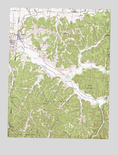
Laurelville, OH USGS Topographic Map
Click on map above to begin viewing in our Map Viewer.

This topographic map contains these locations and features:
Feature Name Type Latitude Longitude GNIS ID View Map
AdelphiPopulated PlaceN39.46673°W82.74711°1064300View Map
Adelphi CemeteryCemeteryN39.46451°W82.74850°1963449View Map
Adelphi Volunteer Fire and Rescue DepartmentBuildingN39.46785°W82.74914°2549646View Map
Adelphia Post OfficePost OfficeN39.46729°W82.74767°2056624View Map
ApplePopulated PlaceN39.40284°W82.70711°1062631View Map
Apple Post Office (historical)Post OfficeN39.40284°W82.70683°2009806View Map
Belleview CemeteryCemeteryN39.46729°W82.74350°1963453View Map
Berry CemeteryCemeteryN39.41414°W82.63137°1037876View Map
Bethel CemeteryCemeteryN39.44844°W82.64717°1963568View Map
Bethel ChurchChurchN39.44840°W82.64739°1037928View Map
Blue CreekStreamN39.41645°W82.65350°1038139View Map
Brimstone CreekStreamN39.46284°W82.73545°1066603View Map
Brimstone School (historical)SchoolN39.43562°W82.74295°1960293View Map
California BranchStreamN39.45034°W82.72350°1038617View Map
Carney HollowValleyN39.38951°W82.72711°1038829View Map
Davis CemeteryCemeteryN39.49202°W82.70241°1039600View Map
Dry RunStreamN39.49479°W82.71600°1039829View Map
Dumm RidgeRidgeN39.47923°W82.67378°1039862View Map
Feightner (historical)Populated PlaceN39.41256°W82.74711°1067203View Map
Feightner Post Office (historical)Post OfficeN39.41312°W82.74767°2056642View Map
Friend CemeteryCemeteryN39.48895°W82.68767°1040682View Map
HaynesPopulated PlaceN39.43479°W82.67906°1064817View Map
Haynes CemeteryCemeteryN39.44117°W82.68183°1041426View Map
Haynes Post Office (historical)Post OfficeN39.43451°W82.67878°2009816View Map
Hocking County Emergency Medical Services LaurelvilleBuildingN39.47110°W82.73702°2550989View Map
Karshner CemeteryCemeteryN39.44290°W82.66535°1042178View Map
Karshner School (historical)SchoolN39.45340°W82.71045°1960298View Map
Laurel RunStreamN39.47312°W82.74184°1076215View Map
LaurelvillePopulated PlaceN39.47340°W82.73934°1064974View Map
Laurelville Elementary SchoolSchoolN39.47173°W82.73656°1050484View Map
Laurelville Fire Department Station 1BuildingN39.47140°W82.73985°2549590View Map
Laurelville Police DepartmentBuildingN39.47140°W82.73967°2732649View Map
Laurelville Post OfficePost OfficeN39.47367°W82.73878°2009842View Map
Little Pine CreekStreamN39.44173°W82.65822°1076275View Map
Long RunStreamN39.49534°W82.68628°1042757View Map
Middle Fork Laurel RunStreamN39.49534°W82.70322°1065870View Map
Moccasin CreekStreamN39.49201°W82.72406°1085193View Map
Mount Carmel CemeteryCemeteryN39.38034°W82.67655°1963589View Map
Mount Carmel ChurchChurchN39.38062°W82.67628°1043553View Map
Mount Olive ChurchChurchN39.49312°W82.66378°1043595View Map
Nancy (historical)Populated PlaceN39.39007°W82.65933°1067401View Map
Nancy Post Office (historical)Post OfficeN39.39034°W82.65961°2009824View Map
Old Methodist CemeteryCemeteryN39.46729°W82.74461°1963467View Map
Olive CemeteryCemeteryN39.49296°W82.66276°1044386View Map
Pine Cottage School (historical)SchoolN39.37896°W82.64044°1960300View Map
Pine CreekStreamN39.43257°W82.67128°1076633View Map
Pine LakeReservoirN39.38577°W82.74946°1070895View Map
Pine Lake DamDamN39.38506°W82.74823°1077653View Map
Pine School (historical)SchoolN39.44812°W82.65128°1960301View Map
Pleasant Hill CemeteryCemeteryN39.41284°W82.74600°1963444View Map
Pleasant Hill ChurchChurchN39.41256°W82.74628°1044553View Map
Pleasant Ridge CemeteryCemeteryN39.47667°W82.68149°1940370View Map
Pleasant Ridge Church of ChristChurchN39.47645°W82.68183°1044573View Map
Pleasant Ridge School (historical)SchoolN39.47979°W82.70656°1960303View Map
Poling School (historical)SchoolN39.48312°W82.64933°1960304View Map
Queer CreekStreamN39.40729°W82.63433°1076703View Map
Reeds (historical)Populated PlaceN39.41312°W82.64433°1067405View Map
Salt Creek Valley ChurchChurchN39.43007°W82.67350°1045913View Map
Sams CreekStreamN39.43868°W82.69656°1045928View Map
Schooley CemeteryCemeteryN39.39034°W82.65988°1046016View Map
Smith School (historical)SchoolN39.42368°W82.66878°1960305View Map
South PerryPopulated PlaceN39.49673°W82.67100°1046489View Map
South Perry Post Office (historical)Post OfficeN39.49729°W82.67072°2009833View Map
Stump RunStreamN39.49618°W82.66128°1046781View Map
Township of Salt CreekCivilN39.41463°W82.68800°1086323View Map
Union School (historical)SchoolN39.49506°W82.71656°1960306View Map
Village of AdelphiCivilN39.46463°W82.74563°2397915View Map
Village of LaurelvilleCivilN39.47196°W82.73735°2398399View Map
Zion ChurchChurchN39.40812°W82.70378°1048266View Map
Zion Church CemeteryCemeteryN39.40784°W82.70267°1963609View Map

Note: Coordinates in the location and feature list above are referenced to NAD83 datum.


Copyright (C) 2008-2026 Ryan Niemi / Sunset Dynamics ... All Rights Reserved
