TopoQuest Logo
Do you find TopoQuest useful?
Help keep TopoQuest running and adding new maps/features by donating!
Home View Maps Find Maps Find Places Resources & Links


Blackgum, Oklahoma Topographic Map

USGS Map Title: Blackgum, OK
USGS Map MRC: 35094E8
DRG (GeoTIFF) Download: o35094e8.tif


Neighboring USGS Topographic Map Quads:


  Qualls, OK  
35095F1
 

  Cookson, OK  
35094F8
 

  Bunch, OK  
35094F7
 

  Gore, OK  
35095E1
 

  Blackgum, OK  
35094E8
 

  Marble City, OK  
35094E7
 

  Stigler NE, OK  
35095D1
 

  Vian, OK  
35094D8
 

  Sallisaw, OK  
35094D7


Map MRC Location:

N36°
W95°
N36°
W94°
H8 H7 H6 H5 H4 H3 H2 H1
G8 G7 G6 G5 G4 G3 G2 G1
F8 F7 F6 F5 F4 F3 F2 F1
E8 E7 E6 E5 E4 E3 E2 E1
D8 D7 D6 D5 D4 D3 D2 D1
C8 C7 C6 C5 C4 C3 C2 C1
B8 B7 B6 B5 B4 B3 B2 B1
A8 A7 A6 A5 A4 A3 A2 A1
N35°
W95°
N35°
W94°

Blackgum, OK USGS 1:24K Topographic Map Preview:
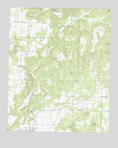
Blackgum, OK USGS Topographic Map
Click on map above to begin viewing in our Map Viewer.

This topographic map contains these locations and features:
Feature Name Type Latitude Longitude GNIS ID View Map
Anderson MountainSummitN35.51926°W94.90134°1089630View Map
Barnisky CemeteryCemeteryN35.60675°W94.93217°1089866View Map
BlackgumCivilN35.61424°W94.97614°2631073View Map
BlackgumPopulated PlaceN35.60982°W94.98968°1090225View Map
Blackgum Census Designated PlaceCensusN35.61118°W94.98997°2584374View Map
Blackgum MountainSummitN35.61732°W94.94745°1090227View Map
Blackgum Mountain Volunteer Fire Department Station 2BuildingN35.62418°W94.92830°2657211View Map
Blackgum Mountain Volunteer Fire Department Station 3BuildingN35.55866°W94.98038°2657333View Map
Boggy HollowValleyN35.50064°W94.92772°1090352View Map
BoxCivilN35.57898°W94.98482°2631074View Map
BoxPopulated PlaceN35.58121°W94.97634°1100229View Map
Box CemeteryCemeteryN35.58472°W94.97833°2710974View Map
Box Census Designated PlaceCensusN35.57834°W94.97192°2584375View Map
Cedar Grove CemeteryCemeteryN35.55175°W94.91467°1091113View Map
Cherokee-McCoy CemeteryCemeteryN35.61703°W94.90828°1091252View Map
Chuculate MountainSummitN35.57870°W94.93717°1091355View Map
Cowhead MountainSummitN35.58093°W94.87856°1091784View Map
Evening ShadeCivilN35.61950°W94.91030°2631106View Map
Evening ShadePopulated PlaceN35.62454°W94.92856°1853466View Map
Evening Shade Census Designated PlaceCensusN35.61950°W94.91030°2408096View Map
Lizzard MountainSummitN35.50843°W94.89467°1094872View Map
Pinhook CornerCivilN35.53138°W94.89102°2631155View Map
Pinhook CornerPopulated PlaceN35.53620°W94.88495°1096681View Map
Pinhook Corner Census Designated PlaceCensusN35.53138°W94.89102°2409074View Map
Pinhook CreekStreamN35.52621°W94.92440°1096682View Map
Round MountainSummitN35.58982°W94.87912°1097500View Map
Sallisaw Creek Site 3 DamDamN35.50343°W94.88189°1757045View Map
Sallisaw Creek Site 3 ReservoirReservoirN35.50343°W94.88189°1757046View Map
SycamoreCivilN35.53733°W94.93835°2631181View Map
Sycamore Census Designated PlaceCensusN35.53733°W94.93835°2410043View Map
Town of VianCivilN35.50183°W94.96990°2413431View Map
Township of BlackgumCivilN35.59176°W94.96412°1824603View Map
Vian Creek ChurchChurchN35.61370°W94.92217°1099252View Map
Vian DivisionCivilN35.52759°W94.97267°1937895View Map
Vian Garden of MemoriesCemeteryN35.51231°W94.97106°1099253View Map
Vian LakeReservoirN35.52010°W94.97042°1099254View Map
Wells HollowValleyN35.55064°W94.91244°1099481View Map

Note: Coordinates in the location and feature list above are referenced to NAD83 datum.


Copyright (C) 2008-2026 Ryan Niemi / Sunset Dynamics ... All Rights Reserved
