TopoQuest Logo
Do you find TopoQuest useful?
Help keep TopoQuest running and adding new maps/features by donating!
Home View Maps Find Maps Find Places Resources & Links


Dunbar, Oklahoma Topographic Map

USGS Map Title: Dunbar, OK
USGS Map MRC: 34095D5
DRG (GeoTIFF) Download: o34095d5.tif


Neighboring USGS Topographic Map Quads:


  Daisy, OK  
34095E6
 

  Adel, OK  
34095E5
 

  Stanley, OK  
34095E4
 

  Jumbo, OK  
34095D6
 

  Dunbar, OK  
34095D5
 

  Snow, OK  
34095D4
 

  Moyers, OK  
34095C6
 

  Kosoma, OK  
34095C5
 

  Finley, OK  
34095C4


Map MRC Location:

N35°
W96°
N35°
W95°
H8 H7 H6 H5 H4 H3 H2 H1
G8 G7 G6 G5 G4 G3 G2 G1
F8 F7 F6 F5 F4 F3 F2 F1
E8 E7 E6 E5 E4 E3 E2 E1
D8 D7 D6 D5 D4 D3 D2 D1
C8 C7 C6 C5 C4 C3 C2 C1
B8 B7 B6 B5 B4 B3 B2 B1
A8 A7 A6 A5 A4 A3 A2 A1
N34°
W96°
N34°
W95°

Dunbar, OK USGS 1:24K Topographic Map Preview:
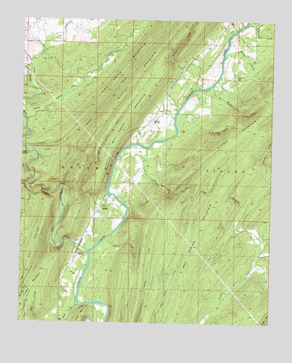
Dunbar, OK USGS Topographic Map
Click on map above to begin viewing in our Map Viewer.

This topographic map contains these locations and features:
Feature Name Type Latitude Longitude GNIS ID View Map
Beulah CreekStreamN34.49927°W95.51331°1090070View Map
Big MountainSummitN34.41538°W95.61442°1090122View Map
Blowout HollowValleyN34.46121°W95.54052°1090261View Map
Blowup CreekStreamN34.48454°W95.52525°1090262View Map
Box Spring MountainSummitN34.42371°W95.52969°1090435View Map
Bull CreekStreamN34.42760°W95.58247°1090664View Map
Bull Creek MountainSummitN34.47343°W95.56025°1090681View Map
DunbarPopulated PlaceN34.45871°W95.56053°1100370View Map
EubanksPopulated PlaceN34.42204°W95.58497°1100399View Map
Fobb CreekStreamN34.48843°W95.61553°1092916View Map
Hackett CreekStreamN34.47204°W95.53720°1093472View Map
Johns CreekStreamN34.47760°W95.62136°1094241View Map
Johns ValleyBasinN34.46510°W95.61359°1094243View Map
Little MountainSummitN34.39871°W95.60858°1094791View Map
Logan HollowValleyN34.44454°W95.62219°1094886View Map
Long Bell CreekStreamN34.44760°W95.56275°1094940View Map
Lost MountainSummitN34.37732°W95.59442°1095011View Map
Maddox CreekStreamN34.47288°W95.53108°1095081View Map
Marble CreekStreamN34.45871°W95.62275°1095136View Map
Monkeywrench CreekStreamN34.43704°W95.61997°1095478View Map
Mud CreekStreamN34.37510°W95.60442°1095669View Map
Pine CreekStreamN34.40427°W95.59136°1096653View Map
Reynolds CemeteryCemeteryN34.47704°W95.51913°1097179View Map
Stovepipe CreekStreamN34.40343°W95.50636°1098574View Map
Taylor CreekStreamN34.41038°W95.58108°1098769View Map
WadenaPopulated PlaceN34.40260°W95.59692°1100914View Map
Wildcat CreekStreamN34.43121°W95.60414°1099773View Map
Wildcat TrailTrailN34.44760°W95.60803°1099783View Map

Note: Coordinates in the location and feature list above are referenced to NAD83 datum.


Copyright (C) 2008-2026 Ryan Niemi / Sunset Dynamics ... All Rights Reserved
