TopoQuest Logo
Do you find TopoQuest useful?
Help keep TopoQuest running and adding new maps/features by donating!
Home View Maps Find Maps Find Places Resources & Links


Chewalla, Tennessee Topographic Map

USGS Map Title: Chewalla, TN
USGS Map MRC: 35088A6
DRG (GeoTIFF) Download: o35088a6.tif


Neighboring USGS Topographic Map Quads:


  Hornsby, TN  
35088B7
 

  Rose Creek, TN  
35088B6
 

  Purdy, TN  
35088B5
 

  Pocahontas, TN  
35088A7
 

  Chewalla, TN  
35088A6
 

  Guys, TN  
35088A5
 

  Chalybeate, MS  
34088H7
 

  Kossuth North, MS  
34088H6
 

  Corinth, MS  
34088H5


Map MRC Location:

N36°
W89°
N36°
W88°
H8 H7 H6 H5 H4 H3 H2 H1
G8 G7 G6 G5 G4 G3 G2 G1
F8 F7 F6 F5 F4 F3 F2 F1
E8 E7 E6 E5 E4 E3 E2 E1
D8 D7 D6 D5 D4 D3 D2 D1
C8 C7 C6 C5 C4 C3 C2 C1
B8 B7 B6 B5 B4 B3 B2 B1
A8 A7 A6 A5 A4 A3 A2 A1
N35°
W89°
N35°
W88°

Chewalla, TN USGS 1:24K Topographic Map Preview:
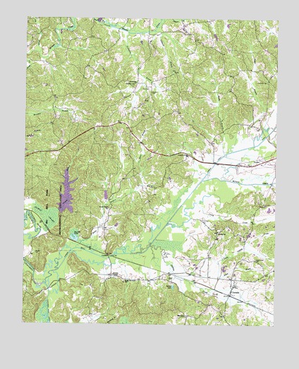
Chewalla, TN USGS Topographic Map
Click on map above to begin viewing in our Map Viewer.

This topographic map contains these locations and features:
Feature Name Type Latitude Longitude GNIS ID View Map
Allen BranchStreamN35.01842°W88.65311°1275573View Map
Antioch ChurchChurchN35.06953°W88.66977°1275795View Map
Big Hill PondLakeN35.03453°W88.72494°1277313View Map
Big Hill Pond LakeReservoirN35.05248°W88.72899°1301507View Map
Big Hill Pond Lake DamDamN35.04675°W88.73339°1301506View Map
Big Hill Pond State ParkAreaN35.04592°W88.73478°1308637View Map
Boles BranchStreamN35.03120°W88.72394°1277901View Map
Butlers ChapelChurchN35.02037°W88.70561°1305571View Map
Caney CreekStreamN35.04175°W88.67838°1279562View Map
Carr CemeteryCemeteryN35.09647°W88.69171°1279716View Map
ChewallaPopulated PlaceN35.01342°W88.64644°1280430View Map
Chewalla Baptist ChurchChurchN35.01564°W88.64533°1320087View Map
Chewalla Post OfficePost OfficeN35.01233°W88.64689°1649718View Map
Chewalla School (historical)SchoolN35.01620°W88.64311°1320088View Map
Coleman CemeteryCemeteryN35.09508°W88.68727°1280938View Map
Commissioner District 5CivilN35.05559°W88.65378°2464470View Map
CypressPopulated PlaceN35.02814°W88.70811°1314925View Map
Cypress CreekStreamN35.01620°W88.74005°1281922View Map
Cypress Creek DitchCanalN35.06453°W88.65644°1281940View Map
Dismal BranchStreamN35.04648°W88.73311°1282490View Map
Dismal SwampSwampN35.04398°W88.73922°1282495View Map
Dry BranchStreamN35.11092°W88.74394°1282875View Map
Friendship Baptist ChurchChurchN35.10009°W88.63005°1320091View Map
Friendship CemeteryCemeteryN35.09980°W88.62977°1284923View Map
Hurley SchoolSchoolN35.03731°W88.65338°1288773View Map
Indian CreekStreamN35.03231°W88.68700°1288955View Map
Indian Creek CemeteryCemeteryN35.02647°W88.63421°1288969View Map
Jimmies BranchStreamN35.12036°W88.68616°1289439View Map
Kings Mountain SchoolSchoolN35.01814°W88.69950°1290246View Map
Little Indian CreekStreamN35.01509°W88.66200°1328728View Map
McNairy County Fire Department Station 31 Chewalla Fire DepartmentBuildingN35.01846°W88.64909°2654000View Map
McNairy County Fire Department Station 33 Big Hill Pond Fire DepartmentBuildingN35.07473°W88.72759°2654193View Map
Muddy CreekStreamN35.05898°W88.66200°1295040View Map
Neatherly BranchStreamN35.11925°W88.69922°1295288View Map
Neatherly CemeteryCemeteryN35.09786°W88.69644°1295289View Map
Otterville ChurchChurchN35.09897°W88.69533°1296523View Map
Ramer BranchStreamN35.07342°W88.63588°1298873View Map
Reed SchoolSchoolN35.00342°W88.66950°1299152View Map
Reedy BranchStreamN35.06953°W88.65088°1299163View Map
Tan Yard BendBendN35.04231°W88.74755°1272072View Map
Turner CemeteryCemeteryN35.01869°W88.67782°1273063View Map
Turner LakeReservoirN35.01536°W88.67560°1273086View Map
Tuscumbia River CanalCanalN35.00581°W88.73764°1273109View Map
Union Chapel SchoolSchoolN35.04731°W88.70811°1273198View Map
White Oak CemeteryCemeteryN35.05647°W88.68588°1274390View Map
Wooten CemeteryCemeteryN35.02897°W88.74449°1275117View Map

Note: Coordinates in the location and feature list above are referenced to NAD83 datum.


Copyright (C) 2008-2026 Ryan Niemi / Sunset Dynamics ... All Rights Reserved
