TopoQuest Logo
Do you find TopoQuest useful?
Help keep TopoQuest running and adding new maps/features by donating!
Home View Maps Find Maps Find Places Resources & Links


Tanner, West Virginia Topographic Map

USGS Map Title: Tanner, WV
USGS Map MRC: 38080H8
DRG (GeoTIFF) Download: o38080h8.tif


Neighboring USGS Topographic Map Quads:


  Smithville, WV  
39081A1
 

  Burnt House, WV  
39080A8
 

  Auburn, WV  
39080A7
 

  Grantsville, WV  
38081H1
 

  Tanner, WV  
38080H8
 

  Glenville, WV  
38080H7
 

  Millstone, WV  
38081G1
 

  Normantown, WV  
38080G8
 

  Cedarville, WV  
38080G7


Map MRC Location:

N39°
W81°
N39°
W80°
H8 H7 H6 H5 H4 H3 H2 H1
G8 G7 G6 G5 G4 G3 G2 G1
F8 F7 F6 F5 F4 F3 F2 F1
E8 E7 E6 E5 E4 E3 E2 E1
D8 D7 D6 D5 D4 D3 D2 D1
C8 C7 C6 C5 C4 C3 C2 C1
B8 B7 B6 B5 B4 B3 B2 B1
A8 A7 A6 A5 A4 A3 A2 A1
N38°
W81°
N38°
W80°

Tanner, WV USGS 1:24K Topographic Map Preview:
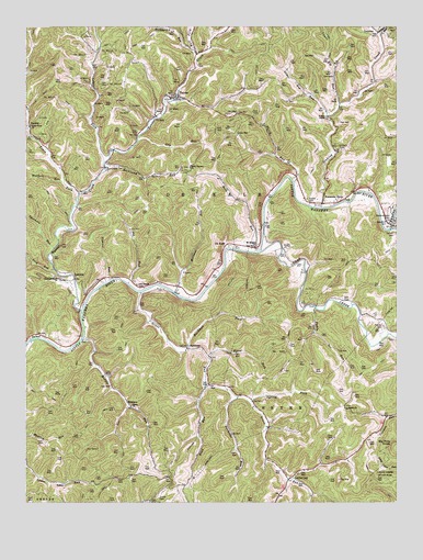
Tanner, WV USGS Topographic Map
Click on map above to begin viewing in our Map Viewer.

This topographic map contains these locations and features:
Feature Name Type Latitude Longitude GNIS ID View Map
Baptist Church CemeteryCemeteryN38.98143°W80.94801°2586253View Map
Barbecue RunStreamN38.90259°W80.92844°1535209View Map
Barton CemeteryCemeteryN38.94508°W80.87593°1535293View Map
Bell CemeteryCemeteryN38.92814°W80.89316°1535601View Map
Bell School (historical)SchoolN38.97648°W80.89816°1689640View Map
Big Pine KnobSummitN38.88981°W80.87733°1535894View Map
Bird School (historical)SchoolN38.87981°W80.94788°1689643View Map
Bull ForkStreamN38.99259°W80.94205°1536697View Map
Cedar CreekStreamN38.94092°W80.92094°1537127View Map
Chestnut Grove ChurchChurchN38.93398°W80.98844°1537278View Map
Crooked Run School (historical)SchoolN38.89842°W80.88705°1689656View Map
De KalbPopulated PlaceN38.94259°W80.93205°1554272View Map
De Kalb School (historical)SchoolN38.93009°W80.94261°1689660View Map
Dry RunStreamN38.97009°W80.96177°1538373View Map
Eliam ChurchChurchN38.90064°W80.96455°1538594View Map
Fishpot RunStreamN38.93370°W80.97177°1539007View Map
Grass RunStreamN38.93037°W80.96122°1539609View Map
HardmanPopulated PlaceN38.91564°W80.94538°1549727View Map
Hardman ForkStreamN38.91453°W80.94538°1539947View Map
Holbert CemeteryCemeteryN38.96869°W80.89427°1540376View Map
Holt RunStreamN38.94064°W80.92233°1540410View Map
Huffie SpringSpringN38.98287°W80.89538°1677974View Map
IndexLocaleN38.87981°W80.98678°1540664View Map
Job RunStreamN38.93259°W80.96566°1540914View Map
Job Run School (historical)SchoolN38.95037°W80.96372°1689685View Map
Jobs TempleChurchN38.93203°W80.96205°1540916View Map
Kanawha DrivePopulated PlaceN38.95370°W80.89955°1541064View Map
Keyster CemeteryCemeteryN38.92147°W80.87955°1541182View Map
LatoniaPopulated PlaceN38.93370°W80.98316°1549778View Map
Laurel ForkStreamN38.96425°W80.97344°1541464View Map
Laurel Fork School (historical)SchoolN38.97703°W80.97705°1689688View Map
Leading CreekStreamN38.94676°W80.87705°1541578View Map
Letter GapLocaleN38.88176°W80.91011°1541800View Map
Letter Gap Post OfficePost OfficeN38.88565°W80.90066°1689693View Map
Lick RunStreamN38.93592°W80.99011°1541940View Map
Lower Big RunStreamN38.97675°W80.89816°1542525View Map
LucernePopulated PlaceN38.99870°W80.88011°1549802View Map
Meadow Lane CemeteryCemeteryN38.94925°W80.87732°1543071View Map
Middle RunStreamN38.91731°W80.98094°1543216View Map
Millseat RunStreamN38.93009°W80.94872°1543416View Map
Mount Pisgah ChurchChurchN38.94259°W80.92177°1543737View Map
Paddy RunStreamN38.92592°W80.90233°1544517View Map
Panther RunStreamN38.99814°W80.88094°1544565View Map
RevorePopulated PlaceN38.97481°W80.99928°1555466View Map
Riddle CemeteryCemeteryN38.95480°W80.90482°1545569View Map
Road RunStreamN38.90509°W80.93844°1545828View Map
Rockcamp RunStreamN38.96342°W80.97372°1545947View Map
Shiloh ChurchChurchN38.89981°W80.89177°1546686View Map
Sinking CreekStreamN38.95287°W80.90066°1546832View Map
Spring ForkStreamN38.90092°W80.92400°1547190View Map
Sycamore RunStreamN38.94175°W80.99039°1547846View Map
TannerPopulated PlaceN38.98148°W80.94955°1547891View Map
Tanner CreekStreamN38.92509°W80.98094°1547893View Map
Tanner Post OfficePost OfficeN38.98203°W80.94816°1689746View Map
Third RunStreamN38.95926°W80.90983°1548015View Map
Third Run School (historical)SchoolN38.95648°W80.90622°1689747View Map
Three Poplars ChurchChurchN38.96287°W80.94455°1548069View Map
Trace ForkStreamN38.95592°W80.98233°1548231View Map
Trace Fork ChurchChurchN38.97398°W80.99816°1548238View Map
Turkeylick RunStreamN38.99398°W80.94316°1553292View Map
Turner CemeteryCemeteryN38.87647°W80.95538°1548380View Map
Upper Big RunStreamN38.97926°W80.89344°1548506View Map
Walnut Grove School (historical)SchoolN38.90370°W80.92872°1689756View Map
Wesley ChapelChurchN38.97620°W80.89844°1548913View Map
WithersPopulated PlaceN38.89981°W80.96455°1549996View Map
Wolfpen RunStreamN38.95925°W80.98705°1549342View Map
Woodford CemeteryCemeteryN38.94842°W80.87760°1549371View Map
Wyant ForkStreamN38.91287°W80.93761°1549438View Map

Note: Coordinates in the location and feature list above are referenced to NAD83 datum.


Copyright (C) 2008-2026 Ryan Niemi / Sunset Dynamics ... All Rights Reserved
