TopoQuest Logo
Do you find TopoQuest useful?
Help keep TopoQuest running and adding new maps/features by donating!
Bitcoin:  19c7KJd3qBynnjoSw5npx9KScwjBe4ifkT
Litecoin:  LXs6TkuXGGXo1vDsWCkWVdjQX94eUKd6ui
Home View Maps Find Maps Find Places Resources & Links


Danciger, Texas Topographic Map

USGS Map Title: Danciger, TX
USGS Map MRC: 29095B7
DRG (GeoTIFF) Download: o29095b7.tif


Neighboring USGS Topographic Map Quads:


  Boling, TX  
29095C8
 

  Guy, TX  
29095C7
 

  Damon, TX  
29095C6
 

  Pledger, TX  
29095B8
 

  Danciger, TX  
29095B7
 

  West Columbia, TX  
29095B6
 

  Van Vleck, TX  
29095A8
 

  Ashwood, TX  
29095A7
 

  Sweeny, TX  
29095A6


Map MRC Location:

N30°
W96°
N30°
W95°
H8 H7 H6 H5 H4 H3 H2 H1
G8 G7 G6 G5 G4 G3 G2 G1
F8 F7 F6 F5 F4 F3 F2 F1
E8 E7 E6 E5 E4 E3 E2 E1
D8 D7 D6 D5 D4 D3 D2 D1
C8 C7 C6 C5 C4 C3 C2 C1
B8 B7 B6 B5 B4 B3 B2 B1
A8 A7 A6 A5 A4 A3 A2 A1
N29°
W96°
N29°
W95°

Danciger, TX USGS 1:24K Topographic Map Preview:
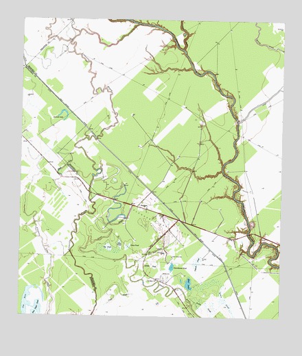
Danciger, TX USGS Topographic Map
Click on map above to begin viewing in our Map Viewer.

This topographic map contains these locations and features:
Feature Name Type Latitude Longitude GNIS ID View Map
Alligator LakeLakeN29.1542°W95.8635°1351017View Map
Big PondSwampN29.1541°W95.8333°1352114View Map
Bird PondLakeN29.1392°W95.7939°1352228View Map
Black LakeLakeN29.1883°W95.8541°1352330View Map
Blue PondSwampN29.1547°W95.8272°1352483View Map
Brown CemeteryCemeteryN29.1433°W95.8058°1352963View Map
Camp PondSwampN29.1541°W95.8236°1353660View Map
Carson PondSwampN29.1466°W95.8119°1353886View Map
Cat BayouGutN29.1533°W95.8097°1353949View Map
Cedar CreekStreamN29.2377°W95.7980°1354065View Map
Cedar Grove CemeteryCemeteryN29.1502°W95.8019°1354092View Map
Churchhouse PondLakeN29.1453°W95.8025°1354492View Map
DancigerPopulated PlaceN29.1716°W95.8188°1355627View Map
Danciger Post OfficePost OfficeN29.1687°W95.8090°2732343View Map
Jug HoleLakeN29.1305°W95.8719°1360457View Map
Lones PondSwampN29.1316°W95.7758°1361683View Map
Pasture PondSwampN29.1477°W95.7894°1364863View Map
Pledger Gas FieldOilfieldN29.1647°W95.8077°1365465View Map
Rusha PondSwampN29.1300°W95.7855°1367023View Map
Saint Mary ChurchChurchN29.1405°W95.8094°1367253View Map
Sawmill LakeLakeN29.2074°W95.8554°1367801View Map
Shoe Sugar PondLakeN29.1275°W95.8667°1368217View Map
Vinie SloughGutN29.1372°W95.8263°1370658View Map

Note: Coordinates in the location and feature list above are referenced to NAD83 datum.


Copyright (C) 2008-2024 Ryan Niemi / Sunset Dynamics ... All Rights Reserved