TopoQuest Logo
Do you find TopoQuest useful?
Help keep TopoQuest running and adding new maps/features by donating!
Bitcoin:  19c7KJd3qBynnjoSw5npx9KScwjBe4ifkT
Litecoin:  LXs6TkuXGGXo1vDsWCkWVdjQX94eUKd6ui
Home View Maps Find Maps Find Places Resources & Links


West Columbia, Texas Topographic Map

USGS Map Title: West Columbia, TX
USGS Map MRC: 29095B6
DRG (GeoTIFF) Download: o29095b6.tif


Neighboring USGS Topographic Map Quads:


  Guy, TX  
29095C7
 

  Damon, TX  
29095C6
 

  Otey, TX  
29095C5
 

  Danciger, TX  
29095B7
 

  West Columbia, TX  
29095B6
 

  East Columbia, TX  
29095B5
 

  Ashwood, TX  
29095A7
 

  Sweeny, TX  
29095A6
 

  Brazoria, TX  
29095A5


Map MRC Location:

N30°
W96°
N30°
W95°
H8 H7 H6 H5 H4 H3 H2 H1
G8 G7 G6 G5 G4 G3 G2 G1
F8 F7 F6 F5 F4 F3 F2 F1
E8 E7 E6 E5 E4 E3 E2 E1
D8 D7 D6 D5 D4 D3 D2 D1
C8 C7 C6 C5 C4 C3 C2 C1
B8 B7 B6 B5 B4 B3 B2 B1
A8 A7 A6 A5 A4 A3 A2 A1
N29°
W96°
N29°
W95°

West Columbia, TX USGS 1:24K Topographic Map Preview:
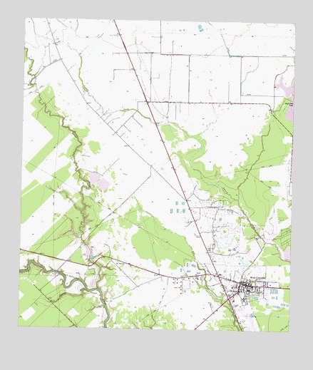
West Columbia, TX USGS Topographic Map
Click on map above to begin viewing in our Map Viewer.

This topographic map contains these locations and features:
Feature Name Type Latitude Longitude GNIS ID View Map
Blackwell ReservoirReservoirN29.2038°W95.7385°1857698View Map
Blackwell Reservoir LeveeDamN29.2019°W95.7369°1857697View Map
Brazoria County Constable's Office Precinct 4BuildingN29.1450°W95.6326°2751286View Map
Brazoria County Juvenile Justice Alternative Education ProgramSchoolN29.1376°W95.6507°2434553View Map
Cannon GullyValleyN29.1410°W95.7193°1353757View Map
Central Emergency Medical ServicesBuildingN29.1485°W95.6413°2720896View Map
Charlie Brown Intermediate School (closed)SchoolN29.1428°W95.6512°2003485View Map
City of West ColumbiaCivilN29.1419°W95.6488°2412218View Map
Columbia High SchoolSchoolN29.1379°W95.6503°2003487View Map
Columbia Historical Museum AssociationBuildingN29.1433°W95.6397°2014248View Map
Light House Christian AcademySchoolN29.1458°W95.6522°2434559View Map
Mound CreekStreamN29.1408°W95.7127°1363219View Map
Saint Paul ChurchChurchN29.1525°W95.7038°1367290View Map
Varner Hogg Plantation State Historical ParkParkN29.1630°W95.6397°2030010View Map
West ColumbiaPopulated PlaceN29.1439°W95.6452°1371096View Map
West Columbia City HallBuildingN29.1446°W95.6419°2753997View Map
West Columbia Elementary SchoolSchoolN29.1356°W95.6442°2003410View Map
West Columbia Fire Marshal's OfficeBuildingN29.1429°W95.6452°2334795View Map
West Columbia Independent School District Football StadiumParkN29.1377°W95.6486°2027583View Map
West Columbia Junior High School (closed)SchoolN29.1419°W95.6442°2003411View Map
West Columbia Oil FieldOilfieldN29.1691°W95.6583°1371097View Map
West Columbia Police DepartmentBuildingN29.1430°W95.6452°2375797View Map
West Columbia Post OfficePost OfficeN29.1462°W95.6519°2731353View Map
West Columbia Volunteer Fire DepartmentBuildingN29.1430°W95.6447°2334345View Map
Williams Lake Number 1ReservoirN29.1936°W95.7019°1857694View Map
Williams Lake Number 1 LeveeDamN29.1936°W95.7019°1857693View Map
Williams Lake Number 2ReservoirN29.1936°W95.7069°1857696View Map
Williams Lake Number 2 LeveeDamN29.1936°W95.7069°1857695View Map

Note: Coordinates in the location and feature list above are referenced to NAD83 datum.


Copyright (C) 2008-2024 Ryan Niemi / Sunset Dynamics ... All Rights Reserved