TopoQuest Logo
Do you find TopoQuest useful?
Help keep TopoQuest running and adding new maps/features by donating!
Bitcoin:  19c7KJd3qBynnjoSw5npx9KScwjBe4ifkT
Litecoin:  LXs6TkuXGGXo1vDsWCkWVdjQX94eUKd6ui
Home View Maps Find Maps Find Places Resources & Links


Sweeny, Texas Topographic Map

USGS Map Title: Sweeny, TX
USGS Map MRC: 29095A6
DRG (GeoTIFF) Download: o29095a6.tif


Neighboring USGS Topographic Map Quads:


  Danciger, TX  
29095B7
 

  West Columbia, TX  
29095B6
 

  East Columbia, TX  
29095B5
 

  Ashwood, TX  
29095A7
 

  Sweeny, TX  
29095A6
 

  Brazoria, TX  
29095A5
 

  Bay City NE, TX  
28095H7
 

  Cedar Lane, TX  
28095H6
 

  Cedar Lane NE, TX  
28095H5


Map MRC Location:

N30°
W96°
N30°
W95°
H8 H7 H6 H5 H4 H3 H2 H1
G8 G7 G6 G5 G4 G3 G2 G1
F8 F7 F6 F5 F4 F3 F2 F1
E8 E7 E6 E5 E4 E3 E2 E1
D8 D7 D6 D5 D4 D3 D2 D1
C8 C7 C6 C5 C4 C3 C2 C1
B8 B7 B6 B5 B4 B3 B2 B1
A8 A7 A6 A5 A4 A3 A2 A1
N29°
W96°
N29°
W95°

Sweeny, TX USGS 1:24K Topographic Map Preview:
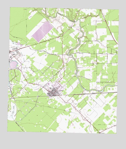
Sweeny, TX USGS Topographic Map
Click on map above to begin viewing in our Map Viewer.

This topographic map contains these locations and features:
Feature Name Type Latitude Longitude GNIS ID View Map
Bell CreekStreamN29.1147°W95.6694°1372487View Map
Brazoria County Juvenile Justice Alternative Education ProgramSchoolN29.0482°W95.7063°2434550View Map
Brazoria-West Columbia DivisionCivilN29.0724°W95.6392°1938557View Map
City of SweenyCivilN29.0461°W95.6985°2412021View Map
El BernardoPopulated PlaceN29.0402°W95.6527°1379706View Map
Flag PondLakeN29.0911°W95.7487°1373730View Map
Four CornersPopulated PlaceN29.0019°W95.6455°2034923View Map
Four CornersLocaleN29.0008°W95.6441°1357627View Map
Markle LakeReservoirN29.0647°W95.7453°1863424View Map
Markle Lake LeveeDamN29.0636°W95.7469°1863423View Map
Old OceanPopulated PlaceN29.0800°W95.7497°1364454View Map
Old Ocean Oil FieldOilfieldN29.0403°W95.7322°1364455View Map
Old Ocean SwampSwampN29.0172°W95.7461°1364456View Map
Old Ocean Volunteer Fire DepartmentBuildingN29.0823°W95.7497°2655310View Map
San Bernard Reservoir Number 1ReservoirN29.1119°W95.7069°1857690View Map
San Bernard Reservoir Number 1 LeveeDamN29.1119°W95.7069°1857689View Map
San Bernard Reservoir Number 2ReservoirN29.0973°W95.7170°1857692View Map
San Bernard Reservoir Number 2 LeveeDamN29.0986°W95.7102°1857691View Map
San Bernard Reservoir Number 3ReservoirN29.1052°W95.7169°1863426View Map
San Bernard Reservoir Number 3 LeveeDamN29.1052°W95.7169°1863425View Map
Sweeney City HallBuildingN29.0453°W95.7113°2753452View Map
SweenyPopulated PlaceN29.0389°W95.6986°1369461View Map
Sweeny Christian SchoolSchoolN29.0421°W95.7081°2434250View Map
Sweeny Community HospitalHospitalN29.0477°W95.6917°2015636View Map
Sweeny Elementary SchoolSchoolN29.0408°W95.7077°2003475View Map
Sweeny Fire and RescueBuildingN29.0388°W95.6997°2334505View Map
Sweeny High SchoolSchoolN29.0491°W95.7052°2003476View Map
Sweeny Junior High SchoolSchoolN29.0456°W95.7026°2003477View Map
Sweeny Optional SchoolSchoolN29.0453°W95.7033°2003478View Map
Sweeny Police DepartmentBuildingN29.0392°W95.6981°2375975View Map
Sweeny Post OfficePost OfficeN29.0407°W95.6974°2731267View Map
Washington ChapelChurchN29.0439°W95.7333°1370879View Map
Wild Peach VillagePopulated PlaceN29.0836°W95.6338°1867574View Map
Wild Peach Village Census Designated PlaceCensusN29.0810°W95.6372°2409592View Map
Wild Peach Volunteer Fire DepartmentBuildingN29.0805°W95.6304°2334576View Map
Wilson Point ChurchChurchN29.0802°W95.6699°1371725View Map

Note: Coordinates in the location and feature list above are referenced to NAD83 datum.


Copyright (C) 2008-2024 Ryan Niemi / Sunset Dynamics ... All Rights Reserved