TopoQuest Logo
Do you find TopoQuest useful?
Help keep TopoQuest running and adding new maps/features by donating!
Bitcoin:  19c7KJd3qBynnjoSw5npx9KScwjBe4ifkT
Litecoin:  LXs6TkuXGGXo1vDsWCkWVdjQX94eUKd6ui
Home View Maps Find Maps Find Places Resources & Links


Duralde, Louisiana Topographic Map

USGS Map Title: Duralde, LA
USGS Map MRC: 30092E5
DRG (GeoTIFF) Download: o30092e5.tif


Neighboring USGS Topographic Map Quads:


  Guy, LA  
30092F6
 

  Bond, LA  
30092F5
 

  Mamou, LA  
30092F4
 

  Soileau, LA  
30092E6
 

  Duralde, LA  
30092E5
 

  Eunice North, LA  
30092E4
 

  Elton, LA  
30092D6
 

  Basile, LA  
30092D5
 

  Eunice South, LA  
30092D4


Map MRC Location:

N31°
W93°
N31°
W92°
H8 H7 H6 H5 H4 H3 H2 H1
G8 G7 G6 G5 G4 G3 G2 G1
F8 F7 F6 F5 F4 F3 F2 F1
E8 E7 E6 E5 E4 E3 E2 E1
D8 D7 D6 D5 D4 D3 D2 D1
C8 C7 C6 C5 C4 C3 C2 C1
B8 B7 B6 B5 B4 B3 B2 B1
A8 A7 A6 A5 A4 A3 A2 A1
N30°
W93°
N30°
W92°

Duralde, LA USGS 1:24K Topographic Map Preview:
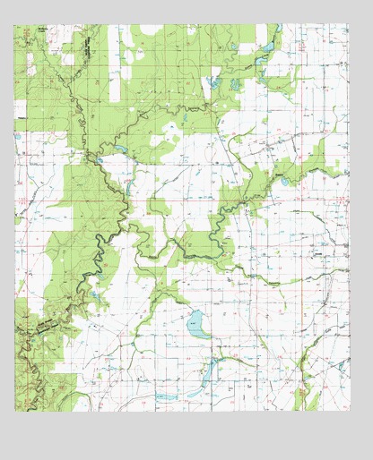
Duralde, LA USGS Topographic Map
Click on map above to begin viewing in our Map Viewer.

This topographic map contains these locations and features:
Feature Name Type Latitude Longitude GNIS ID View Map
Acadia - Evangeline Fire Protection District Station 2BuildingN30.5498°W92.5374°2691829View Map
Annunciation ChurchChurchN30.5496°W92.5145°2600534View Map
Bayou BlueStreamN30.5246°W92.6199°553417View Map
Bayou DuraldeStreamN30.5591°W92.5849°532585View Map
Caney CreekStreamN30.6049°W92.6049°533741View Map
Castor CreekStreamN30.5833°W92.5979°533811View Map
Cezar CemeteryCemeteryN30.5866°W92.5404°533862View Map
Coulee ValentineStreamN30.5496°W92.5512°534181View Map
Duplechien GullyStreamN30.6205°W92.6238°534660View Map
DuraldePopulated PlaceN30.5499°W92.5137°542143View Map
East Basile Oil and Gas FieldOilfieldN30.5349°W92.5251°545684View Map
Fruge Lake (historical)LakeN30.5433°W92.6121°545447View Map
Grand Louis BayouStreamN30.6094°W92.5437°554584View Map
HamptonPopulated PlaceN30.5946°W92.6204°554654View Map
Mulberry CreekStreamN30.6205°W92.6171°537488View Map
North Basile Oil FieldOilfieldN30.5066°W92.5643°545709View Map
Parish Governing Authority District 2CivilN30.5330°W92.5495°1929892View Map
Veillon CemeteryCemeteryN30.5896°W92.5235°540145View Map
Ward TwoCivilN30.5180°W92.5449°545022View Map
West Duralde Oil FieldOilfieldN30.5977°W92.6246°545477View Map
West Fenris Gas FieldOilfieldN30.5830°W92.5362°545735View Map

Note: Coordinates in the location and feature list above are referenced to NAD83 datum.


Copyright (C) 2008-2024 Ryan Niemi / Sunset Dynamics ... All Rights Reserved