TopoQuest Logo
Do you find TopoQuest useful?
Help keep TopoQuest running and adding new maps/features by donating!
Bitcoin:  19c7KJd3qBynnjoSw5npx9KScwjBe4ifkT
Litecoin:  LXs6TkuXGGXo1vDsWCkWVdjQX94eUKd6ui
Home View Maps Find Maps Find Places Resources & Links


Easton, Illinois Topographic Map

USGS Map Title: Easton, IL
USGS Map MRC: 40089B7
DRG (GeoTIFF) Download: o40089b7.tif


Neighboring USGS Topographic Map Quads:


  Topeka, IL  
40089C8
 

  Forest City, IL  
40089C7
 

  Natrona, IL  
40089C6
 

  Biggs, IL  
40089B8
 

  Easton, IL  
40089B7
 

  Mason City, IL  
40089B6
 

  Oakford, IL  
40089A8
 

  Petersburg, IL  
40089A7
 

  Greenview, IL  
40089A6


Map MRC Location:

N41°
W90°
N41°
W89°
H8 H7 H6 H5 H4 H3 H2 H1
G8 G7 G6 G5 G4 G3 G2 G1
F8 F7 F6 F5 F4 F3 F2 F1
E8 E7 E6 E5 E4 E3 E2 E1
D8 D7 D6 D5 D4 D3 D2 D1
C8 C7 C6 C5 C4 C3 C2 C1
B8 B7 B6 B5 B4 B3 B2 B1
A8 A7 A6 A5 A4 A3 A2 A1
N40°
W90°
N40°
W89°

Easton, IL USGS 1:24K Topographic Map Preview:
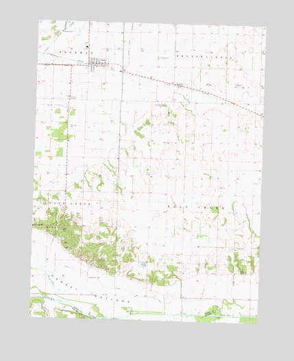
Easton, IL USGS Topographic Map
Click on map above to begin viewing in our Map Viewer.

This topographic map contains these locations and features:
Feature Name Type Latitude Longitude GNIS ID View Map
Agnew LakeLakeN40.1514°W89.8114°423856View Map
Big Grove CemeteryCemeteryN40.1464°W89.7615°404409View Map
Blue HoleLakeN40.1295°W89.8205°404590View Map
Crites CemeteryCemeteryN40.1839°W89.7543°1964891View Map
Danville School (historical)SchoolN40.1856°W89.8159°423860View Map
EastonPopulated PlaceN40.2325°W89.8426°407717View Map
Easton CemeteryCemeteryN40.2181°W89.8548°407718View Map
Easton Post OfficePost OfficeN40.2322°W89.8442°2788705View Map
Easton Rural Fire DepartmentBuildingN40.2314°W89.8422°2640199View Map
Grove CreekStreamN40.1256°W89.8243°409538View Map
Hall DitchCanalN40.2145°W89.8718°409658View Map
Haw Grove School (historical)SchoolN40.1817°W89.7732°423861View Map
Herget BottomsFlatN40.1442°W89.8651°410092View Map
Illini Central Middle SchoolSchoolN40.2395°W89.8482°1821482View Map
Knox School (historical)SchoolN40.1462°W89.7779°423863View Map
Latimore CreekStreamN40.1331°W89.8676°411843View Map
Leases Grove CemeteryCemeteryN40.2156°W89.8055°411896View Map
Leases Grove Church (historical)ChurchN40.2078°W89.7973°423864View Map
Leases Grove School (historical)SchoolN40.2081°W89.8068°423865View Map
Leveldale CemeteryCemeteryN40.2356°W89.8087°411959View Map
Leveldale School (historical)SchoolN40.2392°W89.7843°423866View Map
McCarty School (historical)SchoolN40.1570°W89.8115°423867View Map
Mount Olive Church (historical)ChurchN40.1639°W89.8115°423868View Map
New Hope CemeteryCemeteryN40.2056°W89.8568°414415View Map
Reavis Spring School (historical)SchoolN40.1534°W89.8548°423872View Map
Revis Hill Prairie Nature PreserveParkN40.1534°W89.8451°2009797View Map
Revis LakeLakeN40.1411°W89.8650°416564View Map
Revis SpringSpringN40.1628°W89.8615°416565View Map
Ross Tyrell DitchCanalN40.2442°W89.8248°416977View Map
Salt CreekStreamN40.1259°W89.8257°426594View Map
Salt Creek TownhallBuildingN40.1817°W89.7732°1720378View Map
Samuels DitchCanalN40.2314°W89.8643°417921View Map
Sleepy HollowValleyN40.1676°W89.7823°423875View Map
Smith LakeLakeN40.1483°W89.8133°418639View Map
TeheranPopulated PlaceN40.2245°W89.7990°423235View Map
Township of Salt CreekCivilN40.1731°W89.7746°429706View Map
Village of EastonCivilN40.2321°W89.8416°2398780View Map
Walker Grove School (historical)SchoolN40.2003°W89.8576°423876View Map

Note: Coordinates in the location and feature list above are referenced to NAD83 datum.


Copyright (C) 2008-2024 Ryan Niemi / Sunset Dynamics ... All Rights Reserved