TopoQuest Logo
Do you find TopoQuest useful?
Help keep TopoQuest running and adding new maps/features by donating!
Bitcoin:  19c7KJd3qBynnjoSw5npx9KScwjBe4ifkT
Litecoin:  LXs6TkuXGGXo1vDsWCkWVdjQX94eUKd6ui
Home View Maps Find Maps Find Places Resources & Links


El Paso, Wisconsin Topographic Map

USGS Map Title: El Paso, WI
USGS Map MRC: 44092G3
DRG (GeoTIFF) Download: o44092g3.tif


Neighboring USGS Topographic Map Quads:


  Baldwin West, WI  
44092H4
 

  Baldwin East, WI  
44092H3
 

  Wilson, WI  
44092H2
 

  Martell, WI  
44092G4
 

  El Paso, WI  
44092G3
 

  Spring Valley, WI  
44092G2
 

  Ellsworth, WI  
44092F4
 

  Waverly, WI  
44092F3
 

  Plum City, WI  
44092F2


Map MRC Location:

N45°
W93°
N45°
W92°
H8 H7 H6 H5 H4 H3 H2 H1
G8 G7 G6 G5 G4 G3 G2 G1
F8 F7 F6 F5 F4 F3 F2 F1
E8 E7 E6 E5 E4 E3 E2 E1
D8 D7 D6 D5 D4 D3 D2 D1
C8 C7 C6 C5 C4 C3 C2 C1
B8 B7 B6 B5 B4 B3 B2 B1
A8 A7 A6 A5 A4 A3 A2 A1
N44°
W93°
N44°
W92°

El Paso, WI USGS 1:24K Topographic Map Preview:
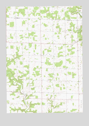
El Paso, WI USGS Topographic Map
Click on map above to begin viewing in our Map Viewer.

This topographic map contains these locations and features:
Feature Name Type Latitude Longitude GNIS ID View Map
El PasoPopulated PlaceN44.7697°W92.3441°1564482View Map
Gilman Center School (historical)SchoolN44.8169°W92.3049°1578330View Map
Gilman Lutheran CemeteryCemeteryN44.8313°W92.2995°1964274View Map
Gilman Lutheran ChurchChurchN44.8311°W92.2988°1565534View Map
Gilman SchoolSchoolN44.8089°W92.3171°1565535View Map
Gilman TownhallBuildingN44.8172°W92.3141°1831585View Map
Locust Grove School (historical)SchoolN44.8469°W92.3482°1578341View Map
Lone Balsam School (historical)SchoolN44.8180°W92.3480°1578342View Map
Maple Leaf OrchardLocaleN44.8078°W92.3306°2611794View Map
Mines School (historical)SchoolN44.8452°W92.2902°1578349View Map
OlivetPopulated PlaceN44.7864°W92.2571°1570802View Map
Peniel Christian SchoolSchoolN44.8257°W92.3484°2715771View Map
Sacred Heart CemeteryCemeteryN44.8450°W92.2571°1572785View Map
Saint Josephs Catholic CemeteryCemeteryN44.7688°W92.3480°1964281View Map
Saint Josephs Catholic Church (historical)ChurchN44.7691°W92.3477°1964282View Map
South Hill School (historical)SchoolN44.8158°W92.2580°1578368View Map
Spring Valley High SchoolSchoolN44.8283°W92.2550°2715664View Map
Spring Valley Middle SchoolSchoolN44.8283°W92.2550°2715833View Map
Town of GilmanCivilN44.8164°W92.3174°1583275View Map
VikingPopulated PlaceN44.8616°W92.3591°1581751View Map
Wildwood School (historical)SchoolN44.8739°W92.2946°1581810View Map
Wood School (historical)SchoolN44.7547°W92.2871°1578374View Map

Note: Coordinates in the location and feature list above are referenced to NAD83 datum.


Copyright (C) 2008-2024 Ryan Niemi / Sunset Dynamics ... All Rights Reserved