TopoQuest Logo
Do you find TopoQuest useful?
Help keep TopoQuest running and adding new maps/features by donating!
Bitcoin:  19c7KJd3qBynnjoSw5npx9KScwjBe4ifkT
Litecoin:  LXs6TkuXGGXo1vDsWCkWVdjQX94eUKd6ui
Home View Maps Find Maps Find Places Resources & Links


Evansville, Illinois Topographic Map

USGS Map Title: Evansville, IL
USGS Map MRC: 38089A8
DRG (GeoTIFF) Download: o38089a8.tif


Neighboring USGS Topographic Map Quads:


  Ames, IL  
38090B1
 

  Red Bud, IL  
38089B8
 

  Baldwin, IL  
38089B7
 

  Prairie du Rocher, IL  
38090A1
 

  Evansville, IL  
38089A8
 

  Walsh, IL  
38089A7
 

  Sainte Genevieve, MO  
37090H1
 

  Kaskaskia, IL  
37089H8
 

  Chester, IL  
37089H7


Map MRC Location:

N39°
W90°
N39°
W89°
H8 H7 H6 H5 H4 H3 H2 H1
G8 G7 G6 G5 G4 G3 G2 G1
F8 F7 F6 F5 F4 F3 F2 F1
E8 E7 E6 E5 E4 E3 E2 E1
D8 D7 D6 D5 D4 D3 D2 D1
C8 C7 C6 C5 C4 C3 C2 C1
B8 B7 B6 B5 B4 B3 B2 B1
A8 A7 A6 A5 A4 A3 A2 A1
N38°
W90°
N38°
W89°

Evansville, IL USGS 1:24K Topographic Map Preview:
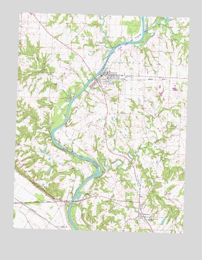
Evansville, IL USGS Topographic Map
Click on map above to begin viewing in our Map Viewer.

This topographic map contains these locations and features:
Feature Name Type Latitude Longitude GNIS ID View Map
Belle Vista School (historical)SchoolN38.0681°W89.9165°1764816View Map
Bollinger School (historical)SchoolN38.0134°W89.8793°1764820View Map
Butter CreekStreamN38.0498°W89.9043°405300View Map
Camp CreekStreamN38.0756°W89.9601°405447View Map
Campbell School (historical)SchoolN38.0909°W89.8979°1764823View Map
CollinsPopulated PlaceN38.0209°W89.9479°422569View Map
Crooked CreekStreamN38.0562°W89.9746°406807View Map
Dale Curten Farm AirportAirportN38.0481°W89.9942°427552View Map
Ellis GrovePopulated PlaceN38.0089°W89.9059°407898View Map
Ellis Grove Election PrecinctCivilN38.0035°W89.8978°1928492View Map
Ellis Grove Fire DepartmentBuildingN38.0156°W89.9088°2640412View Map
Ellis Grove Post OfficePost OfficeN38.0093°W89.9062°2788576View Map
EvansvillePopulated PlaceN38.0903°W89.9384°408104View Map
Evansville Attendance CenterSchoolN38.0923°W89.9326°1820679View Map
Evansville Election PrecinctCivilN38.0909°W89.9361°1928494View Map
Evansville Fire DepartmentBuildingN38.0899°W89.9371°2640402View Map
Evansville Police DepartmentBuildingN38.0907°W89.9362°2758897View Map
Evansville Post OfficePost OfficeN38.0899°W89.9386°2788237View Map
Hapke School (historical)SchoolN38.1126°W89.9837°1764841View Map
Harmony School (historical)SchoolN38.0087°W89.9351°1764842View Map
Horse CreekStreamN38.1056°W89.9321°410554View Map
Kelly CemeteryCemeteryN38.0962°W89.9065°411368View Map
Little Ninemile CreekStreamN38.0442°W89.9109°412384View Map
McCormick CemeteryCemeteryN38.0564°W89.8851°413225View Map
Ninemile CreekStreamN38.0337°W89.9365°414529View Map
Pautler School (historical)SchoolN38.0617°W89.9357°1764874View Map
Phegley School (historical)SchoolN38.0620°W89.9965°1764877View Map
Plum CreekStreamN38.1167°W89.9068°415950View Map
Redoak School (historical)SchoolN38.0598°W89.8796°1764883View Map
Riverveiw AirportAirportN38.0778°W89.9768°427268View Map
Rocky BranchStreamN38.0539°W89.8959°416868View Map
RootsPopulated PlaceN38.0178°W89.9723°423132View Map
Ruma Election PrecinctCivilN38.1207°W89.9979°1928637View Map
Saint Boniface CemeteryCemeteryN38.0898°W89.9223°417209View Map
Saint Johns ChurchChurchN38.1192°W89.9804°417394View Map
Saint Leo ChurchChurchN38.0248°W89.9804°417509View Map
Saint Peters CemeteryCemeteryN38.0884°W89.9254°417744View Map
Schaffner LakeReservoirN38.1241°W89.8915°1691641View Map
Schaffner Lake Number 1 DamDamN38.1234°W89.8918°1691640View Map
Stipe CemeteryCemeteryN38.0328°W89.8962°419147View Map
Village of Ellis GroveCivilN38.0094°W89.9100°2398809View Map
Village of EvansvilleCivilN38.0889°W89.9323°2398844View Map

Note: Coordinates in the location and feature list above are referenced to NAD83 datum.


Copyright (C) 2008-2024 Ryan Niemi / Sunset Dynamics ... All Rights Reserved