TopoQuest Logo
Do you find TopoQuest useful?
Help keep TopoQuest running and adding new maps/features by donating!
Bitcoin:  19c7KJd3qBynnjoSw5npx9KScwjBe4ifkT
Litecoin:  LXs6TkuXGGXo1vDsWCkWVdjQX94eUKd6ui
Home View Maps Find Maps Find Places Resources & Links


Kaskaskia, Illinois Topographic Map

USGS Map Title: Kaskaskia, IL
USGS Map MRC: 37089H8
DRG (GeoTIFF) Download: o37089h8.tif


Neighboring USGS Topographic Map Quads:


  Prairie du Rocher, IL  
38090A1
 

  Evansville, IL  
38089A8
 

  Walsh, IL  
38089A7
 

  Sainte Genevieve, MO  
37090H1
 

  Kaskaskia, IL  
37089H8
 

  Chester, IL  
37089H7
 

  Minnith, MO  
37090G1
 

  Lithium, MO  
37089G8
 

  Belgique, MO  
37089G7


Map MRC Location:

N38°
W90°
N38°
W89°
H8 H7 H6 H5 H4 H3 H2 H1
G8 G7 G6 G5 G4 G3 G2 G1
F8 F7 F6 F5 F4 F3 F2 F1
E8 E7 E6 E5 E4 E3 E2 E1
D8 D7 D6 D5 D4 D3 D2 D1
C8 C7 C6 C5 C4 C3 C2 C1
B8 B7 B6 B5 B4 B3 B2 B1
A8 A7 A6 A5 A4 A3 A2 A1
N37°
W90°
N37°
W89°

Kaskaskia, IL USGS 1:24K Topographic Map Preview:
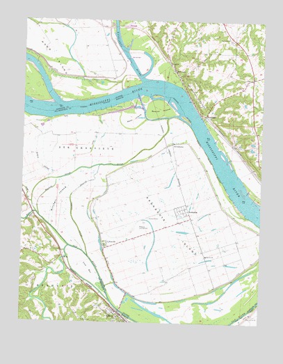
Kaskaskia, IL USGS Topographic Map
Click on map above to begin viewing in our Map Viewer.

This topographic map contains these locations and features:
Feature Name Type Latitude Longitude GNIS ID View Map
Beaver IslandIslandN37.9628°W89.9282°404061View Map
Cain Hill School (historical)SchoolN37.9784°W89.9157°1764822View Map
Cow BarBarN37.8973°W89.9664°716402View Map
Delassus Landing Field (historical)AirportN37.9142°W89.9393°1764831View Map
Dodge CreekStreamN37.9242°W89.9946°716938View Map
DozavillePopulated PlaceN37.9070°W89.9565°407374View Map
Farmers LandingLocaleN37.9453°W89.9043°1764835View Map
Fort GagePopulated PlaceN37.9606°W89.9046°422708View Map
Fort Kaskaskia (historical)MilitaryN37.9664°W89.9072°1820685View Map
Fort Kaskaskia State ParkParkN37.9689°W89.9096°408552View Map
French Colonial Historic DistrictParkN37.9598°W89.9057°1820686View Map
HicksPopulated PlaceN37.9226°W89.9954°739942View Map
Idlewild SloughGutN37.9364°W89.9612°426380View Map
Idlewild SloughStreamN37.9023°W89.9654°720073View Map
KaskaskiaPopulated PlaceN37.9214°W89.9132°411319View Map
Kaskaskia CemeteryCemeteryN37.9184°W89.9340°411321View Map
Kaskaskia Election PrecinctCivilN37.9133°W89.9167°1928551View Map
Kaskaskia IslandIslandN37.9137°W89.9218°411325View Map
Kaskaskia Lock and DamDamN37.9833°W89.9455°1691039View Map
Kaskaskia RiverStreamN37.9749°W89.9374°426395View Map
Kaskaskia River Navigation PoolReservoirN37.9834°W89.9451°1691040View Map
Las Salinas (historical)LocaleN37.8975°W89.9806°737635View Map
McKey SloughStreamN37.9339°W89.9868°722139View Map
Mitchell IslandIslandN37.9262°W89.9812°722492View Map
Mitchell SloughStreamN37.9187°W89.9912°722495View Map
Moro ChuteGutN37.9790°W89.9911°2761592View Map
Moro IslandIslandN37.9923°W89.9932°413831View Map
Oak Ridge School (historical)SchoolN37.9762°W89.8818°1764870View Map
Okaw LandingLocaleN37.9298°W89.8937°1764872View Map
Old KaskaskiaPopulated PlaceN37.9489°W89.9221°423036View Map
Old Sainte GenevieveLocaleN37.9564°W89.9929°748164View Map
Pierre Menard Home Historic SiteParkN37.9639°W89.9059°1820697View Map
Reily LakePopulated PlaceN37.9792°W89.9209°416517View Map
River aux VasesStreamN37.9064°W89.9754°751895View Map
Roth IslandAreaN37.9595°W89.9429°725589View Map
Saint MaryPopulated PlaceN37.8789°W89.9493°736343View Map
Saint Mary Police DepartmentBuildingN37.8768°W89.9470°2752551View Map
Saint Mary Post OfficePost OfficeN37.8784°W89.9482°2782728View Map
Saint Marys BendBendN37.8753°W89.9383°736185View Map
Saint Marys CemeteryCemeteryN37.8763°W89.9677°725833View Map
Saint Marys ChurchChurchN37.9759°W89.8809°417592View Map
Saline CreekStreamN37.9062°W89.9751°752013View Map
School Number 124SchoolN37.9028°W89.9034°1764886View Map
Village of KaskaskiaCivilN37.9214°W89.9164°2398330View Map

Note: Coordinates in the location and feature list above are referenced to NAD83 datum.


Copyright (C) 2008-2024 Ryan Niemi / Sunset Dynamics ... All Rights Reserved