TopoQuest Logo
Do you find TopoQuest useful?
Help keep TopoQuest running and adding new maps/features by donating!
Bitcoin:  19c7KJd3qBynnjoSw5npx9KScwjBe4ifkT
Litecoin:  LXs6TkuXGGXo1vDsWCkWVdjQX94eUKd6ui
Home View Maps Find Maps Find Places Resources & Links


Le Roy, Illinois Topographic Map

USGS Map Title: Le Roy, IL
USGS Map MRC: 40088C7
DRG (GeoTIFF) Download: o40088c7.tif


Neighboring USGS Topographic Map Quads:


  Bloomington East, IL  
40088D8
 

  Holder, IL  
40088D7
 

  Arrowsmith, IL  
40088D6
 

  Heyworth, IL  
40088C8
 

  Le Roy, IL  
40088C7
 

  Farmer City North, IL  
40088C6
 

  Clinton, IL  
40088B8
 

  De Witt, IL  
40088B7
 

  Farmer City South, IL  
40088B6


Map MRC Location:

N41°
W89°
N41°
W88°
H8 H7 H6 H5 H4 H3 H2 H1
G8 G7 G6 G5 G4 G3 G2 G1
F8 F7 F6 F5 F4 F3 F2 F1
E8 E7 E6 E5 E4 E3 E2 E1
D8 D7 D6 D5 D4 D3 D2 D1
C8 C7 C6 C5 C4 C3 C2 C1
B8 B7 B6 B5 B4 B3 B2 B1
A8 A7 A6 A5 A4 A3 A2 A1
N40°
W89°
N40°
W88°

Le Roy, IL USGS 1:24K Topographic Map Preview:
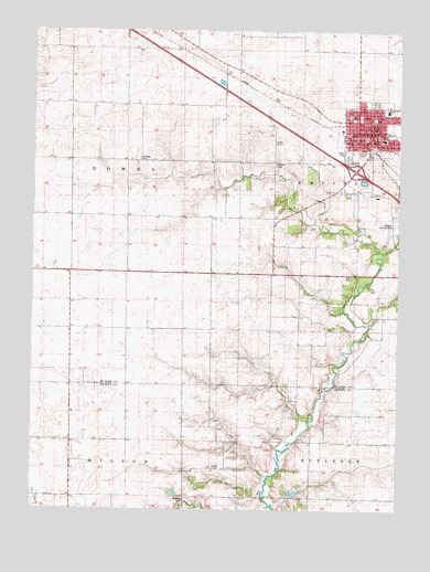
Le Roy, IL USGS Topographic Map
Click on map above to begin viewing in our Map Viewer.

This topographic map contains these locations and features:
Feature Name Type Latitude Longitude GNIS ID View Map
City of Le RoyCivilN40.3394°W88.7629°2395656View Map
Clyde Vance LakeReservoirN40.2842°W88.7733°1691190View Map
Clyde Vance Lake DamDamN40.2817°W88.7734°1691189View Map
Crumbaugh Memorial Public LibraryBuildingN40.3470°W88.7578°1822692View Map
Field School (historical)SchoolN40.3459°W88.7592°408357View Map
Ford WoodsLocaleN40.3634°W88.8098°408498View Map
Gilmore CemeteryCemeteryN40.3402°W88.7926°409031View Map
Imperial School (historical)SchoolN40.2675°W88.8548°410805View Map
Interchange 149CrossingN40.3389°W88.7651°1822510View Map
Le RoyPopulated PlaceN40.3520°W88.7642°411883View Map
Le Roy Elementary SchoolSchoolN40.3545°W88.7542°1822526View Map
Le Roy High SchoolSchoolN40.3467°W88.7553°1725552View Map
Le Roy Junior High SchoolSchoolN40.3467°W88.7559°1822527View Map
Le Roy Post OfficePost OfficeN40.3482°W88.7612°1747599View Map
LeRoy City HallBuildingN40.3464°W88.7615°1822525View Map
LeRoy Community Fire Protection DistrictBuildingN40.3464°W88.7591°2682529View Map
Leroy Emergency Ambulance ServiceBuildingN40.3467°W88.7591°2673946View Map
Long Point CreekStreamN40.3648°W88.7903°424158View Map
Mathews Landing Strip (historical)AirportN40.3239°W88.7517°1747603View Map
Rucker ChapelChurchN40.2611°W88.8131°417024View Map
Rutledge CemeteryCemeteryN40.3416°W88.8387°417081View Map
South Downs School (historical)SchoolN40.2967°W88.8626°418744View Map
Township of DownsCivilN40.3414°W88.8632°428910View Map
Township of WilsonCivilN40.2535°W88.8615°429942View Map
Walden CemeteryCemeteryN40.2527°W88.8232°1748473View Map
Washington School (historical)SchoolN40.3520°W88.7581°420600View Map
West Fork Salt CreekStreamN40.3178°W88.7556°420836View Map

Note: Coordinates in the location and feature list above are referenced to NAD83 datum.


Copyright (C) 2008-2024 Ryan Niemi / Sunset Dynamics ... All Rights Reserved