TopoQuest Logo
Do you find TopoQuest useful?
Help keep TopoQuest running and adding new maps/features by donating!
Bitcoin:  19c7KJd3qBynnjoSw5npx9KScwjBe4ifkT
Litecoin:  LXs6TkuXGGXo1vDsWCkWVdjQX94eUKd6ui
Home View Maps Find Maps Find Places Resources & Links


De Witt, Illinois Topographic Map

USGS Map Title: De Witt, IL
USGS Map MRC: 40088B7
DRG (GeoTIFF) Download: o40088b7.tif


Neighboring USGS Topographic Map Quads:


  Heyworth, IL  
40088C8
 

  Le Roy, IL  
40088C7
 

  Farmer City North, IL  
40088C6
 

  Clinton, IL  
40088B8
 

  De Witt, IL  
40088B7
 

  Farmer City South, IL  
40088B6
 

  Maroa, IL  
40088A8
 

  Weldon West, IL  
40088A7
 

  Weldon East, IL  
40088A6


Map MRC Location:

N41°
W89°
N41°
W88°
H8 H7 H6 H5 H4 H3 H2 H1
G8 G7 G6 G5 G4 G3 G2 G1
F8 F7 F6 F5 F4 F3 F2 F1
E8 E7 E6 E5 E4 E3 E2 E1
D8 D7 D6 D5 D4 D3 D2 D1
C8 C7 C6 C5 C4 C3 C2 C1
B8 B7 B6 B5 B4 B3 B2 B1
A8 A7 A6 A5 A4 A3 A2 A1
N40°
W89°
N40°
W88°

De Witt, IL USGS 1:24K Topographic Map Preview:
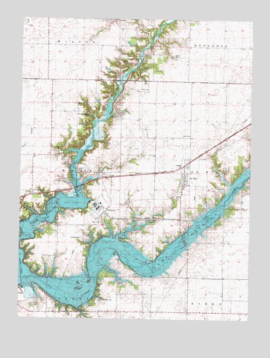
De Witt, IL USGS Topographic Map
Click on map above to begin viewing in our Map Viewer.

This topographic map contains these locations and features:
Feature Name Type Latitude Longitude GNIS ID View Map
BirkbeckPopulated PlaceN40.1770°W88.8684°404465View Map
Camp QuestLocaleN40.1723°W88.8701°1720064View Map
Carter PondReservoirN40.2097°W88.8232°1720061View Map
Centenary ChurchChurchN40.1781°W88.8656°1720063View Map
Clinton Anglers LakesReservoirN40.2100°W88.8376°1720062View Map
Clinton Lake State Recreational AreaParkN40.1856°W88.7528°1808823View Map
Clinton Power Station Fire BrigadeBuildingN40.1734°W88.8253°2682577View Map
De WittPopulated PlaceN40.1811°W88.7862°407024View Map
De Witt CemeteryCemeteryN40.1758°W88.7909°1720060View Map
DeWitt Post OfficePost OfficeN40.1798°W88.7872°2788525View Map
Griffith CemeteryCemeteryN40.1959°W88.8537°409503View Map
Johnson CemeteryCemeteryN40.2347°W88.7928°411158View Map
Lake ClintonReservoirN40.1605°W88.8170°403298View Map
Lake ShinnemanReservoirN40.1329°W88.8306°1720065View Map
Lisenby CemeteryCemeteryN40.1404°W88.8203°412265View Map
North Fork Salt CreekStreamN40.1409°W88.8740°414606View Map
SolomonPopulated PlaceN40.2489°W88.8229°423191View Map
Sugar Hollow RLA AirportAirportN40.1288°W88.8368°2770520View Map
Township of HarpCivilN40.1832°W88.8600°429112View Map
Village of De WittCivilN40.1848°W88.7856°2398697View Map
Walters CemeteryCemeteryN40.2321°W88.8207°420491View Map
Willmore CemeteryCemeteryN40.1654°W88.8747°421279View Map

Note: Coordinates in the location and feature list above are referenced to NAD83 datum.


Copyright (C) 2008-2024 Ryan Niemi / Sunset Dynamics ... All Rights Reserved