TopoQuest Logo
Do you find TopoQuest useful?
Help keep TopoQuest running and adding new maps/features by donating!
Bitcoin:  19c7KJd3qBynnjoSw5npx9KScwjBe4ifkT
Litecoin:  LXs6TkuXGGXo1vDsWCkWVdjQX94eUKd6ui
Home View Maps Find Maps Find Places Resources & Links


Gallup West, New Mexico Topographic Map

USGS Map Title: Gallup West, NM
USGS Map MRC: 35108E7
DRG (GeoTIFF) Download: o35108e7.tif


Neighboring USGS Topographic Map Quads:


  Tse Bonita School, NM  
35108F8
 

  Twin Lakes, NM  
35108F7
 

  Big Rock Hill, NM  
35108F6
 

  Samson Lake, NM  
35108E8
 

  Gallup West, NM  
35108E7
 

  Gallup East, NM  
35108E6
 

  Manuelito, NM  
35108D8
 

  Twin Buttes, NM  
35108D7
 

  Bread Springs, NM  
35108D6


Map MRC Location:

N36°
W109°
N36°
W108°
H8 H7 H6 H5 H4 H3 H2 H1
G8 G7 G6 G5 G4 G3 G2 G1
F8 F7 F6 F5 F4 F3 F2 F1
E8 E7 E6 E5 E4 E3 E2 E1
D8 D7 D6 D5 D4 D3 D2 D1
C8 C7 C6 C5 C4 C3 C2 C1
B8 B7 B6 B5 B4 B3 B2 B1
A8 A7 A6 A5 A4 A3 A2 A1
N35°
W109°
N35°
W108°

Gallup West, NM USGS 1:24K Topographic Map Preview:
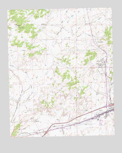
Gallup West, NM USGS Topographic Map
Click on map above to begin viewing in our Map Viewer.

This topographic map contains these locations and features:
Feature Name Type Latitude Longitude GNIS ID View Map
10004 Water WellWellN35.5356°W108.7595°921776View Map
Airport Fire SubstationBuildingN35.5150°W108.7809°2657844View Map
AllisonPopulated PlaceN35.5242°W108.7851°885703View Map
Allison Post Office (historical)Post OfficeN35.5242°W108.7851°937739View Map
American Heritage PlazaLocaleN35.5311°W108.7579°901100View Map
Black Ridge WashStreamN35.6064°W108.8087°886449View Map
Bread Springs WashArroyoN35.5197°W108.8212°904072View Map
Burned Death WashStreamN35.5286°W108.8637°886933View Map
Carbon City MineMineN35.5181°W108.8504°887194View Map
China SpringsSpringN35.5913°W108.7681°902803View Map
Coal BasinBasinN35.5409°W108.7698°887700View Map
Defiance MineMineN35.5272°W108.8529°888308View Map
Enterprise MineMineN35.5256°W108.8270°917559View Map
Free Trinity SchoolSchoolN35.5722°W108.7654°934220View Map
Full Gospel Assemmbly of God ChurchChurchN35.5142°W108.8456°920793View Map
Gallup DivisionCivilN35.5080°W108.7786°1937534View Map
Gallup Fire Department Station 2BuildingN35.5319°W108.7550°2657788View Map
Gallup Medical Flight AmbulanceBuildingN35.5149°W108.7813°2657676View Map
Gallup Municipal AirportAirportN35.5136°W108.7782°936955View Map
Gallup Police DepartmentBuildingN35.5040°W108.8419°2722622View Map
Gallup Post OfficePost OfficeN35.5237°W108.7526°2780904View Map
GamercoPopulated PlaceN35.5722°W108.7654°898781View Map
Gamerco Church of GodChurchN35.5722°W108.7654°917632View Map
Gamerco Post Office (historical)Post OfficeN35.5722°W108.7654°938484View Map
Gamerco WashStreamN35.5259°W108.7573°889314View Map
Gamerco Weather StationLocaleN35.5722°W108.7654°931775View Map
George Coal MineMineN35.5009°W108.7515°917544View Map
Gibson CanyonValleyN35.5492°W108.7556°889399View Map
Gibson Number 4 MineMineN35.5434°W108.8209°917370View Map
Grenko Coal MineMineN35.5042°W108.7906°917534View Map
Hillcrest CemeteryCemeteryN35.5214°W108.7531°890012View Map
Kennedy MineMineN35.5009°W108.7515°917519View Map
Many Arrow WashStreamN35.5886°W108.8220°891589View Map
MC Dermott MineMineN35.5300°W108.7506°917492View Map
McDermott Et Al ProspectMineN35.5231°W108.8445°917500View Map
McKinley West Volunteer Fire DepartmentBuildingN35.5007°W108.8615°2657902View Map
MentmorePopulated PlaceN35.5142°W108.8456°902833View Map
Mentmore Coal MineMineN35.5550°W108.8554°917495View Map
Mentmore Post OfficePost OfficeN35.5142°W108.8456°937512View Map
Munoz 1-A Water WellWellN35.6228°W108.7690°921788View Map
Navajo Number 5MineN35.5000°W108.7506°916921View Map
Navajo Number Five MineMineN35.5720°W108.7629°917564View Map
New MineMineN35.5222°W108.8412°917566View Map
New Mutual Coal MineMineN35.5009°W108.7862°917567View Map
Roat SchoolSchoolN35.5150°W108.7701°894010View Map
Rock Spring Navajo MissionChurchN35.6097°W108.8295°894074View Map
Rock Spring RanchLocaleN35.6097°W108.8637°894075View Map
Rock SpringsPopulated PlaceN35.6095°W108.8293°1852634View Map
Rock Springs Census Designated PlaceCensusN35.6088°W108.8294°2409194View Map
Rock Springs ChapterCivilN35.6242°W108.7743°2419078View Map
Sunset Memorial ParkCemeteryN35.5024°W108.8449°895443View Map
Tietjen ProspectMineN35.5231°W108.8445°914636View Map
Tomada Coal MineMineN35.5014°W108.8398°917556View Map
Twin ButtesPopulated PlaceN35.5045°W108.8473°898860View Map
Twin Buttes WashStreamN35.5036°W108.8623°895942View Map
Washington SchoolSchoolN35.5309°W108.7518°896269View Map
White Smoke WashStreamN35.6067°W108.8095°896531View Map
Winter MineMineN35.5189°W108.7554°917383View Map
Yah-ta-hey Census Designated PlaceCensusN35.6216°W108.7919°2409634View Map

Note: Coordinates in the location and feature list above are referenced to NAD83 datum.


Copyright (C) 2008-2024 Ryan Niemi / Sunset Dynamics ... All Rights Reserved