TopoQuest Logo
Do you find TopoQuest useful?
Help keep TopoQuest running and adding new maps/features by donating!
Bitcoin:  19c7KJd3qBynnjoSw5npx9KScwjBe4ifkT
Litecoin:  LXs6TkuXGGXo1vDsWCkWVdjQX94eUKd6ui
Home View Maps Find Maps Find Places Resources & Links


Big Rock Hill, New Mexico Topographic Map

USGS Map Title: Big Rock Hill, NM
USGS Map MRC: 35108F6
DRG (GeoTIFF) Download: o35108f6.tif


Neighboring USGS Topographic Map Quads:


  Tohatchi, NM  
35108G7
 

  Chuska Lake, NM  
35108G6
 

  Coyote Canyon, NM  
35108G5
 

  Twin Lakes, NM  
35108F7
 

  Big Rock Hill, NM  
35108F6
 

  Hard Ground Flats, NM  
35108F5
 

  Gallup West, NM  
35108E7
 

  Gallup East, NM  
35108E6
 

  Church Rock, NM  
35108E5


Map MRC Location:

N36°
W109°
N36°
W108°
H8 H7 H6 H5 H4 H3 H2 H1
G8 G7 G6 G5 G4 G3 G2 G1
F8 F7 F6 F5 F4 F3 F2 F1
E8 E7 E6 E5 E4 E3 E2 E1
D8 D7 D6 D5 D4 D3 D2 D1
C8 C7 C6 C5 C4 C3 C2 C1
B8 B7 B6 B5 B4 B3 B2 B1
A8 A7 A6 A5 A4 A3 A2 A1
N35°
W109°
N35°
W108°

Big Rock Hill, NM USGS 1:24K Topographic Map Preview:
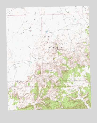
Big Rock Hill, NM USGS Topographic Map
Click on map above to begin viewing in our Map Viewer.

This topographic map contains these locations and features:
Feature Name Type Latitude Longitude GNIS ID View Map
14K-318 Water WellWellN35.6714°W108.7484°922381View Map
14T-306 Water WellWellN35.6892°W108.7445°921805View Map
14T-321 Water WellWellN35.7295°W108.6295°921814View Map
Bass LakeLakeN35.7195°W108.6893°886101View Map
Bethlehem ChurchChurchN35.6536°W108.7443°886278View Map
Big Rock HillRidgeN35.6714°W108.6848°886324View Map
Coal Mine HillRidgeN35.7031°W108.6392°887708View Map
Coal Mine SpringSpringN35.6952°W108.6482°887710View Map
ERC 17-1 Water WellWellN35.7078°W108.6654°933112View Map
Figuredo WashStreamN35.7414°W108.7059°889028View Map
Jack JohnsonMineN35.6820°W108.6815°917525View Map
Jack Johnson MineMineN35.6817°W108.6818°890384View Map
Mexican Cooking CanyonValleyN35.7481°W108.6323°891920View Map
Sheep SpringSpringN35.6975°W108.6731°894779View Map
Sheep Spring HillRidgeN35.6964°W108.6748°894781View Map
State Pit 63-4-5MineN35.6334°W108.6340°917372View Map
Tohasged SpringSpringN35.6889°W108.6423°897540View Map
Tohatchie MineMineN35.6909°W108.6295°914639View Map
Tom RanchLocaleN35.6478°W108.6567°895737View Map
Woolly Tommy MineMineN35.6806°W108.6865°896770View Map

Note: Coordinates in the location and feature list above are referenced to NAD83 datum.


Copyright (C) 2008-2024 Ryan Niemi / Sunset Dynamics ... All Rights Reserved