TopoQuest Logo
Do you find TopoQuest useful?
Help keep TopoQuest running and adding new maps/features by donating!
Bitcoin:  19c7KJd3qBynnjoSw5npx9KScwjBe4ifkT
Litecoin:  LXs6TkuXGGXo1vDsWCkWVdjQX94eUKd6ui
Home View Maps Find Maps Find Places Resources & Links


Girard, Kansas Topographic Map

USGS Map Title: Girard, KS
USGS Map MRC: 37094E7
DRG (GeoTIFF) Download: o37094e7.tif


Neighboring USGS Topographic Map Quads:


  Hepler, KS  
37094F8
 

  Hiattville, KS  
37094F7
 

  Cato, KS  
37094F6
 

  Brazilton, KS  
37094E8
 

  Girard, KS  
37094E7
 

  Arma, KS  
37094E6
 

  Grindstone Creek, KS  
37094D8
 

  Radley, KS  
37094D7
 

  Pittsburg, KS  
37094D6


Map MRC Location:

N38°
W95°
N38°
W94°
H8 H7 H6 H5 H4 H3 H2 H1
G8 G7 G6 G5 G4 G3 G2 G1
F8 F7 F6 F5 F4 F3 F2 F1
E8 E7 E6 E5 E4 E3 E2 E1
D8 D7 D6 D5 D4 D3 D2 D1
C8 C7 C6 C5 C4 C3 C2 C1
B8 B7 B6 B5 B4 B3 B2 B1
A8 A7 A6 A5 A4 A3 A2 A1
N37°
W95°
N37°
W94°

Girard, KS USGS 1:24K Topographic Map Preview:
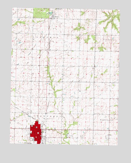
Girard, KS USGS Topographic Map
Click on map above to begin viewing in our Map Viewer.

This topographic map contains these locations and features:
Feature Name Type Latitude Longitude GNIS ID View Map
Bethany School (historical)SchoolN37.5548°W94.8425°483498View Map
Calvary Bible ChurchChurchN37.5168°W94.8540°2690827View Map
City of GirardCivilN37.5092°W94.8458°485582View Map
Clear CreekStreamN37.5123°W94.8091°475141View Map
Crawford CountyCivilN37.5073°W94.8518°484988View Map
Crawford County CourthouseBuildingN37.5101°W94.8426°2625085View Map
Crawford County FairgroundsLocaleN37.5094°W94.8085°2692992View Map
Crawford County JailBuildingN37.5124°W94.8647°2504299View Map
Crawford County Rural Fire District 4BuildingN37.5135°W94.8606°2111242View Map
Crawford County Rural Fire District 4 Station 2BuildingN37.5139°W94.8134°2111243View Map
Crawford County Sheriff's OfficeBuildingN37.5123°W94.8645°2503937View Map
FarlingtonPopulated PlaceN37.6178°W94.8277°475139View Map
Farlington United Methodist ChurchChurchN37.6171°W94.8274°2689410View Map
First Baptist ChurchChurchN37.5111°W94.8455°2688977View Map
First Christian ChurchChurchN37.5119°W94.8439°2690841View Map
First Presbyterian ChurchChurchN37.5124°W94.8432°2689020View Map
Frisco LakeReservoirN37.6206°W94.8304°475140View Map
Garfield School (historical)SchoolN37.6156°W94.7777°483513View Map
GirardPopulated PlaceN37.5112°W94.8380°469732View Map
Girard Bible ChurchChurchN37.5216°W94.8459°2689746View Map
Girard CemeteryCemeteryN37.5002°W94.8533°469731View Map
Girard City HallBuildingN37.5111°W94.8415°2693343View Map
Girard Civic CenterBuildingN37.5084°W94.8421°2692906View Map
Girard Fire DepartmentBuildingN37.5114°W94.8412°2111361View Map
Girard High SchoolSchoolN37.5151°W94.8439°481017View Map
Girard Juvenile Detention CenterBuildingN37.5132°W94.8635°2754342View Map
Girard Medical CenterHospitalN37.5146°W94.8579°2499150View Map
Girard Medical Center HeliportAirportN37.5155°W94.8578°2624887View Map
Girard Middle SchoolSchoolN37.5147°W94.8439°2437475View Map
Girard Municipal Golf CourseLocaleN37.5094°W94.8135°2694563View Map
Girard Municipal Power PlantLocaleN37.5075°W94.8389°2692431View Map
Girard Police DepartmentBuildingN37.5111°W94.8415°2504066View Map
Girard Post OfficePost OfficeN37.5116°W94.8438°2693737View Map
Girard Public LibraryBuildingN37.5099°W94.8449°2694644View Map
Girard United Methodist ChurchChurchN37.5084°W94.8438°2689428View Map
Girard Wastewater Treatment FacilityLocaleN37.5013°W94.8580°2692017View Map
Gunn School (historical)SchoolN37.6164°W94.8691°483518View Map
Hadley (historical)LocaleN37.5723°W94.7505°482118View Map
Harvest Time Holiness ChurchChurchN37.5047°W94.8439°2689067View Map
Living Faith Church of the NazareneChurchN37.5144°W94.7581°2689107View Map
Lone Elm School (historical)SchoolN37.5723°W94.7789°483533View Map
Museum of Crawford CountyBuildingN37.5080°W94.8431°2694268View Map
Ozark School (historical)SchoolN37.6014°W94.8147°483550View Map
Ozark School (historical)SchoolN37.5434°W94.7783°483551View Map
Prairie Bell School (historical)SchoolN37.5720°W94.8183°483559View Map
Prairie View School (historical)SchoolN37.5428°W94.8152°483560View Map
Producers Co - Operative Association Grain Elevator Number 2LocaleN37.5436°W94.8455°2695297View Map
R. V. Haderlein Elementary SchoolSchoolN37.5100°W94.8511°481018View Map
RingoPopulated PlaceN37.5095°W94.7614°475142View Map
Saint Michael's Catholic ChurchChurchN37.5113°W94.8512°2690864View Map
Second Valley School (historical)SchoolN37.6014°W94.7552°483565View Map
Sherman Township Fire DepartmentBuildingN37.6156°W94.8286°2111886View Map
Township of CrawfordCivilN37.5065°W94.8609°469730View Map
Township of ShermanCivilN37.6162°W94.8600°474998View Map
Trinity Lutheran ChurchChurchN37.5135°W94.8447°2689237View Map
Union Center CemeteryCemeteryN37.5292°W94.7778°475138View Map
Winston ParkParkN37.5048°W94.8469°475137View Map
Ziggy Carline AirportAirportN37.5045°W94.8273°2675718View Map

Note: Coordinates in the location and feature list above are referenced to NAD83 datum.


Copyright (C) 2008-2024 Ryan Niemi / Sunset Dynamics ... All Rights Reserved