TopoQuest Logo
Do you find TopoQuest useful?
Help keep TopoQuest running and adding new maps/features by donating!
Bitcoin:  19c7KJd3qBynnjoSw5npx9KScwjBe4ifkT
Litecoin:  LXs6TkuXGGXo1vDsWCkWVdjQX94eUKd6ui
Home View Maps Find Maps Find Places Resources & Links


Hartleton, Pennsylvania Topographic Map

USGS Map Title: Hartleton, PA
USGS Map MRC: 40077H2
DRG (GeoTIFF) Download: o40077h2.tif


Neighboring USGS Topographic Map Quads:


  Loganton, PA  
41077A3
 

  Carroll, PA  
41077A2
 

  Williamsport SE, PA  
41077A1
 

  Woodward, PA  
40077H3
 

  Hartleton, PA  
40077H2
 

  Mifflinburg, PA  
40077H1
 

  Weikert, PA  
40077G3
 

  Beavertown, PA  
40077G2
 

  Middleburg, PA  
40077G1


Map MRC Location:

N41°
W78°
N41°
W77°
H8 H7 H6 H5 H4 H3 H2 H1
G8 G7 G6 G5 G4 G3 G2 G1
F8 F7 F6 F5 F4 F3 F2 F1
E8 E7 E6 E5 E4 E3 E2 E1
D8 D7 D6 D5 D4 D3 D2 D1
C8 C7 C6 C5 C4 C3 C2 C1
B8 B7 B6 B5 B4 B3 B2 B1
A8 A7 A6 A5 A4 A3 A2 A1
N40°
W78°
N40°
W77°

Hartleton, PA USGS 1:24K Topographic Map Preview:
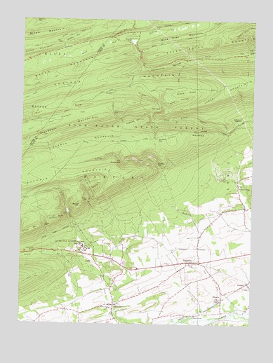
Hartleton, PA USGS Topographic Map
Click on map above to begin viewing in our Map Viewer.

This topographic map contains these locations and features:
Feature Name Type Latitude Longitude GNIS ID View Map
Bake Oven MountainSummitN40.9923°W77.1702°1168591View Map
Baker PathTrailN40.9820°W77.1283°1168604View Map
Bartley GapGapN40.9267°W77.2130°1168777View Map
Bartley MountainSummitN40.9234°W77.2178°1168778View Map
Bartley RunStreamN40.9034°W77.1908°1168779View Map
Boiling SpringSpringN40.9987°W77.1800°1202374View Map
Borough of HartletonCivilN40.9002°W77.1564°1215631View Map
Branch MountainSummitN40.9406°W77.2491°1170153View Map
Brocher PathTrailN40.9573°W77.2197°1206929View Map
Buck RidgeRidgeN40.9662°W77.1897°1170535View Map
Buffalo GapGapN40.9409°W77.1764°1170605View Map
Buffalo PathTrailN40.9767°W77.1380°1170613View Map
Cold RunStreamN40.8812°W77.1344°1172150View Map
Cranberry FlatFlatN40.9626°W77.2125°1172619View Map
Cranberry GapGapN40.9623°W77.2002°1172620View Map
Dogback MountainSummitN40.9595°W77.1847°1173347View Map
Douty Mill TrailTrailN40.8879°W77.2430°1206928View Map
Dug TrailTrailN40.9531°W77.2405°1206930View Map
Fourteenmile NarrowsGapN40.9812°W77.1714°1175068View Map
Frederick GapGapN40.9995°W77.2436°1175190View Map
Frederick TrailTrailN40.9473°W77.1994°1175191View Map
Fredricks TrailTrailN40.9976°W77.2372°1206945View Map
Halfway DamDamN40.9901°W77.1897°1207382View Map
Halfway LakeLakeN40.9910°W77.1903°1176389View Map
Halfway RunStreamN40.9915°W77.1877°1176390View Map
HartletonPopulated PlaceN40.9006°W77.1561°1176604View Map
Hartleton CemeteryCemeteryN40.8998°W77.1672°1176605View Map
Hartleton Post OfficePost OfficeN40.9015°W77.1530°2780045View Map
Hayes Mill TrailTrailN40.9406°W77.2328°1176688View Map
Hickernell SpringSpringN40.9048°W77.2419°1176941View Map
Ice SpringSpringN40.9584°W77.1780°1177676View Map
Jones MountainSummitN40.9745°W77.1389°1178151View Map
LaureltonPopulated PlaceN40.8831°W77.1986°1179033View Map
Laurelton Census Designated PlaceCensusN40.8815°W77.2024°2584478View Map
Laurelton Post OfficePost OfficeN40.8826°W77.1988°2779839View Map
Laurelton State VillageLocaleN40.9070°W77.2150°1179034View Map
Laurelton State Village FarmsLocaleN40.8826°W77.1880°1212573View Map
Lincoln ParkParkN40.8892°W77.1991°1179377View Map
Little MountainSummitN40.9506°W77.1691°1179607View Map
Lookout TrailTrailN40.9381°W77.1861°1179934View Map
McCall FieldParkN40.9942°W77.2147°1197840View Map
McCall MountainSummitN40.9928°W77.2469°1180609View Map
Middle RidgeRidgeN40.9706°W77.1608°1181044View Map
Middle Ridge TrailTrailN40.9795°W77.1639°1181052View Map
Mifflinburg ReservoirReservoirN40.9591°W77.1308°1181092View Map
MillmontPopulated PlaceN40.8859°W77.1408°1181274View Map
Millmont Post OfficePost OfficeN40.8862°W77.1403°2780044View Map
Molasses GapGapN40.9506°W77.1755°1181403View Map
Molasses Gap TrailTrailN40.9467°W77.1739°1206932View Map
Mount Luther CampLocaleN40.9351°W77.1394°1181744View Map
Old Cedars CemeteryCemeteryN40.8898°W77.1255°1182903View Map
Oley Camp TrailTrailN40.9817°W77.2314°1206927View Map
Panther RunStreamN40.9612°W77.1797°1183261View Map
Park Bake Oven TrailTrailN40.9934°W77.1594°1206925View Map
Park OverlookLocaleN40.9967°W77.1922°1207391View Map
Pennsylvania Department of Conservation and Natural Resources District 7 Bold Eagle DivisionBuildingN40.9022°W77.2132°2653043View Map
Pleasant GrovePopulated PlaceN40.9326°W77.1325°1184012View Map
Pleasant Grove ChurchChurchN40.9323°W77.1322°1197295View Map
Rapid Run GapGapN40.9848°W77.1869°1202375View Map
Raymond B Winter State ParkParkN40.9942°W77.1897°1184726View Map
Rock Oak Park (historical)ParkN40.9026°W77.1339°1197296View Map
Seven Notch MountainSummitN40.9856°W77.1780°1187261View Map
Slide HollowValleyN40.9653°W77.1750°1187806View Map
Spruce RunStreamN40.8895°W77.1953°1188347View Map
Stitzer GapGapN40.9154°W77.2369°1188690View Map
Stitzer MountainSummitN40.9134°W77.2439°1188691View Map
Stone MountainSummitN40.9184°W77.2297°1188728View Map
Stony RunStreamN40.8945°W77.2022°1188790View Map
Stony Run DamDamN40.9201°W77.2247°1195149View Map
SwengelPopulated PlaceN40.8923°W77.1266°1189178View Map
The GooseneckBendN40.9415°W77.1950°1189402View Map
The HookBendN40.9637°W77.1741°1189408View Map
The Little BubblerSpringN40.9923°W77.1922°1202362View Map
Township of HartleyCivilN40.8969°W77.2332°1217131View Map
Township of LewisCivilN40.9593°W77.1277°1217133View Map
Union ChurchChurchN40.8992°W77.1564°1190142View Map
Western Area SchoolSchoolN40.8817°W77.2003°1191144View Map
Yankee RunStreamN40.9854°W77.2255°1191857View Map
Yankee Run TrailTrailN40.9695°W77.2222°1206926View Map

Note: Coordinates in the location and feature list above are referenced to NAD83 datum.


Copyright (C) 2008-2024 Ryan Niemi / Sunset Dynamics ... All Rights Reserved