TopoQuest Logo
Do you find TopoQuest useful?
Help keep TopoQuest running and adding new maps/features by donating!
Bitcoin:  19c7KJd3qBynnjoSw5npx9KScwjBe4ifkT
Litecoin:  LXs6TkuXGGXo1vDsWCkWVdjQX94eUKd6ui
Home View Maps Find Maps Find Places Resources & Links


Watertown, Tennessee Topographic Map

USGS Map Title: Watertown, TN
USGS Map MRC: 36086A2
DRG (GeoTIFF) Download: o36086a2.tif


Neighboring USGS Topographic Map Quads:


  Lebanon, TN  
36086B3
 

  Shop Springs, TN  
36086B2
 

  New Middleton, TN  
36086B1
 

  Vine, TN  
36086A3
 

  Watertown, TN  
36086A2
 

  Alexandria, TN  
36086A1
 

  Lascassas, TN  
35086H3
 

  Milton, TN  
35086H2
 

  Auburntown, TN  
35086H1


Map MRC Location:

N37°
W87°
N37°
W86°
H8 H7 H6 H5 H4 H3 H2 H1
G8 G7 G6 G5 G4 G3 G2 G1
F8 F7 F6 F5 F4 F3 F2 F1
E8 E7 E6 E5 E4 E3 E2 E1
D8 D7 D6 D5 D4 D3 D2 D1
C8 C7 C6 C5 C4 C3 C2 C1
B8 B7 B6 B5 B4 B3 B2 B1
A8 A7 A6 A5 A4 A3 A2 A1
N36°
W87°
N36°
W86°

Watertown, TN USGS 1:24K Topographic Map Preview:
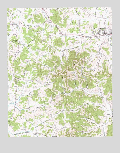
Watertown, TN USGS Topographic Map
Click on map above to begin viewing in our Map Viewer.

This topographic map contains these locations and features:
Feature Name Type Latitude Longitude GNIS ID View Map
Beech Log CreekStreamN36.0978°W86.1305°1276853View Map
Bug HollowValleyN36.0470°W86.1668°1278930View Map
Center Hill (historical)Populated PlaceN36.1084°W86.2325°1312821View Map
Cherry ValleyPopulated PlaceN36.0984°W86.1639°1305881View Map
City of WatertownCivilN36.1010°W86.1402°2405686View Map
Doaks CrossroadsPopulated PlaceN36.1089°W86.2436°1314951View Map
Dry BranchStreamN36.1178°W86.2361°1282854View Map
Fairview CemeteryCemeteryN36.0551°W86.2392°1283994View Map
Fall Creek ChurchChurchN36.0523°W86.2400°1284077View Map
Goose CreekStreamN36.0051°W86.2217°1285669View Map
Greenvale Baptist ChurchChurchN36.0006°W86.2008°1323180View Map
Greenvale CemeteryCemeteryN36.0089°W86.1972°1286185View Map
Griffin CemeteryCemeteryN36.0670°W86.1614°1286265View Map
Griffin HollowValleyN36.0424°W86.1813°1286271View Map
Jennings CemeteryCemeteryN36.0189°W86.1325°1289379View Map
Johnson HollowValleyN36.0090°W86.1432°1289615View Map
Jones CemeteryCemeteryN36.0914°W86.1450°1289743View Map
Jug CreekStreamN36.0328°W86.2436°1289873View Map
Knight CreekStreamN36.0101°W86.1361°1290367View Map
Massey CemeteryCemeteryN36.0978°W86.1980°1292908View Map
Middle Fork Spring CreekStreamN36.1078°W86.2380°1293678View Map
Mount DefianceSummitN36.0742°W86.1619°1282310View Map
Mount Olive Church (historical)ChurchN36.0795°W86.1369°1323223View Map
Mount VernonPopulated PlaceN36.0409°W86.1375°1312872View Map
Mount Vernon ChurchChurchN36.0370°W86.1372°1294829View Map
Neal BranchStreamN36.0967°W86.1311°1295272View Map
Neal CemeteryCemeteryN36.0953°W86.1272°1295279View Map
NorenePopulated PlaceN36.0567°W86.2425°1295814View Map
Norene Post OfficePost OfficeN36.0569°W86.2421°2766117View Map
Norene SchoolSchoolN36.0492°W86.2394°1295815View Map
Patton HollowValleyN36.0791°W86.1366°1296983View Map
Pemberton BranchStreamN36.0903°W86.2308°1297129View Map
Ramah ChurchChurchN36.0423°W86.1861°1298866View Map
Robinson CemeteryCemeteryN36.0592°W86.2311°1299694View Map
Rocky BranchStreamN36.0231°W86.1264°1299862View Map
SherrilltownPopulated PlaceN36.0489°W86.2028°1314276View Map
Smith Fork ChurchChurchN36.0123°W86.1350°1303680View Map
Smith HollowValleyN36.0447°W86.1563°1270686View Map
Spring Creek ChurchChurchN36.0928°W86.2389°1303760View Map
Sunset CreekStreamN36.0103°W86.1361°1271883View Map
Thompson CemeteryCemeteryN36.0923°W86.2364°1272525View Map
Waters CemeteryCemeteryN36.1042°W86.1253°1273899View Map
WatertownPopulated PlaceN36.1003°W86.1319°1304411View Map
Watertown Church of ChristChurchN36.1020°W86.1347°1323271View Map
Watertown Division (historical)CensusN36.0703°W86.1394°1649032View Map
Watertown Elementary SchoolSchoolN36.0992°W86.1417°1323272View Map
Watertown High SchoolSchoolN36.0998°W86.1411°1323273View Map
Watertown Junior High SchoolSchoolN36.0984°W86.1478°1323274View Map
Watertown Police DepartmentBuildingN36.0967°W86.1397°2765856View Map
Watertown Post OfficePost OfficeN36.0997°W86.1296°1652057View Map
Watertown Volunteer Fire DepartmentBuildingN36.1004°W86.1317°2653765View Map
West Fork Spring CreekStreamN36.1234°W86.2386°1274193View Map
Williams BranchStreamN36.0048°W86.2214°1274634View Map
Williams CemeteryCemeteryN36.0367°W86.2405°1274665View Map
Williams CemeteryCemeteryN36.1084°W86.1933°1274667View Map
Wilson Emergency Management Agency Station 2 WatertownBuildingN36.1003°W86.1333°2653838View Map
Wilson Emergency Management Agency Station 7 StatesvilleBuildingN36.0182°W86.1301°2654186View Map

Note: Coordinates in the location and feature list above are referenced to NAD83 datum.


Copyright (C) 2008-2024 Ryan Niemi / Sunset Dynamics ... All Rights Reserved