TopoQuest Logo
Do you find TopoQuest useful?
Help keep TopoQuest running and adding new maps/features by donating!
Bitcoin:  19c7KJd3qBynnjoSw5npx9KScwjBe4ifkT
Litecoin:  LXs6TkuXGGXo1vDsWCkWVdjQX94eUKd6ui
Home View Maps Find Maps Find Places Resources & Links


Mansfield, Tennessee Topographic Map

USGS Map Title: Mansfield, TN
USGS Map MRC: 36088B3
DRG (GeoTIFF) Download: o36088b3.tif


Neighboring USGS Topographic Map Quads:


  Osage, TN  
36088C4
 

  Paris, TN  
36088C3
 

  West Sandy Dike, TN  
36088C2
 

  Henry, TN  
36088B4
 

  Mansfield, TN  
36088B3
 

  Manleyville, TN  
36088B2
 

  Huntingdon, TN  
36088A4
 

  Vale, TN  
36088A3
 

  Bruceton, TN  
36088A2


Map MRC Location:

N37°
W89°
N37°
W88°
H8 H7 H6 H5 H4 H3 H2 H1
G8 G7 G6 G5 G4 G3 G2 G1
F8 F7 F6 F5 F4 F3 F2 F1
E8 E7 E6 E5 E4 E3 E2 E1
D8 D7 D6 D5 D4 D3 D2 D1
C8 C7 C6 C5 C4 C3 C2 C1
B8 B7 B6 B5 B4 B3 B2 B1
A8 A7 A6 A5 A4 A3 A2 A1
N36°
W89°
N36°
W88°

Mansfield, TN USGS 1:24K Topographic Map Preview:
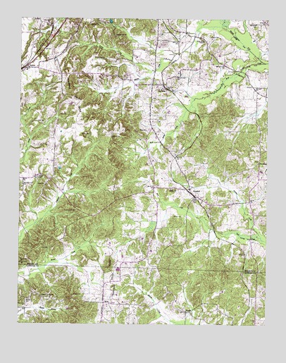
Mansfield, TN USGS Topographic Map
Click on map above to begin viewing in our Map Viewer.

This topographic map contains these locations and features:
Feature Name Type Latitude Longitude GNIS ID View Map
Allen Store (historical)LocaleN36.2356°W88.2787°1317279View Map
Babb CemeteryCemeteryN36.2256°W88.2628°1325979View Map
Barnes ForkStreamN36.2320°W88.2517°1304963View Map
Bomar CemeteryCemeteryN36.1645°W88.2584°1325987View Map
Bomar CreekStreamN36.2287°W88.3070°1277920View Map
Broach CemeteryCemeteryN36.1692°W88.2967°1278429View Map
Bunn School (historical)SchoolN36.1826°W88.3609°1317296View Map
Carter CemeteryCemeteryN36.2281°W88.2781°1279804View Map
Carter CemeteryCemeteryN36.2028°W88.2675°1326006View Map
Carter CemeteryCemeteryN36.2334°W88.3662°1326007View Map
Cates CemeteryCemeteryN36.2106°W88.3548°1279882View Map
Claxton CemeteryCemeteryN36.2423°W88.2789°1280621View Map
Cobb CemeteryCemeteryN36.1820°W88.3617°1280821View Map
Cochran Grove School (historical)SchoolN36.1634°W88.3064°1317305View Map
Commissioner District 2CivilN36.2130°W88.3260°2463933View Map
Dickson Grove ChurchChurchN36.1367°W88.3634°1282459View Map
District 10 (historical)CivilN36.1292°W88.3167°1325883View Map
Dumpling Hill CemeteryCemeteryN36.1717°W88.3467°1306401View Map
Dumpling Hill Church (historical)ChurchN36.1717°W88.3475°1317313View Map
EphesusPopulated PlaceN36.1303°W88.2887°1315022View Map
Ephesus Baptist ChurchChurchN36.1303°W88.2903°1645043View Map
Ephesus CemeteryCemeteryN36.1301°W88.2911°1326660View Map
Ephesus School (historical)SchoolN36.1301°W88.2920°1320324View Map
Eureka School (historical)SchoolN36.2326°W88.2834°1317317View Map
Greenbriar CreekStreamN36.2448°W88.2614°1269606View Map
Greer CemeteryCemeteryN36.2076°W88.3662°1286217View Map
Haglerville (historical)Populated PlaceN36.1673°W88.3459°1310776View Map
Haglerville CemeteryCemeteryN36.1581°W88.3559°1326040View Map
Harman CemeteryCemeteryN36.2342°W88.3339°1326041View Map
Harrison CemeteryCemeteryN36.2351°W88.3045°1326042View Map
Hatman CemeteryCemeteryN36.2339°W88.3331°1287148View Map
Hinchey CemeteryCemeteryN36.2467°W88.3389°1287864View Map
Hollands Store (historical)LocaleN36.2448°W88.2948°1317332View Map
Joyner CemeteryCemeteryN36.1559°W88.3637°1289861View Map
Kelly CemeteryCemeteryN36.1637°W88.2792°1326054View Map
Key CemeteryCemeteryN36.2226°W88.2581°1290124View Map
Little Rock ChurchChurchN36.2409°W88.2817°1291645View Map
MansfieldPopulated PlaceN36.1773°W88.2862°1292594View Map
Mansfield Baptist ChurchChurchN36.1773°W88.2845°1644939View Map
Mansfield CemeteryCemeteryN36.1748°W88.2789°1326066View Map
Mansfield Fire DepartmentBuildingN36.1770°W88.2833°2653782View Map
Mansfield Post OfficePost OfficeN36.1799°W88.2892°1650798View Map
Mansfield School (historical)SchoolN36.1737°W88.2775°1317347View Map
McBride CemeteryCemeteryN36.1351°W88.3698°1293089View Map
MixiePopulated PlaceN36.1339°W88.3317°1315525View Map
Mixie Baptist ChurchChurchN36.1364°W88.3317°1326669View Map
Morphis School (historical)SchoolN36.1584°W88.3559°1317355View Map
Muzzall CemeteryCemeteryN36.1614°W88.2745°1326082View Map
New HopePopulated PlaceN36.1917°W88.2539°1315592View Map
New Hope CemeteryCemeteryN36.1920°W88.2545°1326088View Map
New Hope ChurchChurchN36.1920°W88.2539°1317365View Map
New Hope School (historical)SchoolN36.1906°W88.2553°1317366View Map
Palmer CemeteryCemeteryN36.2042°W88.3103°1296694View Map
Panther CreekStreamN36.1598°W88.2520°1296740View Map
Patterson CemeteryCemeteryN36.2484°W88.3739°1326106View Map
Peeples CemeteryCemeteryN36.1856°W88.3645°1297117View Map
Perry CemeteryCemeteryN36.1834°W88.3123°1326107View Map
Pettijohn CreekStreamN36.1662°W88.3662°1304752View Map
Quillens Store (historical)LocaleN36.2226°W88.2578°1317403View Map
Ray BridgeBridgeN36.2289°W88.2639°1317404View Map
RoutonPopulated PlaceN36.2295°W88.3723°1300191View Map
Shepard CemeteryCemeteryN36.1373°W88.3473°1270033View Map
Shiloh CemeteryCemeteryN36.1809°W88.2978°1326125View Map
Shiloh ChurchChurchN36.1806°W88.2984°1303588View Map
Spring Hill CemeteryCemeteryN36.2426°W88.3273°1326128View Map
Spring Hill School (historical)SchoolN36.2437°W88.3284°1317421View Map
Springhill Baptist ChurchChurchN36.2426°W88.3264°1303768View Map
Swindall School (historical)SchoolN36.1256°W88.3634°1320374View Map
Union Grove ChurchChurchN36.2170°W88.3084°1317430View Map
Union Grove School (historical)SchoolN36.2164°W88.3084°1317431View Map
Van DykePopulated PlaceN36.2214°W88.3012°1314449View Map
Van Dyke School (historical)SchoolN36.2228°W88.3081°1317433View Map
Vandyke CemeteryCemeteryN36.2176°W88.3084°1326150View Map
Walton CemeteryCemeteryN36.2026°W88.3434°1273755View Map
Whitehead CemeteryCemeteryN36.2476°W88.2520°1274412View Map

Note: Coordinates in the location and feature list above are referenced to NAD83 datum.


Copyright (C) 2008-2024 Ryan Niemi / Sunset Dynamics ... All Rights Reserved