TopoQuest Logo
Do you find TopoQuest useful?
Help keep TopoQuest running and adding new maps/features by donating!
Bitcoin:  19c7KJd3qBynnjoSw5npx9KScwjBe4ifkT
Litecoin:  LXs6TkuXGGXo1vDsWCkWVdjQX94eUKd6ui
Home View Maps Find Maps Find Places Resources & Links


Osage, Tennessee Topographic Map

USGS Map Title: Osage, TN
USGS Map MRC: 36088C4
DRG (GeoTIFF) Download: o36088c4.tif


Neighboring USGS Topographic Map Quads:


  Palmersville, TN  
36088D5
 

  Cottage Grove, TN  
36088D4
 

  Puryear, TN  
36088D3
 

  Como, TN  
36088C5
 

  Osage, TN  
36088C4
 

  Paris, TN  
36088C3
 

  McKenzie, TN  
36088B5
 

  Henry, TN  
36088B4
 

  Mansfield, TN  
36088B3


Map MRC Location:

N37°
W89°
N37°
W88°
H8 H7 H6 H5 H4 H3 H2 H1
G8 G7 G6 G5 G4 G3 G2 G1
F8 F7 F6 F5 F4 F3 F2 F1
E8 E7 E6 E5 E4 E3 E2 E1
D8 D7 D6 D5 D4 D3 D2 D1
C8 C7 C6 C5 C4 C3 C2 C1
B8 B7 B6 B5 B4 B3 B2 B1
A8 A7 A6 A5 A4 A3 A2 A1
N36°
W89°
N36°
W88°

Osage, TN USGS 1:24K Topographic Map Preview:
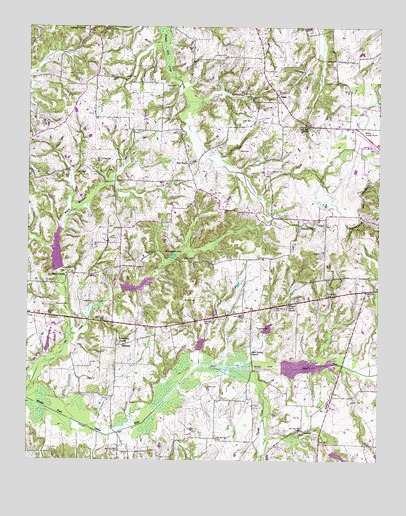
Osage, TN USGS Topographic Map
Click on map above to begin viewing in our Map Viewer.

This topographic map contains these locations and features:
Feature Name Type Latitude Longitude GNIS ID View Map
Alexander CemeteryCemeteryN36.3301°W88.4612°1325973View Map
Alexander CemeteryCemeteryN36.2870°W88.3834°1325974View Map
Barris Chapel School (historical)SchoolN36.3037°W88.4862°1317282View Map
Barrs Chapel CemeteryCemeteryN36.3039°W88.4864°1325980View Map
Barrs Chapel Christian Methodist Episcopal ChurchChurchN36.3031°W88.4864°1276392View Map
Bowden CemeteryCemeteryN36.3273°W88.4373°1325992View Map
Briarpatch LakeLakeN36.3089°W88.4478°1278319View Map
Central Point Baptist ChurchChurchN36.2953°W88.4042°1644933View Map
Central Point School (historical)SchoolN36.2953°W88.4039°1317301View Map
Coley CemeteryCemeteryN36.3606°W88.4659°1280961View Map
Cottage Grove Division (historical)CensusN36.3553°W88.4595°1648778View Map
Cottage Grove Volunteer Fire DepartmentBuildingN36.3748°W88.4794°2653727View Map
Dumas CemeteryCemeteryN36.3367°W88.4745°1283126View Map
Edwards CemeteryCemeteryN36.3095°W88.4584°1326030View Map
Elbethel School (historical)SchoolN36.3659°W88.4170°1317316View Map
Flood Water Retarding Dam Number OneDamN36.3084°W88.4900°1302495View Map
Friendship ChurchChurchN36.2839°W88.4670°1284943View Map
Gum Spring ChurchChurchN36.2812°W88.4203°1286424View Map
Hancel CemeteryCemeteryN36.3051°W88.4839°1286714View Map
HearndalePopulated PlaceN36.2531°W88.4673°1310779View Map
Henry County AirportAirportN36.3403°W88.3800°1301416View Map
Howard CemeteryCemeteryN36.3428°W88.4284°1326044View Map
Janes CemeteryCemeteryN36.3398°W88.4253°1289297View Map
Johnson ChapelChurchN36.3173°W88.4034°1289587View Map
Johnson Chapel CemeteryCemeteryN36.3164°W88.4034°1326051View Map
Jones CemeteryCemeteryN36.3334°W88.4798°1289755View Map
Lampkins CemeteryCemeteryN36.3670°W88.4345°1290562View Map
Lebanon Church (historical)ChurchN36.3112°W88.4534°1317340View Map
Leoney CemeteryCemeteryN36.2673°W88.3845°1291036View Map
Lewis CemeteryCemeteryN36.2923°W88.4237°1291074View Map
Lumbix CemeteryCemeteryN36.2953°W88.4764°1292271View Map
McCall CemeteryCemeteryN36.3337°W88.4134°1293106View Map
Middle Fork Obion Dam FiveDamN36.2767°W88.4084°1302467View Map
Middle Fork Obion Lake FiveReservoirN36.2772°W88.4010°1302466View Map
Middle Fork Obion River Dam Number FourDamN36.2871°W88.4162°1302472View Map
Middle Fork Obion River Dam Number SixDamN36.2534°W88.3917°1302448View Map
Middle Fork Obion River Dam Number ThreeDamN36.2817°W88.4384°1302469View Map
Middle Fork Obion River Dam Number TwoDamN36.2997°W88.4667°1302484View Map
Middle Fork Obion River Lake Number FourReservoirN36.2881°W88.4145°1302473View Map
Middle Fork Obion River Lake Number SixReservoirN36.2516°W88.3892°1302449View Map
Middle Fork Obion River Lake Number ThreeReservoirN36.2836°W88.4383°1302468View Map
Middle Fork Obion River Lake Number TwoReservoirN36.3002°W88.4616°1302485View Map
MidwayPopulated PlaceN36.2837°W88.4656°1315502View Map
Milton Grove ChurchChurchN36.2956°W88.4070°1294016View Map
Morrow CemeteryCemeteryN36.2962°W88.4445°1306767View Map
New BostonPopulated PlaceN36.3362°W88.4431°1315583View Map
New Boston CemeteryCemeteryN36.3362°W88.4420°1326087View Map
New Boston School (historical)SchoolN36.3356°W88.4428°1317364View Map
Nichols School (historical)SchoolN36.3453°W88.4942°1317367View Map
Oak Hall School (historical)SchoolN36.2548°W88.3956°1317373View Map
Oak Hill CemeteryCemeteryN36.3462°W88.4003°1326093View Map
Oak Hill ChurchChurchN36.3464°W88.4006°1306848View Map
Olive CemeteryCemeteryN36.3581°W88.4512°1296409View Map
OsagePopulated PlaceN36.3559°W88.4117°1296500View Map
Osage School (historical)SchoolN36.3542°W88.4109°1317380View Map
Owen CemeteryCemeteryN36.2714°W88.4359°1296565View Map
PalestinePopulated PlaceN36.2589°W88.4020°1315671View Map
Palestine CemeteryCemeteryN36.2584°W88.4023°1326102View Map
Princes Store (historical)LocaleN36.2734°W88.4145°1317400View Map
Pritchett CemeteryCemeteryN36.2887°W88.4181°1298550View Map
Rogers Mill (historical)LocaleN36.2781°W88.4967°1317407View Map
Shell Academy (historical)SchoolN36.3195°W88.3945°1317414View Map
Simmons CemeteryCemeteryN36.2948°W88.4900°1270306View Map
Smith CemeteryCemeteryN36.3078°W88.4448°1270632View Map
Speight CemeteryCemeteryN36.3564°W88.4839°1326126View Map
Taylor CemeteryCemeteryN36.3703°W88.4781°1326134View Map
Tharp CemeteryCemeteryN36.3334°W88.4700°1326135View Map
Trainer CreekStreamN36.2770°W88.4273°1272832View Map
Travis CemeteryCemeteryN36.3328°W88.3875°1326140View Map
Travis CemeteryCemeteryN36.3006°W88.3787°1326141View Map
Tyler CemeteryCemeteryN36.3478°W88.4239°1273146View Map
Tyler-Compton CemeteryCemeteryN36.3503°W88.4203°1326145View Map
Ward BottomBasinN36.3231°W88.4839°1273772View Map

Note: Coordinates in the location and feature list above are referenced to NAD83 datum.


Copyright (C) 2008-2024 Ryan Niemi / Sunset Dynamics ... All Rights Reserved