TopoQuest Logo
Do you find TopoQuest useful?
Help keep TopoQuest running and adding new maps/features by donating!
Bitcoin:  19c7KJd3qBynnjoSw5npx9KScwjBe4ifkT
Litecoin:  LXs6TkuXGGXo1vDsWCkWVdjQX94eUKd6ui
Home View Maps Find Maps Find Places Resources & Links


Henry, Tennessee Topographic Map

USGS Map Title: Henry, TN
USGS Map MRC: 36088B4
DRG (GeoTIFF) Download: o36088b4.tif


Neighboring USGS Topographic Map Quads:


  Como, TN  
36088C5
 

  Osage, TN  
36088C4
 

  Paris, TN  
36088C3
 

  McKenzie, TN  
36088B5
 

  Henry, TN  
36088B4
 

  Mansfield, TN  
36088B3
 

  Trezevant East, TN  
36088A5
 

  Huntingdon, TN  
36088A4
 

  Vale, TN  
36088A3


Map MRC Location:

N37°
W89°
N37°
W88°
H8 H7 H6 H5 H4 H3 H2 H1
G8 G7 G6 G5 G4 G3 G2 G1
F8 F7 F6 F5 F4 F3 F2 F1
E8 E7 E6 E5 E4 E3 E2 E1
D8 D7 D6 D5 D4 D3 D2 D1
C8 C7 C6 C5 C4 C3 C2 C1
B8 B7 B6 B5 B4 B3 B2 B1
A8 A7 A6 A5 A4 A3 A2 A1
N36°
W89°
N36°
W88°

Henry, TN USGS 1:24K Topographic Map Preview:
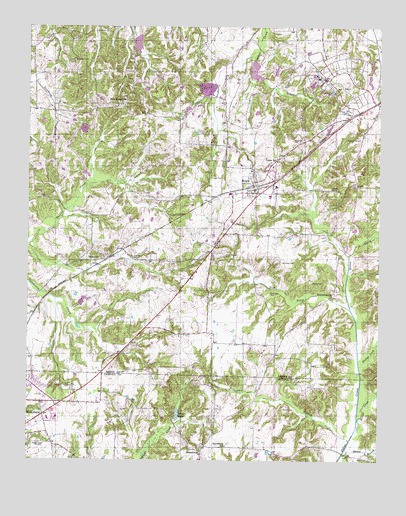
Henry, TN USGS Topographic Map
Click on map above to begin viewing in our Map Viewer.

This topographic map contains these locations and features:
Feature Name Type Latitude Longitude GNIS ID View Map
Allen CemeteryCemeteryN36.2064°W88.4342°1275590View Map
Allen CemeteryCemeteryN36.2217°W88.4664°1325971View Map
Atkin CemeteryCemeteryN36.2237°W88.4895°1325977View Map
Baker CemeteryCemeteryN36.1764°W88.3984°1276163View Map
Barton BranchStreamN36.1270°W88.3873°1276409View Map
Bethlehem CemeteryCemeteryN36.1723°W88.3914°1325983View Map
Bethlehem ChurchChurchN36.1726°W88.3914°1305173View Map
Bird-Miller CemeteryCemeteryN36.2256°W88.4698°1325984View Map
Blanchett CemeteryCemeteryN36.2173°W88.4056°1277658View Map
Bostick CemeteryCemeteryN36.2251°W88.4348°1325989View Map
Bowden CemeteryCemeteryN36.1962°W88.3920°1325991View Map
Bowers CemeteryCemeteryN36.2001°W88.4553°1325993View Map
Brewer CreekStreamN36.1367°W88.3823°1278298View Map
Brogdon CemeteryCemeteryN36.2401°W88.4834°1278452View Map
Caledonia School (historical)SchoolN36.1723°W88.4962°1317297View Map
Carroll County Rural Fire Department District 10 MacedoniaBuildingN36.1266°W88.4375°2654269View Map
Carter CemeteryCemeteryN36.1734°W88.4481°1326008View Map
Caton SchoolSchoolN36.2123°W88.4112°1279903View Map
Caton Springs CemeteryCemeteryN36.1845°W88.4298°1279904View Map
Clear LakeLakeN36.1375°W88.4464°1280676View Map
Cope CemeteryCemeteryN36.2351°W88.4248°1326018View Map
Covington-Wall CemeteryCemeteryN36.1764°W88.4953°1326020View Map
Dellahunty CemeteryCemeteryN36.2178°W88.3817°1306324View Map
Dinwiddie CemeteryCemeteryN36.1734°W88.4134°1282485View Map
Dinwiddie CemeteryCemeteryN36.1839°W88.4623°1282486View Map
Dinwiddie CemeteryCemeteryN36.1831°W88.4881°1326023View Map
H C Spinks Company LakeReservoirN36.2484°W88.4000°1302445View Map
H C Spinks Company Lake DamDamN36.2484°W88.4000°1302444View Map
Halls Chapel School (historical)SchoolN36.2448°W88.4300°1317325View Map
Hamlin CemeteryCemeteryN36.1401°W88.4087°1286669View Map
Harper CemeteryCemeteryN36.2034°W88.3920°1286914View Map
HenryPopulated PlaceN36.2039°W88.4198°1287430View Map
Henry Baptist ChurchChurchN36.2026°W88.4184°1644936View Map
Henry CemeteryCemeteryN36.1878°W88.4375°1326043View Map
Henry Division (historical)CensusN36.1928°W88.4303°1648779View Map
Henry Elementary SchoolSchoolN36.2039°W88.4120°1317328View Map
Henry Post OfficePost OfficeN36.2019°W88.4211°1650793View Map
Henry Volunteer Fire DepartmentBuildingN36.1980°W88.4178°2653620View Map
Irby CemeteryCemeteryN36.2239°W88.4787°1326048View Map
Liberty School (historical)SchoolN36.2442°W88.4984°1317342View Map
MacedoniaPopulated PlaceN36.1278°W88.4375°1292397View Map
Macedonia Community CenterBuildingN36.1278°W88.4375°1646039View Map
Macedonia SchoolSchoolN36.1292°W88.4292°1292429View Map
McKenzie Regional HospitalHospitalN36.1374°W88.4893°1320352View Map
Middle Fork Obion Dam Number SevenDamN36.2401°W88.4200°1302438View Map
Middle Fork Obion Lake Number SevenReservoirN36.2363°W88.4185°1302439View Map
Middle Fork Obion River Number Nine DamDamN36.2467°W88.4634°1302442View Map
Middle Fork Obion River Number Nine LakeReservoirN36.2451°W88.4613°1302443View Map
Mount Zion Church (historical)ChurchN36.2281°W88.4000°1317359View Map
Neal CemeteryCemeteryN36.1795°W88.3912°1326084View Map
Neil DitchStreamN36.1692°W88.3848°1295359View Map
New Bethel CemeteryCemeteryN36.2295°W88.4659°1326086View Map
New Bethel ChurchChurchN36.2287°W88.4653°1295437View Map
Old Salem CemeteryCemeteryN36.1837°W88.4739°1326097View Map
Perry CemeteryCemeteryN36.2406°W88.4617°1326109View Map
Perry School (historical)SchoolN36.1548°W88.4092°1317389View Map
Pettijohn BranchStreamN36.1312°W88.3850°1297263View Map
Rice School (historical)SchoolN36.1395°W88.4631°1320362View Map
Rushing CemeteryCemeteryN36.1826°W88.4095°1300279View Map
SalemPopulated PlaceN36.1823°W88.4762°1310796View Map
Salem ChurchChurchN36.1834°W88.4745°1300565View Map
Salem School (historical)SchoolN36.1828°W88.4737°1317409View Map
Slickup CreekStreamN36.1526°W88.3817°1304753View Map
Tennessee Department of Agriculture Division of Forestry RoutinBuildingN36.2251°W88.3759°2654226View Map
Town of HenryCivilN36.2004°W88.4109°2405819View Map
Wallace CemeteryCemeteryN36.2201°W88.4142°1326151View Map
WHDM-AM (McKenzie)TowerN36.1292°W88.4973°1639946View Map
Wiseman CemeteryCemeteryN36.2228°W88.3953°1326159View Map
Yarbrough Store (historical)LocaleN36.1556°W88.4117°1317439View Map

Note: Coordinates in the location and feature list above are referenced to NAD83 datum.


Copyright (C) 2008-2024 Ryan Niemi / Sunset Dynamics ... All Rights Reserved