TopoQuest Logo
Do you find TopoQuest useful?
Help keep TopoQuest running and adding new maps/features by donating!
Bitcoin:  19c7KJd3qBynnjoSw5npx9KScwjBe4ifkT
Litecoin:  LXs6TkuXGGXo1vDsWCkWVdjQX94eUKd6ui
Home View Maps Find Maps Find Places Resources & Links


Belews Creek, Missouri Topographic Map

USGS Map Title: Belews Creek, MO
USGS Map MRC: 38090C5
DRG (GeoTIFF) Download: o38090c5.tif


Neighboring USGS Topographic Map Quads:


  Pacific, MO  
38090D6
 

  House Springs, MO  
38090D5
 

  Maxville, MO  
38090D4
 

  Cedar Hill, MO  
38090C6
 

  Belews Creek, MO  
38090C5
 

  Herculaneum, MO  
38090C4
 

  Fletcher, MO  
38090B6
 

  De Soto, MO  
38090B5
 

  Festus, MO  
38090B4


Map MRC Location:

N39°
W91°
N39°
W90°
H8 H7 H6 H5 H4 H3 H2 H1
G8 G7 G6 G5 G4 G3 G2 G1
F8 F7 F6 F5 F4 F3 F2 F1
E8 E7 E6 E5 E4 E3 E2 E1
D8 D7 D6 D5 D4 D3 D2 D1
C8 C7 C6 C5 C4 C3 C2 C1
B8 B7 B6 B5 B4 B3 B2 B1
A8 A7 A6 A5 A4 A3 A2 A1
N38°
W91°
N38°
W90°

Belews Creek, MO USGS 1:24K Topographic Map Preview:
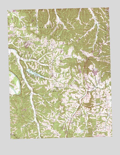
Belews Creek, MO USGS Topographic Map
Click on map above to begin viewing in our Map Viewer.

This topographic map contains these locations and features:
Feature Name Type Latitude Longitude GNIS ID View Map
Antonia Fire Protection District Station 3BuildingN38.3507°W90.5004°2621310View Map
Autumn LakeLakeN38.2630°W90.6058°2787814View Map
Baker School (historical)SchoolN38.3039°W90.5918°737699View Map
Becker LakeReservoirN38.2784°W90.6051°764234View Map
Becker Lake DamDamN38.2784°W90.6051°764233View Map
Belews CreekPopulated PlaceN38.2992°W90.5668°713888View Map
Bequette DamDamN38.3467°W90.5968°764270View Map
Boyher Lake DamDamN38.3417°W90.5585°765017View Map
Central School (historical)SchoolN38.2998°W90.5493°737702View Map
Cole LakeReservoirN38.3334°W90.5218°764224View Map
Cole Lake DamDamN38.3334°W90.5218°764223View Map
Daley Lake DamDamN38.2951°W90.5068°765188View Map
Deerwood Lake Number 3 DamDamN38.3417°W90.6018°764268View Map
Dehner Lake DamDamN38.3051°W90.5435°764212View Map
Galligher CreekStreamN38.2703°W90.5946°718318View Map
Glade ChapelChurchN38.2948°W90.5665°718480View Map
Glen Leonard DamDamN38.3351°W90.5368°764219View Map
Glen Leonard LakeReservoirN38.3351°W90.5368°764220View Map
GoldmanPopulated PlaceN38.2973°W90.5215°718546View Map
Goldman Fire Protection District Station 1 HeadquartersBuildingN38.2968°W90.5227°2467969View Map
Goldman Fire Protection District Station 2BuildingN38.3102°W90.5696°2620485View Map
Granada MeadowsPopulated PlaceN38.2997°W90.5328°2469179View Map
Gwenmil Lake DamDamN38.3401°W90.5985°765019View Map
Hideout LakeReservoirN38.2560°W90.5375°764214View Map
Hideout Lake DamDamN38.2567°W90.5368°764213View Map
Highland ChurchChurchN38.2648°W90.5479°719567View Map
Highland School (historical)SchoolN38.2653°W90.5482°737703View Map
Huskey School (historical)SchoolN38.2601°W90.5960°737700View Map
Jefferson CollegeSchoolN38.2595°W90.5593°720275View Map
Jefferson CountyCivilN38.2611°W90.5377°758504View Map
KNLC-TV (St Louis)TowerN38.3612°W90.5496°759313View Map
La Ferla Lake DamDamN38.3001°W90.5485°765187View Map
Lake Bo-No-DelReservoirN38.3103°W90.5721°764232View Map
Lake Bo-No-Del DamDamN38.3101°W90.5718°764231View Map
Lake LoraineReservoirN38.3124°W90.5192°764230View Map
Lake Lorraine DamDamN38.3101°W90.5201°764229View Map
Lake TamarackReservoirN38.3747°W90.6171°764258View Map
Lake TishomingoReservoirN38.3130°W90.5940°758353View Map
Lake Tishomingo DamDamN38.3167°W90.6035°763620View Map
Lakes of DeerwoodReservoirN38.3390°W90.6033°764226View Map
Lakes of Deerwood Number One DamDamN38.3401°W90.6051°764225View Map
Lakes of Deerwood Number Two DamDamN38.3417°W90.6051°764227View Map
Lindwell Lake DamDamN38.2867°W90.5068°765015View Map
LocalPopulated PlaceN38.3737°W90.6229°736320View Map
Mount Olive School (historical)SchoolN38.3403°W90.5437°737701View Map
Oak Hill School (historical)SchoolN38.3420°W90.5948°737698View Map
OttoPopulated PlaceN38.3709°W90.5004°723885View Map
ReginaPopulated PlaceN38.3264°W90.5921°741193View Map
Reichmuth Lake DamDamN38.3317°W90.5601°765018View Map
Sand RidgeRidgeN38.3292°W90.5312°726017View Map
Stephens ChurchChurchN38.2714°W90.5404°727069View Map
Sweetwater DamDamN38.3651°W90.5935°764235View Map
Sweetwater LakeReservoirN38.3645°W90.5942°764236View Map
Vatterott LakeReservoirN38.3141°W90.5377°764222View Map
Vatterott Lake DamDamN38.3134°W90.5368°764221View Map
Wagner Lake DamDamN38.3251°W90.5618°765016View Map

Note: Coordinates in the location and feature list above are referenced to NAD83 datum.


Copyright (C) 2008-2024 Ryan Niemi / Sunset Dynamics ... All Rights Reserved