TopoQuest Logo
Do you find TopoQuest useful?
Help keep TopoQuest running and adding new maps/features by donating!
Bitcoin:  19c7KJd3qBynnjoSw5npx9KScwjBe4ifkT
Litecoin:  LXs6TkuXGGXo1vDsWCkWVdjQX94eUKd6ui
Home View Maps Find Maps Find Places Resources & Links


De Soto, Missouri Topographic Map

USGS Map Title: De Soto, MO
USGS Map MRC: 38090B5
DRG (GeoTIFF) Download: o38090b5.tif


Neighboring USGS Topographic Map Quads:


  Cedar Hill, MO  
38090C6
 

  Belews Creek, MO  
38090C5
 

  Herculaneum, MO  
38090C4
 

  Fletcher, MO  
38090B6
 

  De Soto, MO  
38090B5
 

  Festus, MO  
38090B4
 

  Tiff, MO  
38090A6
 

  Vineland, MO  
38090A5
 

  Halifax, MO  
38090A4


Map MRC Location:

N39°
W91°
N39°
W90°
H8 H7 H6 H5 H4 H3 H2 H1
G8 G7 G6 G5 G4 G3 G2 G1
F8 F7 F6 F5 F4 F3 F2 F1
E8 E7 E6 E5 E4 E3 E2 E1
D8 D7 D6 D5 D4 D3 D2 D1
C8 C7 C6 C5 C4 C3 C2 C1
B8 B7 B6 B5 B4 B3 B2 B1
A8 A7 A6 A5 A4 A3 A2 A1
N38°
W91°
N38°
W90°

De Soto, MO USGS 1:24K Topographic Map Preview:
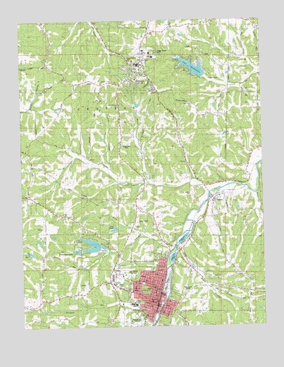
De Soto, MO USGS Topographic Map
Click on map above to begin viewing in our Map Viewer.

This topographic map contains these locations and features:
Feature Name Type Latitude Longitude GNIS ID View Map
Assembly of God ChurchChurchN38.2253°W90.5776°742838View Map
Ball BranchStreamN38.1606°W90.5446°713602View Map
Big Carp LakeReservoirN38.1551°W90.6201°738380View Map
Burrow Lake DamDamN38.2484°W90.5735°765014View Map
Calvary CemeteryCemeteryN38.1407°W90.5716°715212View Map
Church of the Good ShepardChurchN38.2334°W90.5665°737727View Map
City of De SotoCivilN38.1410°W90.5608°2394475View Map
City of De Soto Fire and Rescue Station 1 HeadquartersBuildingN38.1398°W90.5550°2467934View Map
City of De Soto Fire and Rescue Station 2BuildingN38.1523°W90.5606°2620751View Map
City of HillsboroCivilN38.2330°W90.5670°2394388View Map
Cotter CreekStreamN38.1784°W90.5285°716343View Map
De SotoPopulated PlaceN38.1395°W90.5551°716761View Map
De Soto High SchoolSchoolN38.1339°W90.5676°742842View Map
De Soto Police DepartmentBuildingN38.1399°W90.5543°2752584View Map
De Soto Post OfficePost OfficeN38.1425°W90.5628°2782825View Map
De Soto Rural Fire Protection District Station 1 HeadquartersBuildingN38.1338°W90.5542°2467673View Map
DeSoto Community Church of GodChurchN38.1389°W90.5578°2501058View Map
DeSoto Wastewater Treatment PlantLocaleN38.1594°W90.5433°2469013View Map
Fisher BranchStreamN38.1578°W90.5454°717950View Map
Fishermans LakeReservoirN38.1562°W90.5967°758396View Map
Fishermans Lake DamDamN38.1551°W90.5951°764871View Map
Fritz CreekStreamN38.1631°W90.5646°718257View Map
Good Shepherd CemeteryCemeteryN38.2345°W90.5690°718559View Map
Haverstick CreekStreamN38.1798°W90.5037°719216View Map
Haverstick School (historical)SchoolN38.1742°W90.5007°737724View Map
Hickory Hills Golf Club DamDamN38.1484°W90.5751°764180View Map
Hickory Hills Golf Club LakeReservoirN38.1493°W90.5756°764181View Map
Highfield School (historical)SchoolN38.1412°W90.5073°737725View Map
HillsboroPopulated PlaceN38.2323°W90.5629°736306View Map
Hillsboro CemeteryCemeteryN38.2274°W90.5583°2702343View Map
Hillsboro Fire Protection DistrictBuildingN38.2342°W90.5614°2620945View Map
Hillsboro Fire Protection District Station 2BuildingN38.2446°W90.6092°2621314View Map
Hillsboro Post OfficePost OfficeN38.2268°W90.5608°2782705View Map
Jefferson County Sheriff's OfficeBuildingN38.2310°W90.5649°2752220View Map
Joachim ParkParkN38.1339°W90.5535°742844View Map
KHAD-AM (Desoto)TowerN38.1395°W90.5423°759206View Map
KSTZ-FM (St Genevieve)TowerN38.2195°W90.5957°759155View Map
Lake BriarwoodReservoirN38.1566°W90.5903°758397View Map
Lake Briarwood DamDamN38.1584°W90.5851°764178View Map
Lake SiestaReservoirN38.1649°W90.5772°738381View Map
Lake WauwanokaReservoirN38.2307°W90.5354°728432View Map
Lake Wauwanoka DamDamN38.2267°W90.5301°763686View Map
Lone Pilgrim ChurchChurchN38.2159°W90.5362°742840View Map
Luckey ChurchChurchN38.1706°W90.6029°736321View Map
Lucky School (historical)SchoolN38.1728°W90.6037°737721View Map
Mount Saint Clements CollegeSchoolN38.1276°W90.5704°722884View Map
Murril BranchStreamN38.1839°W90.5598°723083View Map
New Liberty School (historical)SchoolN38.1759°W90.5693°737723View Map
Oak Ridge ChurchChurchN38.1989°W90.5737°723638View Map
Peace Tabernacle ChurchChurchN38.2159°W90.5740°742839View Map
Pentecostal ChurchChurchN38.1442°W90.5243°742845View Map
Peter Moore School (historical)SchoolN38.1353°W90.6115°737722View Map
Redeemer ChurchChurchN38.1456°W90.5735°742841View Map
Ritcher ParkParkN38.1381°W90.5507°725330View Map
Saint Louis Urban RegionAreaN38.2498°W90.5004°758112View Map
Seemel School (historical)SchoolN38.2151°W90.6035°737720View Map
Shepley HollowValleyN38.1901°W90.5798°726330View Map
Siesta Lake DamDamN38.1651°W90.5768°765013View Map
Spring LakeReservoirN38.1576°W90.5832°758369View Map
Spring Lake DamDamN38.1567°W90.5818°764179View Map
Spross ParkParkN38.1348°W90.5637°726966View Map
Tanyard BranchStreamN38.1303°W90.5557°727452View Map
Township of CentralCivilN38.2410°W90.5696°766823View Map
VictoriaPopulated PlaceN38.1778°W90.5260°736359View Map
Victoria CemeteryCemeteryN38.1789°W90.5377°728186View Map
Vineland SchoolSchoolN38.1273°W90.5696°742843View Map
Woodlawn Memorial ParkCemeteryN38.1264°W90.5657°729113View Map

Note: Coordinates in the location and feature list above are referenced to NAD83 datum.


Copyright (C) 2008-2024 Ryan Niemi / Sunset Dynamics ... All Rights Reserved