TopoQuest Logo
Do you find TopoQuest useful?
Help keep TopoQuest running and adding new maps/features by donating!
Bitcoin:  19c7KJd3qBynnjoSw5npx9KScwjBe4ifkT
Litecoin:  LXs6TkuXGGXo1vDsWCkWVdjQX94eUKd6ui
Home View Maps Find Maps Find Places Resources & Links


Belgique, Missouri Topographic Map

USGS Map Title: Belgique, MO
USGS Map MRC: 37089G7
DRG (GeoTIFF) Download: o37089g7.tif


Neighboring USGS Topographic Map Quads:


  Kaskaskia, IL  
37089H8
 

  Chester, IL  
37089H7
 

  Welge, IL  
37089H6
 

  Lithium, MO  
37089G8
 

  Belgique, MO  
37089G7
 

  Rockwood, IL  
37089G6
 

  Perryville West, MO  
37089F8
 

  Perryville East, MO  
37089F7
 

  Crosstown, MO  
37089F6


Map MRC Location:

N38°
W90°
N38°
W89°
H8 H7 H6 H5 H4 H3 H2 H1
G8 G7 G6 G5 G4 G3 G2 G1
F8 F7 F6 F5 F4 F3 F2 F1
E8 E7 E6 E5 E4 E3 E2 E1
D8 D7 D6 D5 D4 D3 D2 D1
C8 C7 C6 C5 C4 C3 C2 C1
B8 B7 B6 B5 B4 B3 B2 B1
A8 A7 A6 A5 A4 A3 A2 A1
N37°
W90°
N37°
W89°

Belgique, MO USGS 1:24K Topographic Map Preview:
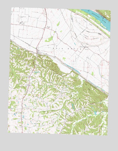
Belgique, MO USGS Topographic Map
Click on map above to begin viewing in our Map Viewer.

This topographic map contains these locations and features:
Feature Name Type Latitude Longitude GNIS ID View Map
BelgiquePopulated PlaceN37.8376°W89.7812°713893View Map
Big HollowValleyN37.8037°W89.7823°714173View Map
Boxdorfer SchoolSchoolN37.7703°W89.8001°714592View Map
Brown BranchStreamN37.7931°W89.7884°714758View Map
Christisen BranchStreamN37.7953°W89.7943°715810View Map
Crains IslandIslandN37.8617°W89.7779°406730View Map
Dry ForkStreamN37.7731°W89.7520°717112View Map
Hoff SchoolSchoolN37.8156°W89.8268°748175View Map
Huber BranchStreamN37.7756°W89.8090°719944View Map
Lady of Victory ChurchChurchN37.7978°W89.8521°736416View Map
McBridePopulated PlaceN37.8328°W89.8401°722028View Map
McClanahan CreekStreamN37.8028°W89.7762°736323View Map
McClannahan MillLocaleN37.7962°W89.7959°736415View Map
Miles School (historical)SchoolN37.7573°W89.8393°748177View Map
Morey SchoolSchoolN37.8612°W89.8587°748174View Map
Nativity CemeteryCemeteryN37.8359°W89.7768°723129View Map
Perryville Regional AirportAirportN37.8610°W89.8614°758858View Map
Preston CemeteryCemeteryN37.8025°W89.8332°724916View Map
Puckett IslandIslandN37.8464°W89.7746°724985View Map
School Number 73SchoolN37.8067°W89.8504°755398View Map
SerenoPopulated PlaceN37.7978°W89.8512°726210View Map
Sereno School (historical)SchoolN37.7870°W89.8559°748176View Map
Streiler BranchStreamN37.7920°W89.7971°727178View Map
Township of Bois BruleCivilN37.8215°W89.7922°767151View Map
Turkey Toe Canyon Lake DamDamN37.7767°W89.7701°764663View Map
Twin LakesReservoirN37.7791°W89.7944°764660View Map
Twin Lakes Lower DamDamN37.7801°W89.7951°764659View Map

Note: Coordinates in the location and feature list above are referenced to NAD83 datum.


Copyright (C) 2008-2024 Ryan Niemi / Sunset Dynamics ... All Rights Reserved