TopoQuest Logo
Do you find TopoQuest useful?
Help keep TopoQuest running and adding new maps/features by donating!
Bitcoin:  19c7KJd3qBynnjoSw5npx9KScwjBe4ifkT
Litecoin:  LXs6TkuXGGXo1vDsWCkWVdjQX94eUKd6ui
Home View Maps Find Maps Find Places Resources & Links


Perryville West, Missouri Topographic Map

USGS Map Title: Perryville West, MO
USGS Map MRC: 37089F8
DRG (GeoTIFF) Download: o37089f8.tif


Neighboring USGS Topographic Map Quads:


  Minnith, MO  
37090G1
 

  Lithium, MO  
37089G8
 

  Belgique, MO  
37089G7
 

  Parker Lake, MO  
37090F1
 

  Perryville West, MO  
37089F8
 

  Perryville East, MO  
37089F7
 

  Patton, MO  
37090E1
 

  Sedgewickville, MO  
37089E8
 

  Friedheim, MO  
37089E7


Map MRC Location:

N38°
W90°
N38°
W89°
H8 H7 H6 H5 H4 H3 H2 H1
G8 G7 G6 G5 G4 G3 G2 G1
F8 F7 F6 F5 F4 F3 F2 F1
E8 E7 E6 E5 E4 E3 E2 E1
D8 D7 D6 D5 D4 D3 D2 D1
C8 C7 C6 C5 C4 C3 C2 C1
B8 B7 B6 B5 B4 B3 B2 B1
A8 A7 A6 A5 A4 A3 A2 A1
N37°
W90°
N37°
W89°

Perryville West, MO USGS 1:24K Topographic Map Preview:
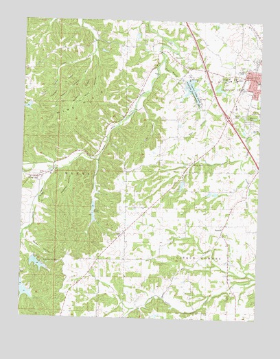
Perryville West, MO USGS Topographic Map
Click on map above to begin viewing in our Map Viewer.

This topographic map contains these locations and features:
Feature Name Type Latitude Longitude GNIS ID View Map
Barbier RidgeRidgeN37.7201°W89.9684°738561View Map
City of PerryvilleCivilN37.7256°W89.8760°2396186View Map
Cody HollowValleyN37.7201°W89.9351°738564View Map
Colonial Acres LakeReservoirN37.6811°W89.9156°763774View Map
Colonial Acres Lake DamDamN37.6834°W89.9151°763773View Map
County Lake State Wildlife Management AreaParkN37.7214°W89.9098°743266View Map
Eddleman Lake DamDamN37.7451°W89.9401°765162View Map
Friendly ValleyPopulated PlaceN37.6901°W89.9107°738565View Map
Happy HollowValleyN37.6937°W89.9593°738557View Map
Hickory Hollow Lake DamDamN37.7151°W89.9968°764903View Map
HighlandPopulated PlaceN37.6645°W89.8915°719560View Map
Highland School (historical)SchoolN37.6648°W89.8998°736423View Map
Hunt BranchStreamN37.7339°W89.9265°738566View Map
Hunt SchoolSchoolN37.7051°W89.9084°720006View Map
Kuhlman HollowValleyN37.6887°W89.9759°738558View Map
Lake Kah-Tan-DaReservoirN37.6474°W89.9915°738554View Map
Lake Kah-Tan-Da DamDamN37.6498°W89.9940°764682View Map
Legion LakeReservoirN37.7098°W89.8778°764662View Map
Legion Lake DamDamN37.7101°W89.8768°764661View Map
Mach Lake DamDamN37.7384°W89.9584°763771View Map
Marys Lake DamDamN37.7217°W89.8984°763769View Map
Mine HillsRangeN37.7139°W89.9718°738559View Map
Mine HollowValleyN37.7362°W89.9632°738560View Map
Missouri Department of Conservation Forestry Southeast Regional Field Fire Office PerryvilleBuildingN37.7289°W89.8974°2621166View Map
Mount Hope CemeteryCemeteryN37.7262°W89.8937°743268View Map
Nations CreekStreamN37.6876°W89.9798°751262View Map
Number 19 ReservoirReservoirN37.7370°W89.9580°763772View Map
Ollie Moore Lower Lake DamDamN37.6784°W89.8968°764904View Map
Papaw HollowValleyN37.6589°W89.9990°738555View Map
Park SpringSpringN37.7103°W89.8804°738567View Map
Pecaut HollowValleyN37.7356°W89.9643°738562View Map
Pecaut RidgeRidgeN37.7220°W89.9798°738498View Map
Perco Lake North DamDamN37.6734°W89.9618°764681View Map
Perco Lake South DamDamN37.6684°W89.9618°765012View Map
Perco LakesReservoirN37.6717°W89.9622°738556View Map
Perry County Community LakeReservoirN37.7215°W89.9113°764665View Map
Perry County Community Lake DamDamN37.7251°W89.9151°764664View Map
Perryville Country ClubLocaleN37.7123°W89.8793°743267View Map
Rock Valley SchoolSchoolN37.7431°W89.9079°725474View Map
Saint Joseph ChurchChurchN37.6603°W89.8943°743257View Map
Saint Marys of the Barrens CemeteryCemeteryN37.7254°W89.8898°2702636View Map
Saint Marys SeminarySchoolN37.7267°W89.8873°736344View Map
Saint Rosas ChurchChurchN37.6839°W89.9921°736422View Map
Saint Rose of Lima CemeteryCemeteryN37.6845°W89.9909°743258View Map
Saint Vincent SchoolSchoolN37.7251°W89.8759°743256View Map
Sandy BranchStreamN37.6917°W89.8840°719570View Map
Seminary LakeReservoirN37.7218°W89.8965°763770View Map
Silver LakePopulated PlaceN37.6837°W89.9901°726452View Map
Silver LakeLakeN37.6861°W89.9852°736421View Map
Sim Layton SchoolSchoolN37.7420°W89.9534°726461View Map
Tyler BranchStreamN37.6920°W89.8829°727943View Map
Vacant HollowValleyN37.7289°W89.9829°738563View Map
Wilhelm School (historical)SchoolN37.6612°W89.9490°728854View Map

Note: Coordinates in the location and feature list above are referenced to NAD83 datum.


Copyright (C) 2008-2024 Ryan Niemi / Sunset Dynamics ... All Rights Reserved