TopoQuest Logo
Do you find TopoQuest useful?
Help keep TopoQuest running and adding new maps/features by donating!
Bitcoin:  19c7KJd3qBynnjoSw5npx9KScwjBe4ifkT
Litecoin:  LXs6TkuXGGXo1vDsWCkWVdjQX94eUKd6ui
Home View Maps Find Maps Find Places Resources & Links


Lithium, Missouri Topographic Map

USGS Map Title: Lithium, MO
USGS Map MRC: 37089G8
DRG (GeoTIFF) Download: o37089g8.tif


Neighboring USGS Topographic Map Quads:


  Sainte Genevieve, MO  
37090H1
 

  Kaskaskia, IL  
37089H8
 

  Chester, IL  
37089H7
 

  Minnith, MO  
37090G1
 

  Lithium, MO  
37089G8
 

  Belgique, MO  
37089G7
 

  Parker Lake, MO  
37090F1
 

  Perryville West, MO  
37089F8
 

  Perryville East, MO  
37089F7


Map MRC Location:

N38°
W90°
N38°
W89°
H8 H7 H6 H5 H4 H3 H2 H1
G8 G7 G6 G5 G4 G3 G2 G1
F8 F7 F6 F5 F4 F3 F2 F1
E8 E7 E6 E5 E4 E3 E2 E1
D8 D7 D6 D5 D4 D3 D2 D1
C8 C7 C6 C5 C4 C3 C2 C1
B8 B7 B6 B5 B4 B3 B2 B1
A8 A7 A6 A5 A4 A3 A2 A1
N37°
W90°
N37°
W89°

Lithium, MO USGS 1:24K Topographic Map Preview:
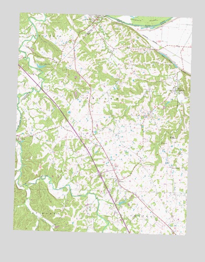
Lithium, MO USGS Topographic Map
Click on map above to begin viewing in our Map Viewer.

This topographic map contains these locations and features:
Feature Name Type Latitude Longitude GNIS ID View Map
Ball Mill ResurgenceSpringN37.8056°W89.8894°713603View Map
Blue SpringSpringN37.8028°W89.8951°714429View Map
Blue Spring BranchStreamN37.8445°W89.8815°714431View Map
Bois Brule SchoolSchoolN37.8695°W89.8862°748168View Map
BrewerPopulated PlaceN37.7809°W89.9254°714672View Map
Brewer Census Designated PlaceCensusN37.7836°W89.9180°2587056View Map
Brown CemeteryCemeteryN37.8498°W89.9609°714763View Map
Cedar ForkStreamN37.7801°W89.9973°749292View Map
Cedar Valley LakeLakeN37.8434°W89.9851°758262View Map
Cedar Valley Lake DamDamN37.8434°W89.9851°763738View Map
Circle K DamDamN37.7517°W89.9701°765036View Map
Circle K Ranch LakeReservoirN37.7517°W89.9701°765037View Map
Cissell SchoolSchoolN37.8070°W89.9404°748166View Map
City of Saint MaryCivilN37.8737°W89.9497°2396504View Map
Colfelt BranchStreamN37.7848°W89.9968°738175View Map
Ellis Lake DamDamN37.8234°W89.8934°764902View Map
Falls BranchStreamN37.8356°W89.8840°717835View Map
GiboneyPopulated PlaceN37.8048°W89.9907°740869View Map
Goose CreekStreamN37.7759°W89.9904°750079View Map
Guethle SchoolSchoolN37.8420°W89.9693°748165View Map
Guittar HollowValleyN37.7848°W89.9968°738176View Map
Knob School (historical)SchoolN37.8178°W89.9057°748171View Map
Lach Difani DamDamN37.8301°W89.9601°764865View Map
Lakenan Lake DamDamN37.8267°W89.8901°764901View Map
LithiumPopulated PlaceN37.8334°W89.8859°721146View Map
Lithium Census Designated PlaceCensusN37.8320°W89.8824°2787908View Map
Lithium SpringSpringN37.8339°W89.8843°736414View Map
Little Saline CreekStreamN37.8687°W89.9907°750797View Map
Mattingly SchoolSchoolN37.7959°W89.9737°748167View Map
Moranville SchoolSchoolN37.7578°W89.8946°748173View Map
Perryville Junction (historical)LocaleN37.8642°W89.9115°748169View Map
Rock Valley LakeReservoirN37.7676°W89.9222°763560View Map
Rock Valley Lake DamDamN37.7667°W89.9251°763559View Map
Saint Laurent CreekStreamN37.8748°W89.9373°736341View Map
Saint Mary Volunteer Fire DepartmentBuildingN37.8657°W89.9512°2621188View Map
Saline JunctionPopulated PlaceN37.7889°W89.8868°741231View Map
Thompson SchoolSchoolN37.8448°W89.9262°748170View Map
Township of SalineCivilN37.8173°W89.9350°767157View Map
Tucker School (historical)SchoolN37.7937°W89.8834°748172View Map
Village of LithiumCivilN37.8328°W89.8847°2398452View Map

Note: Coordinates in the location and feature list above are referenced to NAD83 datum.


Copyright (C) 2008-2024 Ryan Niemi / Sunset Dynamics ... All Rights Reserved