TopoQuest Logo
Do you find TopoQuest useful?
Help keep TopoQuest running and adding new maps/features by donating!
Bitcoin:  19c7KJd3qBynnjoSw5npx9KScwjBe4ifkT
Litecoin:  LXs6TkuXGGXo1vDsWCkWVdjQX94eUKd6ui
Home View Maps Find Maps Find Places Resources & Links


Nashua, Missouri Topographic Map

USGS Map Title: Nashua, MO
USGS Map MRC: 39094C5
DRG (GeoTIFF) Download: o39094c5.tif


Neighboring USGS Topographic Map Quads:


  Camden Point, MO  
39094D6
 

  Smithville, MO  
39094D5
 

  Arley, MO  
39094D4
 

  Ferrelview, MO  
39094C6
 

  Nashua, MO  
39094C5
 

  Kearney SW, MO  
39094C4
 

  Parkville, MO  
39094B6
 

  North Kansas City, MO  
39094B5
 

  Liberty, MO  
39094B4


Map MRC Location:

N40°
W95°
N40°
W94°
H8 H7 H6 H5 H4 H3 H2 H1
G8 G7 G6 G5 G4 G3 G2 G1
F8 F7 F6 F5 F4 F3 F2 F1
E8 E7 E6 E5 E4 E3 E2 E1
D8 D7 D6 D5 D4 D3 D2 D1
C8 C7 C6 C5 C4 C3 C2 C1
B8 B7 B6 B5 B4 B3 B2 B1
A8 A7 A6 A5 A4 A3 A2 A1
N39°
W95°
N39°
W94°

Nashua, MO USGS 1:24K Topographic Map Preview:
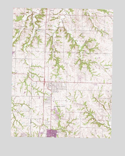
Nashua, MO USGS Topographic Map
Click on map above to begin viewing in our Map Viewer.

This topographic map contains these locations and features:
Feature Name Type Latitude Longitude GNIS ID View Map
AmoryLocaleN39.3422°W94.5741°746581View Map
Barry SchoolSchoolN39.2526°W94.6055°2545254View Map
Bell LakeReservoirN39.3550°W94.5952°758249View Map
Bell Lake DamDamN39.3550°W94.5952°761178View Map
Bell Prairie Elementary SchoolSchoolN39.2908°W94.5410°2545116View Map
Bell School (historical)SchoolN39.2869°W94.5150°742376View Map
Church of ChristChurchN39.3011°W94.5805°2477118View Map
Dunham Private AirportAirportN39.3309°W94.5566°758942View Map
First CreekStreamN39.3725°W94.5919°717931View Map
Fox Hill Elementary SchoolSchoolN39.2850°W94.5690°2477832View Map
Gordon SchoolSchoolN39.3317°W94.5219°718618View Map
Greater Monumental Baptist Church of Jesus ChristChurchN39.2555°W94.5655°2477141View Map
Holy Family Parish ChurchChurchN39.2669°W94.5680°2477168View Map
Kansas City Missouri Fire Department Station 3BuildingN39.2951°W94.5748°2620481View Map
KCMO-AM (Kansas City)TowerN39.3056°W94.5752°754259View Map
KGGN-AM (Gladstone)TowerN39.3342°W94.5672°759182View Map
King of Kings Lutheran ChurchChurchN39.2675°W94.5577°2477194View Map
Lone Star SchoolSchoolN39.2983°W94.5758°742375View Map
Martin School (historical)SchoolN39.3547°W94.5997°746580View Map
Mitchell SchoolSchoolN39.3708°W94.5150°742373View Map
Mount Olive ChurchChurchN39.3317°W94.5277°722820View Map
NashuaPopulated PlaceN39.3006°W94.5800°723123View Map
Nashua Baptist ChurchChurchN39.3008°W94.5802°2477244View Map
Nashua Elementary SchoolSchoolN39.3000°W94.5775°2477887View Map
National American University Zona Rosa CampusSchoolN39.2526°W94.5961°2545477View Map
New Life Community ChurchChurchN39.2740°W94.5836°2477254View Map
New Mark Middle SchoolSchoolN39.2848°W94.5718°2477888View Map
Northview Elementary SchoolSchoolN39.2612°W94.5369°2477890View Map
Number 178 DamDamN39.3350°W94.5352°761177View Map
Pathfinder Elementary SchoolSchoolN39.2510°W94.6033°2545201View Map
Polecat CreekStreamN39.3381°W94.5394°724704View Map
Resurrection CemeteryCemeteryN39.3021°W94.5215°725230View Map
Rocky BranchStreamN39.3617°W94.5630°725502View Map
Rollert Farm AirportAirportN39.3517°W94.5173°2679389View Map
Sampson LakeReservoirN39.3011°W94.6244°762541View Map
Smithville Area Fire Protection DistrictBuildingN39.3639°W94.5849°2620360View Map
Smithville Middle SchoolSchoolN39.3729°W94.5740°2545440View Map
Smithville Post OfficePost OfficeN39.3739°W94.5844°2782951View Map
Smithville Upper Elementary SchoolSchoolN39.3712°W94.5733°2545465View Map
Staley High SchoolSchoolN39.2884°W94.5437°2545122View Map
Stevens LakeReservoirN39.2930°W94.6089°762543View Map
Stevens Lake DamDamN39.2933°W94.6086°762542View Map
Woods SchoolLocaleN39.3328°W94.5780°742374View Map

Note: Coordinates in the location and feature list above are referenced to NAD83 datum.


Copyright (C) 2008-2024 Ryan Niemi / Sunset Dynamics ... All Rights Reserved