TopoQuest Logo
Do you find TopoQuest useful?
Help keep TopoQuest running and adding new maps/features by donating!
Bitcoin:  19c7KJd3qBynnjoSw5npx9KScwjBe4ifkT
Litecoin:  LXs6TkuXGGXo1vDsWCkWVdjQX94eUKd6ui
Home View Maps Find Maps Find Places Resources & Links


Bellwood, Tennessee Topographic Map

USGS Map Title: Bellwood, TN
USGS Map MRC: 36086C2
DRG (GeoTIFF) Download: o36086c2.tif


Neighboring USGS Topographic Map Quads:


  Bethpage, TN  
36086D3
 

  Hartsville, TN  
36086D2
 

  Hillsdale, TN  
36086D1
 

  Hunters Point, TN  
36086C3
 

  Bellwood, TN  
36086C2
 

  Dixon Springs, TN  
36086C1
 

  Lebanon, TN  
36086B3
 

  Shop Springs, TN  
36086B2
 

  New Middleton, TN  
36086B1


Map MRC Location:

N37°
W87°
N37°
W86°
H8 H7 H6 H5 H4 H3 H2 H1
G8 G7 G6 G5 G4 G3 G2 G1
F8 F7 F6 F5 F4 F3 F2 F1
E8 E7 E6 E5 E4 E3 E2 E1
D8 D7 D6 D5 D4 D3 D2 D1
C8 C7 C6 C5 C4 C3 C2 C1
B8 B7 B6 B5 B4 B3 B2 B1
A8 A7 A6 A5 A4 A3 A2 A1
N36°
W87°
N36°
W86°

Bellwood, TN USGS 1:24K Topographic Map Preview:
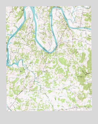
Bellwood, TN USGS Topographic Map
Click on map above to begin viewing in our Map Viewer.

This topographic map contains these locations and features:
Feature Name Type Latitude Longitude GNIS ID View Map
Athens Missionary ChurchChurchN36.2973°W86.1955°1304890View Map
Bass CemeteryCemeteryN36.3459°W86.2147°1276436View Map
Beasleys BendBendN36.3570°W86.2169°1276688View Map
Belchers BluffCliffN36.3253°W86.1769°1276893View Map
Bellview ChurchChurchN36.3276°W86.2167°1323144View Map
Bellview School (historical)SchoolN36.3267°W86.2153°1323145View Map
BellwoodPopulated PlaceN36.2534°W86.1472°1276973View Map
Bellwood SchoolSchoolN36.2528°W86.1303°1276974View Map
Berdine BarBarN36.3450°W86.2347°1643683View Map
Bethel ChurchChurchN36.3298°W86.2228°1323148View Map
Carman CemeteryCemeteryN36.3553°W86.1489°1279682View Map
Cedar CreekStreamN36.3056°W86.2480°1305756View Map
Cedar Creek ChurchChurchN36.3073°W86.2147°1305758View Map
Cedar Creek IslandIslandN36.3089°W86.2494°1643681View Map
CentervillePopulated PlaceN36.2895°W86.2067°1305812View Map
Clendenon BranchStreamN36.2803°W86.2003°1280704View Map
Clifford BranchStreamN36.2903°W86.2078°1647668View Map
Coleman-Winston Memorial BridgeBridgeN36.3734°W86.1750°1280957View Map
Commissioner District 1CivilN36.3727°W86.1515°2464290View Map
Commissioner District 10CivilN36.3451°W86.1678°2464328View Map
Commissioner District 6CivilN36.2958°W86.2452°2464587View Map
Conway SchoolSchoolN36.2914°W86.2217°1281104View Map
Dickerson ChapelChurchN36.2984°W86.2305°1282436View Map
Dickson BluffCliffN36.3239°W86.2489°1282453View Map
Dickson Chapel Recreation AreaParkN36.3062°W86.2325°1323166View Map
Dixon (historical)Populated PlaceN36.2984°W86.2300°1312830View Map
Douglas BranchStreamN36.3478°W86.1458°1643688View Map
Everetts BranchStreamN36.3426°W86.2075°1283922View Map
Foley BranchStreamN36.3464°W86.1386°1284550View Map
Goose CreekStreamN36.3587°W86.1603°1285673View Map
Goose Creek BarBarN36.3595°W86.1628°1643693View Map
Goose Creek Island (historical)IslandN36.3598°W86.1622°1643692View Map
Goshen CemeteryCemeteryN36.2764°W86.1678°1285715View Map
Goshen ChurchChurchN36.2764°W86.1678°1285718View Map
Gray HollowValleyN36.3252°W86.1360°1286007View Map
Griffins LandingLocaleN36.3309°W86.1755°1643687View Map
Harts Ferry (historical)LocaleN36.3712°W86.1680°1643694View Map
Hartsville Access AreaParkN36.3725°W86.1680°1643696View Map
Hartsville IslandIslandN36.3623°W86.1855°1287065View Map
Hartsville LandingLocaleN36.3731°W86.1692°1643695View Map
Hopewell ChurchChurchN36.2539°W86.1344°1288316View Map
Jackson BranchStreamN36.3389°W86.2403°1289185View Map
Jackson CemeteryCemeteryN36.3295°W86.2192°1289207View Map
Johnson BranchStreamN36.2667°W86.1892°1289532View Map
King SchoolSchoolN36.3495°W86.2133°1290235View Map
Link BranchStreamN36.2578°W86.2489°1291340View Map
Little Goose CreekStreamN36.3684°W86.1511°1291514View Map
Lyles CreekStreamN36.3478°W86.1458°1292329View Map
Mills IslandIslandN36.3528°W86.2089°1643685View Map
Mills Island BarBarN36.3542°W86.2064°1643686View Map
Mitchells BluffCliffN36.3198°W86.1886°1294120View Map
Nancy BranchStreamN36.3001°W86.2228°1295222View Map
Neely BranchStreamN36.3667°W86.2078°1269827View Map
Old Lock and Dam Number Five (historical)DamN36.3181°W86.2472°1643682View Map
Old Lock and Dam Number Six (historical)DamN36.3487°W86.1425°1643689View Map
ProvidencePopulated PlaceN36.3356°W86.1528°1309986View Map
Providence Presbyterian ChurchChurchN36.3351°W86.1530°1646078View Map
Providence School (historical)SchoolN36.3351°W86.1522°1323616View Map
Purnell BranchStreamN36.2678°W86.1828°1298708View Map
Puryears BendBendN36.3384°W86.1911°1298714View Map
Reeds Mill (historical)LocaleN36.2881°W86.2078°1323236View Map
Riadon BranchStreamN36.3287°W86.1750°1299286View Map
Sampson ShoalsBarN36.3389°W86.2411°1310163View Map
Second Creek IslandIslandN36.3734°W86.2114°1301022View Map
Shady GrovePopulated PlaceN36.3684°W86.1375°1301157View Map
Shady Grove Access AreaParkN36.3739°W86.1355°1643691View Map
Spanish Needle KnobSummitN36.2903°W86.1386°1270946View Map
Speck CemeteryCemeteryN36.2773°W86.2219°1270970View Map
Stone BranchStreamN36.3351°W86.1355°1271472View Map
TaylorsvillePopulated PlaceN36.2756°W86.1997°1272255View Map
Tomlinson CemeteryCemeteryN36.2948°W86.2092°1272756View Map
Trousdale County ParkParkN36.3509°W86.1430°1323617View Map
Walnut Ridge Church (historical)ChurchN36.3051°W86.1725°1323269View Map
Ward BranchStreamN36.3351°W86.1355°1273777View Map
Ward HillSummitN36.3198°W86.1480°1273789View Map
Weir (historical)Populated PlaceN36.2714°W86.1953°1312891View Map
Weir CemeteryCemeteryN36.2712°W86.1936°1323275View Map
White CemeteryCemeteryN36.2734°W86.2219°1274351View Map
Whites BluffCliffN36.3528°W86.1597°1274451View Map
Whitleys BluffCliffN36.3698°W86.2242°1304565View Map
Whitleys IslandIslandN36.3667°W86.2225°1643684View Map
Wier CemeteryCemeteryN36.2512°W86.1944°1274514View Map
Young BranchStreamN36.2520°W86.1817°1275316View Map
Zion ChurchChurchN36.3575°W86.1905°1304728View Map

Note: Coordinates in the location and feature list above are referenced to NAD83 datum.


Copyright (C) 2008-2024 Ryan Niemi / Sunset Dynamics ... All Rights Reserved