TopoQuest Logo
Do you find TopoQuest useful?
Help keep TopoQuest running and adding new maps/features by donating!
Bitcoin:  19c7KJd3qBynnjoSw5npx9KScwjBe4ifkT
Litecoin:  LXs6TkuXGGXo1vDsWCkWVdjQX94eUKd6ui
Home View Maps Find Maps Find Places Resources & Links


Shop Springs, Tennessee Topographic Map

USGS Map Title: Shop Springs, TN
USGS Map MRC: 36086B2
DRG (GeoTIFF) Download: o36086b2.tif


Neighboring USGS Topographic Map Quads:


  Hunters Point, TN  
36086C3
 

  Bellwood, TN  
36086C2
 

  Dixon Springs, TN  
36086C1
 

  Lebanon, TN  
36086B3
 

  Shop Springs, TN  
36086B2
 

  New Middleton, TN  
36086B1
 

  Vine, TN  
36086A3
 

  Watertown, TN  
36086A2
 

  Alexandria, TN  
36086A1


Map MRC Location:

N37°
W87°
N37°
W86°
H8 H7 H6 H5 H4 H3 H2 H1
G8 G7 G6 G5 G4 G3 G2 G1
F8 F7 F6 F5 F4 F3 F2 F1
E8 E7 E6 E5 E4 E3 E2 E1
D8 D7 D6 D5 D4 D3 D2 D1
C8 C7 C6 C5 C4 C3 C2 C1
B8 B7 B6 B5 B4 B3 B2 B1
A8 A7 A6 A5 A4 A3 A2 A1
N36°
W87°
N36°
W86°

Shop Springs, TN USGS 1:24K Topographic Map Preview:
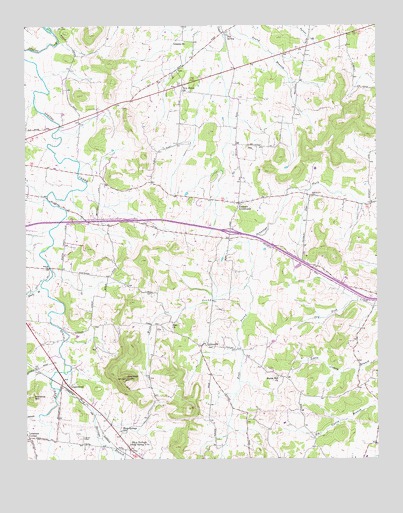
Shop Springs, TN USGS Topographic Map
Click on map above to begin viewing in our Map Viewer.

This topographic map contains these locations and features:
Feature Name Type Latitude Longitude GNIS ID View Map
Bethany ChurchChurchN36.1931°W86.2230°1305115View Map
Bethlehem CemeteryCemeteryN36.2006°W86.1483°1277159View Map
Big SpringSpringN36.2476°W86.1776°1277406View Map
Big Spring (historical)Populated PlaceN36.2489°W86.1772°1312812View Map
Black BranchStreamN36.1745°W86.2439°1269351View Map
Byran CemeteryCemeteryN36.1314°W86.2294°1279244View Map
Commissioner District 15CivilN36.2290°W86.1718°2464391View Map
Commissioner District 7CivilN36.1591°W86.2232°2464655View Map
Dedman BranchStreamN36.1381°W86.2453°1282281View Map
East Prong Jennings ForkStreamN36.1751°W86.1711°1283395View Map
GreenwoodPopulated PlaceN36.1464°W86.2347°1286189View Map
Grissim BranchStreamN36.2426°W86.1808°1647669View Map
Grissim ChurchChurchN36.2453°W86.1925°1286323View Map
Interchange 245CrossingN36.1903°W86.1772°1312855View Map
Jennings KnobSummitN36.1481°W86.2142°1289384View Map
Leemans CornerPopulated PlaceN36.1320°W86.2492°1315373View Map
LinwoodPopulated PlaceN36.1578°W86.1853°1315409View Map
Linwood Baptist ChurchChurchN36.1589°W86.1900°1323206View Map
Linwood School (historical)SchoolN36.1598°W86.1914°1323207View Map
Locust Grove School (historical)SchoolN36.1648°W86.2272°1323208View Map
New Shiloh ChurchChurchN36.2326°W86.1930°1295649View Map
Poplar Hill ChurchChurchN36.1489°W86.1603°1298204View Map
Poplar Hill School (historical)SchoolN36.1487°W86.1600°1323233View Map
Saulsbury School (historical)SchoolN36.1673°W86.1275°1323245View Map
Shop SpringsPopulated PlaceN36.1278°W86.2122°1303602View Map
Shop Springs Baptist ChurchChurchN36.1326°W86.2186°1323250View Map
Shop Springs BranchStreamN36.1506°W86.2342°1270170View Map
Shop Springs SchoolSchoolN36.1334°W86.2164°1270171View Map
Spring Creek (historical)Populated PlaceN36.1489°W86.2425°1312885View Map
Sugar Flat School (historical)SchoolN36.2334°W86.1936°1323261View Map
Tuckers CrossroadsPopulated PlaceN36.1989°W86.1739°1304185View Map
Tuckers Crossroads Elementary SchoolSchoolN36.1992°W86.1758°1323265View Map
West Prong Jennings ForkStreamN36.1751°W86.1717°1274221View Map
Wilson Emergency Management Agency Station 8 Tuckers CrossroadsBuildingN36.2378°W86.1733°2654229View Map
Zion ChurchChurchN36.1645°W86.1975°1304723View Map

Note: Coordinates in the location and feature list above are referenced to NAD83 datum.


Copyright (C) 2008-2024 Ryan Niemi / Sunset Dynamics ... All Rights Reserved