TopoQuest Logo
Do you find TopoQuest useful?
Help keep TopoQuest running and adding new maps/features by donating!
Bitcoin:  19c7KJd3qBynnjoSw5npx9KScwjBe4ifkT
Litecoin:  LXs6TkuXGGXo1vDsWCkWVdjQX94eUKd6ui
Home View Maps Find Maps Find Places Resources & Links


Dixon Springs, Tennessee Topographic Map

USGS Map Title: Dixon Springs, TN
USGS Map MRC: 36086C1
DRG (GeoTIFF) Download: o36086c1.tif


Neighboring USGS Topographic Map Quads:


  Hartsville, TN  
36086D2
 

  Hillsdale, TN  
36086D1
 

  Pleasant Shade, TN  
36085D8
 

  Bellwood, TN  
36086C2
 

  Dixon Springs, TN  
36086C1
 

  Carthage, TN  
36085C8
 

  Shop Springs, TN  
36086B2
 

  New Middleton, TN  
36086B1
 

  Gordonsville, TN  
36085B8


Map MRC Location:

N37°
W87°
N37°
W86°
H8 H7 H6 H5 H4 H3 H2 H1
G8 G7 G6 G5 G4 G3 G2 G1
F8 F7 F6 F5 F4 F3 F2 F1
E8 E7 E6 E5 E4 E3 E2 E1
D8 D7 D6 D5 D4 D3 D2 D1
C8 C7 C6 C5 C4 C3 C2 C1
B8 B7 B6 B5 B4 B3 B2 B1
A8 A7 A6 A5 A4 A3 A2 A1
N36°
W87°
N36°
W86°

Dixon Springs, TN USGS 1:24K Topographic Map Preview:
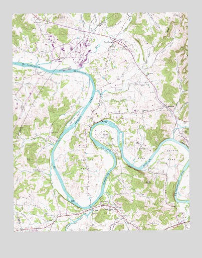
Dixon Springs, TN USGS Topographic Map
Click on map above to begin viewing in our Map Viewer.

This topographic map contains these locations and features:
Feature Name Type Latitude Longitude GNIS ID View Map
Adams ChapelChurchN36.3656°W86.0758°1275464View Map
Alexander IslandIslandN36.3153°W86.0805°1304796View Map
Bartletts BarBarN36.3113°W86.0575°1276405View Map
Beasley CemeteryCemeteryN36.3545°W86.0544°1276680View Map
Beasleys BendBendN36.2887°W86.0750°1305032View Map
Blind IslandIslandN36.2901°W86.0464°1312115View Map
Boston HollowValleyN36.3042°W86.0083°1278018View Map
Bowman BranchStreamN36.3278°W86.0055°1278066View Map
Bradleys CemeteryCemeteryN36.2995°W86.0547°1278194View Map
Bridgewaters LandingLocaleN36.3023°W86.0105°1321089View Map
Brimm HollowValleyN36.3175°W86.0097°1278394View Map
Cage CemeteryCemeteryN36.3003°W86.0372°1279280View Map
Cages BendBendN36.2951°W86.0342°1305589View Map
Cato CemeteryCemeteryN36.2712°W86.0722°1279901View Map
Cedar KnobSummitN36.2914°W86.1122°1280080View Map
Chapel Hill ChurchChurchN36.3178°W86.0330°1280254View Map
Commissioner District 2CivilN36.3217°W86.0117°2463973View Map
Corley BranchStreamN36.3456°W86.1083°1281312View Map
Cotton BarBarN36.3453°W86.1180°1643697View Map
Cox-Davis SchoolSchoolN36.3389°W86.0294°1281514View Map
Davis BranchStreamN36.3173°W86.0108°1282133View Map
Davis CemeteryCemeteryN36.3292°W86.0239°1282161View Map
Dixon CreekStreamN36.3428°W86.0792°1306351View Map
Dixon IslandIslandN36.3434°W86.0847°1282525View Map
Dixon SpringsPopulated PlaceN36.3589°W86.0525°1306354View Map
Dixon Springs Post OfficePost OfficeN36.3593°W86.0524°1651660View Map
Dry BranchStreamN36.3284°W86.0625°1282863View Map
Dry Fork BranchStreamN36.3328°W86.0450°1282972View Map
Duke BranchStreamN36.3428°W86.0342°1283109View Map
Fall CreekStreamN36.2992°W86.0955°1284073View Map
Glasgow BranchStreamN36.3639°W86.0675°1285488View Map
Harper CemeteryCemeteryN36.2550°W86.0417°1286915View Map
Hartsville Nuclear Power PlantLocaleN36.3542°W86.0889°1643698View Map
Haynie PinnaclePillarN36.2776°W86.0314°1287240View Map
Johnson HillSummitN36.3731°W86.0914°1289605View Map
JohntownPopulated PlaceN36.3645°W86.0736°1289675View Map
Kennys BendBendN36.3062°W86.0594°1290087View Map
Kennys CemeteryCemeteryN36.3031°W86.0600°1290088View Map
Kirby CemeteryCemeteryN36.2864°W86.1078°1290284View Map
Knob Spring ChurchChurchN36.3067°W86.0983°1290385View Map
Lick CreekStreamN36.3564°W86.0636°1291220View Map
Litchford CemeteryCemeteryN36.2503°W86.0828°1291364View Map
Litchford CemeteryCemeteryN36.2539°W86.0250°1291365View Map
Lost CreekStreamN36.2820°W86.0572°1292076View Map
Lovells IslandIslandN36.3023°W86.0483°1292147View Map
Maces HillSummitN36.3662°W86.0014°1292431View Map
Maceys Hill CemeteryCemeteryN36.3728°W86.0061°1292433View Map
Manning-Denton CemeteryCemeteryN36.2592°W86.0044°1292590View Map
Mount Olivet ChurchChurchN36.2639°W86.0553°1294729View Map
New Fairview ChurchChurchN36.2662°W86.0633°1295477View Map
Old Lock and Dam Number Seven (historical)DamN36.2881°W86.0311°1321137View Map
Parkers IslandIslandN36.2967°W86.0600°1296840View Map
Paynes BendBendN36.2931°W86.0128°1297023View Map
Peyton CreekStreamN36.3026°W86.0111°1297290View Map
Piper-Hughes CemeteryCemeteryN36.3409°W86.1083°1297693View Map
Plunkett CreekStreamN36.2717°W86.0611°1297988View Map
Plunketts Creek ChurchChurchN36.2589°W86.0472°1297989View Map
Porter CemeteryCemeteryN36.3120°W86.0028°1298257View Map
Rawls CreekStreamN36.2576°W86.0472°1298979View Map
RiddletonPopulated PlaceN36.3214°W86.0180°1299387View Map
Riddleton Baptist ChurchChurchN36.3203°W86.0158°1321140View Map
Riddleton Dixon Springs Volunteer Fire Department District 5BuildingN36.3227°W86.0177°2654624View Map
Riddleton Post OfficePost OfficeN36.3220°W86.0191°1651679View Map
Rock CityPopulated PlaceN36.2631°W86.0530°1299736View Map
Rock City - Rome Fire Department District 4BuildingN36.2634°W86.0548°2654627View Map
Rock HousePopulated PlaceN36.3689°W86.1014°1299771View Map
RomePopulated PlaceN36.2620°W86.0717°1300039View Map
Rome Access AreaParkN36.2609°W86.0708°1321142View Map
Rome Baptist ChurchChurchN36.2603°W86.0747°1321143View Map
Rome Church of ChristChurchN36.2606°W86.0769°1321144View Map
Rome FerryCrossingN36.2639°W86.0705°1312135View Map
Rome IslandIslandN36.2687°W86.0850°1300040View Map
Round Lick CreekStreamN36.2637°W86.0694°1300162View Map
Rowlands TowheadBarN36.2870°W86.0022°1312136View Map
Saltpeter HillSummitN36.3062°W86.0005°1300611View Map
Scraunchers Rock BluffCliffN36.3087°W86.0500°1312137View Map
Stowe CemeteryCemeteryN36.2812°W86.0711°1271561View Map
Sulphur BranchStreamN36.2553°W86.0819°1271769View Map
Taylors BranchStreamN36.2867°W86.0005°1312142View Map
Union Heights Elementary SchoolSchoolN36.2631°W86.0572°1648186View Map
Upton BluffCliffN36.2856°W86.0397°1273313View Map
Violet CemeteryCemeteryN36.2650°W86.0258°1273481View Map
Ward CreekStreamN36.2653°W86.0008°1304372View Map
White BranchStreamN36.2895°W86.0975°1274334View Map
Whites Mill (historical)LocaleN36.2848°W86.1069°1321159View Map
Wilburn CreekStreamN36.3303°W86.0661°1304580View Map
Wilburn HollowValleyN36.3483°W86.0231°1274521View Map
Young BranchStreamN36.3728°W86.0414°1275317View Map

Note: Coordinates in the location and feature list above are referenced to NAD83 datum.


Copyright (C) 2008-2024 Ryan Niemi / Sunset Dynamics ... All Rights Reserved