TopoQuest Logo
Do you find TopoQuest useful?
Help keep TopoQuest running and adding new maps/features by donating!
Bitcoin:  19c7KJd3qBynnjoSw5npx9KScwjBe4ifkT
Litecoin:  LXs6TkuXGGXo1vDsWCkWVdjQX94eUKd6ui
Home View Maps Find Maps Find Places Resources & Links


Minnith, Missouri Topographic Map

USGS Map Title: Minnith, MO
USGS Map MRC: 37090G1
DRG (GeoTIFF) Download: o37090g1.tif


Neighboring USGS Topographic Map Quads:


  Weingarten, MO  
37090H2
 

  Sainte Genevieve, MO  
37090H1
 

  Kaskaskia, IL  
37089H8
 

  Coffman, MO  
37090G2
 

  Minnith, MO  
37090G1
 

  Lithium, MO  
37089G8
 

  Womack, MO  
37090F2
 

  Parker Lake, MO  
37090F1
 

  Perryville West, MO  
37089F8


Map MRC Location:

N38°
W91°
N38°
W90°
H8 H7 H6 H5 H4 H3 H2 H1
G8 G7 G6 G5 G4 G3 G2 G1
F8 F7 F6 F5 F4 F3 F2 F1
E8 E7 E6 E5 E4 E3 E2 E1
D8 D7 D6 D5 D4 D3 D2 D1
C8 C7 C6 C5 C4 C3 C2 C1
B8 B7 B6 B5 B4 B3 B2 B1
A8 A7 A6 A5 A4 A3 A2 A1
N37°
W91°
N37°
W90°

Minnith, MO USGS 1:24K Topographic Map Preview:
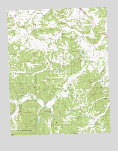
Minnith, MO USGS Topographic Map
Click on map above to begin viewing in our Map Viewer.

This topographic map contains these locations and features:
Feature Name Type Latitude Longitude GNIS ID View Map
Absher Lake DamDamN37.8051°W90.0001°765027View Map
Amos HollowValleyN37.7903°W90.0665°753222View Map
Bald Glade HollowValleyN37.7851°W90.0951°738141View Map
Boarman School (historical)SchoolN37.8395°W90.0640°748948View Map
Bremen SchoolSchoolN37.8659°W90.0343°737655View Map
Brown CemeteryCemeteryN37.8272°W90.0282°742028View Map
Brushy CreekStreamN37.7767°W90.0715°749066View Map
Brushy School (historical)SchoolN37.7553°W90.0646°737656View Map
Cedar Fork SchoolSchoolN37.7581°W90.0159°749293View Map
Cottonwood HollowValleyN37.7928°W90.0651°738140View Map
Curve Trestle HollowValleyN37.7878°W90.1134°753224View Map
Devils Den HollowValleyN37.7595°W90.0748°738137View Map
Donze LakeReservoirN37.8305°W90.0341°758384View Map
Donze Lake DamDamN37.8326°W90.0337°763835View Map
Dry ForkStreamN37.7560°W90.0220°749721View Map
Dry Saline CreekStreamN37.8381°W90.0754°754050View Map
Fish Trap HollowValleyN37.7956°W90.0084°738135View Map
Foerster DamDamN37.7667°W90.0901°764495View Map
Foerster LakeReservoirN37.7643°W90.0897°764496View Map
Giesler Lake DamDamN37.8684°W90.0501°765169View Map
Giesler Lake DamDamN37.8617°W90.0484°764866View Map
Glen Basler Lake DamDamN37.8334°W90.0618°765166View Map
Graveyard HillSummitN37.7623°W90.0662°738138View Map
Hand CemeteryCemeteryN37.7639°W90.0712°742030View Map
High KnollSummitN37.7639°W90.0073°738136View Map
Hudson Lake DamDamN37.7751°W90.0051°765022View Map
Independence SchoolSchoolN37.8287°W90.0179°720096View Map
Johns CreekStreamN37.7784°W90.0807°750520View Map
Kisco DamDamN37.8417°W90.0351°765167View Map
Kisco LakeReservoirN37.8418°W90.0352°765168View Map
Lake Minnie Ha-Ha LowerReservoirN37.8106°W90.0606°764488View Map
Lake Minnie Ha-Ha Lower DamDamN37.8101°W90.0601°764487View Map
Lake Minnie Ha-Ha UpperReservoirN37.8131°W90.0628°764486View Map
Lake Minnie Ha-Ha Upper DamDamN37.8117°W90.0618°764485View Map
Madden CreekStreamN37.7823°W90.1146°750903View Map
Mange CemeteryCemeteryN37.7839°W90.0648°742031View Map
Mill CreekStreamN37.8714°W90.0934°751072View Map
Minnehaha LakeReservoirN37.8117°W90.0621°758385View Map
MinnithPopulated PlaceN37.7981°W90.0501°751123View Map
Opossum HollowValleyN37.8267°W90.0334°738132View Map
OzoraPopulated PlaceN37.8645°W90.0346°751469View Map
Ozora Census Designated PlaceCensusN37.8666°W90.0517°2587100View Map
Ozora Community Fire Protection AssociationBuildingN37.8617°W90.0353°2621244View Map
Ozora Marble QuarriesMineN37.8503°W90.0568°737657View Map
Peaceful Valley CampLocaleN37.8014°W90.0204°742029View Map
Peach Tree RidgeRidgeN37.8545°W90.0759°753219View Map
Pierce HollowValleyN37.7814°W90.0684°738139View Map
Ray HollowValleyN37.7673°W90.0907°753225View Map
Ridgon School (historical)SchoolN37.8370°W90.1129°737654View Map
River aux VasesPopulated PlaceN37.8723°W90.1129°751894View Map
Roth CemeteryCemeteryN37.8325°W90.0128°742027View Map
Sacred Heart Catholic ChurchChurchN37.8653°W90.0343°737658View Map
Saline Baptist ChurchChurchN37.7984°W90.0504°737659View Map
Salt Petre DamDamN37.8301°W90.0818°764483View Map
Salt Petre LakeReservoirN37.8301°W90.0818°764484View Map
Schoolhouse HollowValleyN37.8109°W90.0371°738133View Map
South Fork Saline CreekStreamN37.8212°W90.0001°752260View Map
Swamp HollowValleyN37.7887°W90.1065°753223View Map
Township of BeauvaisCivilN37.8355°W90.0647°767324View Map
Tube BranchStreamN37.8681°W90.0940°738130View Map
Turkey HollowValleyN37.8148°W90.0334°753220View Map
Voelker BranchStreamN37.8012°W90.0109°738134View Map
Voelker CemeteryCemeteryN37.7928°W90.0288°753221View Map
Walnut CreekStreamN37.8584°W90.1126°738142View Map

Note: Coordinates in the location and feature list above are referenced to NAD83 datum.


Copyright (C) 2008-2024 Ryan Niemi / Sunset Dynamics ... All Rights Reserved