TopoQuest Logo
Do you find TopoQuest useful?
Help keep TopoQuest running and adding new maps/features by donating!
Bitcoin:  19c7KJd3qBynnjoSw5npx9KScwjBe4ifkT
Litecoin:  LXs6TkuXGGXo1vDsWCkWVdjQX94eUKd6ui
Home View Maps Find Maps Find Places Resources & Links


Quasqueton, Iowa Topographic Map

USGS Map Title: Quasqueton, IA
USGS Map MRC: 42091D7
DRG (GeoTIFF) Download: o42091d7.tif


Neighboring USGS Topographic Map Quads:


  Hazleton, IA  
42091E8
 

  Oelwein SE, IA  
42091E7
 

  Lamont, IA  
42091E6
 

  Independence, IA  
42091D8
 

  Quasqueton, IA  
42091D7
 

  Winthrop, IA  
42091D6
 

  Cheney, IA  
42091C8
 

  Walker, IA  
42091C7
 

  Troy Mills, IA  
42091C6


Map MRC Location:

N43°
W92°
N43°
W91°
H8 H7 H6 H5 H4 H3 H2 H1
G8 G7 G6 G5 G4 G3 G2 G1
F8 F7 F6 F5 F4 F3 F2 F1
E8 E7 E6 E5 E4 E3 E2 E1
D8 D7 D6 D5 D4 D3 D2 D1
C8 C7 C6 C5 C4 C3 C2 C1
B8 B7 B6 B5 B4 B3 B2 B1
A8 A7 A6 A5 A4 A3 A2 A1
N42°
W92°
N42°
W91°

Quasqueton, IA USGS 1:24K Topographic Map Preview:
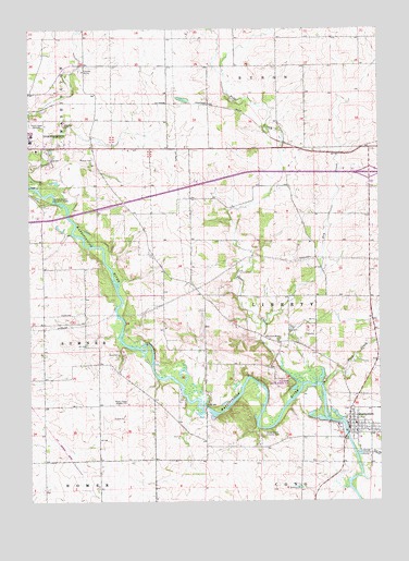
Quasqueton, IA USGS Topographic Map
Click on map above to begin viewing in our Map Viewer.

This topographic map contains these locations and features:
Feature Name Type Latitude Longitude GNIS ID View Map
Ambulance Service Buchanan CountyBuildingN42.4702°W91.8744°2599719View Map
Ben Haven Mobile Home ParkPopulated PlaceN42.3917°W91.7579°2000127View Map
Boies Bend County ParkParkN42.3930°W91.7918°454737View Map
Buchanan CountyCivilN42.4708°W91.8378°465199View Map
Buchanan County HomeBuildingN42.4889°W91.8552°463309View Map
Cedar Rock State ParkParkN42.4061°W91.7704°463769View Map
City of QuasquetonCivilN42.3944°W91.7579°2396297View Map
DorisPopulated PlaceN42.4803°W91.8143°464154View Map
Dry CreekStreamN42.4225°W91.7916°456021View Map
East Buchanan Community SchoolSchoolN42.3955°W91.7588°2000044View Map
East Towne Care CenterHospitalN42.4722°W91.8743°2000086View Map
GatesvillePopulated PlaceN42.4417°W91.8324°464155View Map
Gatesville Post Office (historical)Post OfficeN42.4417°W91.8324°2000065View Map
German Catholic CemeteryCemeteryN42.4750°W91.8724°2000164View Map
Hickory Grove CemeteryCemeteryN42.4207°W91.7534°2000165View Map
KFMN-FM (Waterloo)TowerN42.4011°W91.8435°463755View Map
KFMW-FM (Waterloo)TowerN42.4011°W91.8455°467179View Map
KWWL-TV (Waterloo)TowerN42.4011°W91.8455°467193View Map
Nash CreekStreamN42.4055°W91.7702°459435View Map
Peoples Memorial HospitalHospitalN42.4704°W91.8744°2000087View Map
Pine CreekStreamN42.4069°W91.7779°460163View Map
Pine Creek CemeteryCemeteryN42.4177°W91.7866°2000169View Map
Pine Creek County Wildlife AreaParkN42.4055°W91.7807°2000177View Map
Pine Creek Mission ChurchChurchN42.4175°W91.7863°460166View Map
QuasquetonPopulated PlaceN42.3944°W91.7610°460483View Map
Quasqueton (historical)LocaleN42.3930°W91.7604°2000040View Map
Quasqueton CemeteryCemeteryN42.3990°W91.7622°2000168View Map
Quasqueton Emergency ServicesBuildingN42.3947°W91.7602°2577436View Map
Quasqueton Post OfficePost OfficeN42.3939°W91.7585°2000042View Map
Rowley Fen AreaParkN42.3772°W91.8516°2000047View Map
Taylor's Ford BridgeBridgeN42.4000°W91.8121°2000178View Map
Three Elms County ParkParkN42.4555°W91.8677°462231View Map
Township of LibertyCivilN42.4268°W91.7725°468212View Map
Union Protestant Community ChurchChurchN42.3933°W91.7588°2000043View Map
Veterans Memorial ParkParkN42.3950°W91.7646°2000041View Map
West-Village Care CenterHospitalN42.4722°W91.8743°2000085View Map
Wilson CemeteryCemeteryN42.4656°W91.8520°463102View Map

Note: Coordinates in the location and feature list above are referenced to NAD83 datum.


Copyright (C) 2008-2024 Ryan Niemi / Sunset Dynamics ... All Rights Reserved