TopoQuest Logo
Do you find TopoQuest useful?
Help keep TopoQuest running and adding new maps/features by donating!
Bitcoin:  19c7KJd3qBynnjoSw5npx9KScwjBe4ifkT
Litecoin:  LXs6TkuXGGXo1vDsWCkWVdjQX94eUKd6ui
Home View Maps Find Maps Find Places Resources & Links


Sac City East, Iowa Topographic Map

USGS Map Title: Sac City East, IA
USGS Map MRC: 42094D8
DRG (GeoTIFF) Download: o42094d8.tif


Neighboring USGS Topographic Map Quads:


  Newell West, IA  
42095E1
 

  Newell East, IA  
42094E8
 

  Fonda, IA  
42094E7
 

  Sac City West, IA  
42095D1
 

  Sac City East, IA  
42094D8
 

  Lytton, IA  
42094D7
 

  Lake View, IA  
42095C1
 

  Grant City, IA  
42094C8
 

  Yetter, IA  
42094C7


Map MRC Location:

N43°
W95°
N43°
W94°
H8 H7 H6 H5 H4 H3 H2 H1
G8 G7 G6 G5 G4 G3 G2 G1
F8 F7 F6 F5 F4 F3 F2 F1
E8 E7 E6 E5 E4 E3 E2 E1
D8 D7 D6 D5 D4 D3 D2 D1
C8 C7 C6 C5 C4 C3 C2 C1
B8 B7 B6 B5 B4 B3 B2 B1
A8 A7 A6 A5 A4 A3 A2 A1
N42°
W95°
N42°
W94°

Sac City East, IA USGS 1:24K Topographic Map Preview:
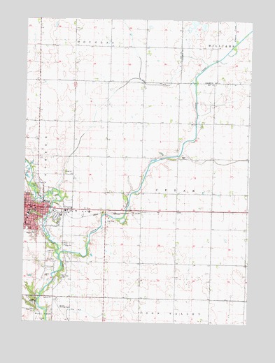
Sac City East, IA USGS Topographic Map
Click on map above to begin viewing in our Map Viewer.

This topographic map contains these locations and features:
Feature Name Type Latitude Longitude GNIS ID View Map
Cedar CemeteryCemeteryN42.4433°W94.9107°1823206View Map
Cedar CreekStreamN42.4022°W94.9803°455228View Map
Chautauqua BuildingBuildingN42.4208°W94.9850°1982934View Map
City of Sac CityCivilN42.4217°W94.9979°2396466View Map
Cory Grove CemeteryCemeteryN42.3933°W94.9791°455642View Map
Early MansionBuildingN42.4225°W94.9914°1982914View Map
East Sac County Middle SchoolSchoolN42.4198°W94.9975°1982930View Map
Faith Bible ChurchChurchN42.4219°W94.9911°1982919View Map
Family Eye Care CenterHospitalN42.4208°W94.9908°1982911View Map
First Baptist ChurchChurchN42.4230°W94.9975°1982922View Map
First Christian ChurchChurchN42.4208°W94.9761°1982918View Map
First Presbyterian ChurchChurchN42.4216°W94.9936°1982920View Map
Hagge County ParkParkN42.3825°W94.9950°463873View Map
Jackson Number Seven School (historical)SchoolN42.4225°W94.9997°1982915View Map
Lions ParkParkN42.4272°W94.9905°1982931View Map
Loring HospitalHospitalN42.4188°W94.9793°1982926View Map
Oakland CemeteryCemeteryN42.4272°W94.9914°459761View Map
Oakland CemeteryCemeteryN42.4316°W94.9928°459762View Map
Park View Care CenterHospitalN42.4208°W94.9775°1982927View Map
Prairie CreekStreamN42.4903°W94.8842°460401View Map
Sac CityPopulated PlaceN42.4222°W94.9897°460882View Map
Sac City (historical)LocaleN42.4244°W94.9892°1982917View Map
Sac City AccessLocaleN42.4069°W94.9803°1982878View Map
Sac City Community BuildingBuildingN42.4214°W94.9875°1982905View Map
Sac City Fire DepartmentBuildingN42.4213°W94.9877°1982904View Map
Sac City LibraryBuildingN42.4222°W94.9955°1982908View Map
Sac City Municipal AirportAirportN42.3841°W94.9807°466933View Map
Sac City ParkParkN42.4208°W94.9850°1982933View Map
Sac City Police DepartmentBuildingN42.4227°W94.9878°1982906View Map
Sac City Post OfficePost OfficeN42.4208°W94.9905°1982910View Map
Sac Community Recreation CenterBuildingN42.4222°W94.9961°1982907View Map
Sac Country ClubLocaleN42.4114°W94.9947°1823204View Map
Sac County Ambulance ServiceBuildingN42.4187°W94.9787°2599965View Map
Sac County CourthouseBuildingN42.4225°W94.9880°1982912View Map
Sac County FairgroundsLocaleN42.4180°W94.9808°1982909View Map
Sac County Historical MuseumBuildingN42.4225°W94.9997°1982916View Map
Sac County Sheriff's OfficeBuildingN42.4227°W94.9877°1982913View Map
Saint Marys Catholic ChurchChurchN42.4153°W94.9994°1982923View Map
Saint Pauls Lutheran ChurchChurchN42.4175°W94.9980°1982924View Map
Schoharie Post Office (historical)Post OfficeN42.4930°W94.9919°1982886View Map
Soldier MonumentParkN42.4219°W94.9878°1982903View Map
South ParkParkN42.4133°W94.9983°1823205View Map
Tolan FieldParkN42.4208°W94.9811°1982932View Map
Township of CedarCivilN42.4296°W94.9152°467563View Map
Trimark Physicians Group BuildingHospitalN42.4186°W94.9794°1982928View Map
United Methodist ChurchChurchN42.4225°W94.9944°1982921View Map

Note: Coordinates in the location and feature list above are referenced to NAD83 datum.


Copyright (C) 2008-2024 Ryan Niemi / Sunset Dynamics ... All Rights Reserved