TopoQuest Logo
Do you find TopoQuest useful?
Help keep TopoQuest running and adding new maps/features by donating!
Bitcoin:  19c7KJd3qBynnjoSw5npx9KScwjBe4ifkT
Litecoin:  LXs6TkuXGGXo1vDsWCkWVdjQX94eUKd6ui
Home View Maps Find Maps Find Places Resources & Links


Saint Lawrence, New York Topographic Map

USGS Map Title: Saint Lawrence, NY
USGS Map MRC: 44076B2
DRG (GeoTIFF) Download: o44076b2.tif


Neighboring USGS Topographic Map Quads:


  Gananoque, ON  
44076C2
 

  Thousand Island Park, NY  
44076C1
 

  Cape Vincent North, NY  
44076B3
 

  Saint Lawrence, NY  
44076B2
 

  Clayton, NY  
44076B1
 

  Cape Vincent South, NY  
44076A3
 

  Chaumont, NY  
44076A2
 

  Dexter, NY  
44076A1


Map MRC Location:

N45°
W77°
N45°
W76°
H8 H7 H6 H5 H4 H3 H2 H1
G8 G7 G6 G5 G4 G3 G2 G1
F8 F7 F6 F5 F4 F3 F2 F1
E8 E7 E6 E5 E4 E3 E2 E1
D8 D7 D6 D5 D4 D3 D2 D1
C8 C7 C6 C5 C4 C3 C2 C1
B8 B7 B6 B5 B4 B3 B2 B1
A8 A7 A6 A5 A4 A3 A2 A1
N44°
W77°
N44°
W76°

Saint Lawrence, NY USGS 1:24K Topographic Map Preview:
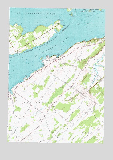
Saint Lawrence, NY USGS Topographic Map
Click on map above to begin viewing in our Map Viewer.

This topographic map contains these locations and features:
Feature Name Type Latitude Longitude GNIS ID View Map
Beadle PointCapeN44.1870°W76.2258°943234View Map
Blanket IslandIslandN44.2359°W76.1497°944229View Map
Blanket ShoalsBarN44.2378°W76.1605°973913View Map
Burnt RockSummitN44.1378°W76.1877°945271View Map
Cape Vincent Correctional FacilityBuildingN44.1979°W76.1882°2756179View Map
Cedar PointCapeN44.2064°W76.1986°946130View Map
Cedar Point State ParkParkN44.2031°W76.1952°946132View Map
Club IslandIslandN44.2478°W76.1422°946935View Map
Cummings PointCapeN44.2484°W76.1308°947935View Map
Dodge BayBayN44.1817°W76.2333°973919View Map
Frontenac SpringsSpringN44.2045°W76.1416°950759View Map
Gull RockBarN44.2425°W76.1497°973325View Map
Gull RockIslandN44.2459°W76.1469°973914View Map
Gull Rock Island (historical)IslandN44.2425°W76.1497°2353066View Map
Gull Rock LightLocaleN44.2425°W76.1497°951941View Map
Lazy Acres Mobile Home ParkPopulated PlaceN44.1783°W76.2386°2618250View Map
Linda IslandIslandN44.2034°W76.2069°974230View Map
Merry Knoll CampgroundLocaleN44.2208°W76.1283°2615223View Map
Millen BayBayN44.1718°W76.2457°957292View Map
Millen BayPopulated PlaceN44.1692°W76.2438°957293View Map
Millen Bay MarinaLocaleN44.2450°W76.1716°973918View Map
Millen Bay Yacht ClubLocaleN44.2448°W76.1708°973917View Map
Papoose IslandIslandN44.2473°W76.1491°959839View Map
Rock WestIslandN44.2352°W76.1611°962740View Map
Rock West Island (historical)IslandN44.2353°W76.1611°2353067View Map
Rose BayBayN44.1703°W76.2244°973920View Map
Saint LawrencePopulated PlaceN44.1773°W76.1677°963803View Map
Saint Lawrence CemeteryCemeteryN44.1591°W76.1948°963805View Map
Sand BayBayN44.1972°W76.2062°964362View Map
Sand Bay CemeteryCemeteryN44.1923°W76.2075°964363View Map
Sawmill BayBayN44.2058°W76.1857°964525View Map
School Number 11 (historical)SchoolN44.1325°W76.1892°2353070View Map
School Number 14 (historical)SchoolN44.1931°W76.2039°2353071View Map
School Number 15 (historical)SchoolN44.1431°W76.1653°2353072View Map
School Number 17 (historical)SchoolN44.1472°W76.2339°2353073View Map
School Number 19 (historical)SchoolN44.1675°W76.1467°2353074View Map
School Number 3 (historical)SchoolN44.1256°W76.2344°2353068View Map
School Number 6 (historical)SchoolN44.1503°W76.2017°2353069View Map
Sperrys FallsFallsN44.1838°W76.1305°2787093View Map
WarrenPopulated PlaceN44.1498°W76.2016°973202View Map
Wheeler CreekStreamN44.2042°W76.1858°971003View Map
Whiskey IslandIslandN44.2473°W76.1530°971054View Map
Wood FarmsLocaleN44.1875°W76.1936°2702863View Map

Note: Coordinates in the location and feature list above are referenced to NAD83 datum.


Copyright (C) 2008-2024 Ryan Niemi / Sunset Dynamics ... All Rights Reserved