TopoQuest Logo
Do you find TopoQuest useful?
Help keep TopoQuest running and adding new maps/features by donating!
Bitcoin:  19c7KJd3qBynnjoSw5npx9KScwjBe4ifkT
Litecoin:  LXs6TkuXGGXo1vDsWCkWVdjQX94eUKd6ui
Home View Maps Find Maps Find Places Resources & Links


Clayton, New York Topographic Map

USGS Map Title: Clayton, NY
USGS Map MRC: 44076B1
DRG (GeoTIFF) Download: o44076b1.tif


Neighboring USGS Topographic Map Quads:


  Gananoque, ON  
44076C2
 

  Thousand Island Park, NY  
44076C1
 

  Alexandria Bay, NY  
44075C8
 

  Saint Lawrence, NY  
44076B2
 

  Clayton, NY  
44076B1
 

  La Fargeville, NY  
44075B8
 

  Chaumont, NY  
44076A2
 

  Dexter, NY  
44076A1
 

  Brownville, NY  
44075A8


Map MRC Location:

N45°
W77°
N45°
W76°
H8 H7 H6 H5 H4 H3 H2 H1
G8 G7 G6 G5 G4 G3 G2 G1
F8 F7 F6 F5 F4 F3 F2 F1
E8 E7 E6 E5 E4 E3 E2 E1
D8 D7 D6 D5 D4 D3 D2 D1
C8 C7 C6 C5 C4 C3 C2 C1
B8 B7 B6 B5 B4 B3 B2 B1
A8 A7 A6 A5 A4 A3 A2 A1
N44°
W77°
N44°
W76°

Clayton, NY USGS 1:24K Topographic Map Preview:
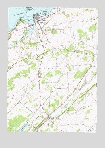
Clayton, NY USGS Topographic Map
Click on map above to begin viewing in our Map Viewer.

This topographic map contains these locations and features:
Feature Name Type Latitude Longitude GNIS ID View Map
American Handweaving MuseumBuildingN44.2408°W76.0871°2617499View Map
Antique Boat MuseumBuildingN44.2380°W76.0892°2617501View Map
Barrett CreekStreamN44.2287°W76.0891°969841View Map
Bartlett PointCapeN44.2384°W76.1080°943102View Map
Black CreekStreamN44.2312°W76.0416°944124View Map
Buttermilk CreekStreamN44.1251°W76.0824°945361View Map
C - Way Golf ClubLocaleN44.2038°W76.0799°2615357View Map
Calumet Island MarinaLocaleN44.2492°W76.0944°973923View Map
Calumet ShoalBarN44.2470°W76.1011°973921View Map
Carrier BayBayN44.2444°W76.0669°945901View Map
Catfish FallsFallsN44.1394°W76.0676°2786733View Map
Central SchoolSchoolN44.2350°W76.0808°946318View Map
Christ Episcopal ChurchChurchN44.2417°W76.0872°2367968View Map
ClaytonPopulated PlaceN44.2395°W76.0858°946809View Map
Clayton CasinoBuildingN44.2372°W76.0892°2367969View Map
Clayton CenterPopulated PlaceN44.1917°W76.0422°972323View Map
Clayton Country ClubLocaleN44.2360°W76.0749°2615371View Map
Clayton Fire DepartmentBuildingN44.2396°W76.0842°2718380View Map
Clayton Police DepartmentBuildingN44.2397°W76.0844°2780363View Map
Clayton Town HallBuildingN44.2425°W76.0867°2367966View Map
Clayton United Methodist ChurchChurchN44.2404°W76.0867°2615786View Map
Clayton Village HallBuildingN44.2398°W76.0844°2617597View Map
Clayton Volunteer Fire DepartmentBuildingN44.2342°W76.0769°2718228View Map
Clayton Yacht ClubLocaleN44.2381°W76.1058°973922View Map
Corbin CemeteryCemeteryN44.1531°W76.0754°947430View Map
DepauvillePopulated PlaceN44.1384°W76.0655°948332View Map
Depauville Census Designated PlaceCensusN44.1424°W76.0451°2389403View Map
Depauville Free LibraryBuildingN44.1363°W76.0721°2617255View Map
Depauville Post OfficePost OfficeN44.1392°W76.0665°2617887View Map
Depauville Sewage Treatment PlantLocaleN44.1367°W76.0725°2617718View Map
Depauville Volunteer Fire DepartmentBuildingN44.1386°W76.0665°2718505View Map
Dutch CemeteryCemeteryN44.1629°W76.0082°948848View Map
Elm FlatsFlatN44.1678°W76.0505°949542View Map
First Baptist ChurchChurchN44.2392°W76.0847°2367972View Map
Fox HillSummitN44.2070°W76.0149°950566View Map
French CreekStreamN44.2234°W76.0961°950690View Map
French Creek BayBayN44.2372°W76.0960°950691View Map
French Creek MarinaLocaleN44.2317°W76.0861°973924View Map
French Creek MarinaHarborN44.2313°W76.0863°2615024View Map
Goose BayBayN44.2411°W76.0779°951348View Map
Governors IslandIslandN44.2470°W76.0980°951427View Map
Hawn Memorial LibraryBuildingN44.2417°W76.0881°2617301View Map
Herald HouseBuildingN44.2428°W76.0864°2367967View Map
Lawrence View Mobile Home ParkPopulated PlaceN44.2439°W76.0631°2618249View Map
Lucky Star LakeReservoirN44.1295°W76.1016°956136View Map
Lucky Star RanchLocaleN44.1294°W76.1117°2702806View Map
McCarn CreekStreamN44.2228°W76.0833°979949View Map
McCarn HillSummitN44.2209°W76.0691°979948View Map
New Life Christian ChurchChurchN44.1398°W76.0670°2616122View Map
Ritchie AirfieldAirportN44.1867°W76.0774°2443558View Map
Riverside Acres CampgroundLocaleN44.2265°W76.1167°2615232View Map
Saint Mary's Roman Catholic ChurchChurchN44.2386°W76.0861°2367971View Map
Saint Mary's Roman Catholic SchoolSchoolN44.2389°W76.0858°2367970View Map
Schnauber HillSummitN44.2028°W76.0049°964589View Map
School Number 10 (historical)SchoolN44.1611°W76.0386°2105942View Map
School Number 14 (historical)SchoolN44.2133°W76.0647°2105943View Map
School Number 2 (historical)SchoolN44.1561°W76.1097°2105939View Map
School Number 7 (historical)SchoolN44.1753°W76.0811°2105940View Map
School Number 9 (historical)SchoolN44.1647°W76.0633°2105941View Map
Smith CornersLocaleN44.1803°W76.0813°965473View Map
Steele PointCapeN44.2437°W76.0727°966328View Map
Thousand Island MarinaLocaleN44.2364°W76.0899°973728View Map
Thousand Islands Emergency Rescue ServiceBuildingN44.2402°W76.0803°2720103View Map
Town of ClaytonCivilN44.2000°W76.0803°978836View Map
Village of ClaytonCivilN44.2370°W76.0826°2391609View Map
Washington IslandIslandN44.2456°W76.0777°968852View Map
Weaver CemeteryCemeteryN44.1532°W76.1085°968962View Map
Wendall HallBuildingN44.2414°W76.0875°2367965View Map

Note: Coordinates in the location and feature list above are referenced to NAD83 datum.


Copyright (C) 2008-2024 Ryan Niemi / Sunset Dynamics ... All Rights Reserved