TopoQuest Logo
Do you find TopoQuest useful?
Help keep TopoQuest running and adding new maps/features by donating!
Bitcoin:  19c7KJd3qBynnjoSw5npx9KScwjBe4ifkT
Litecoin:  LXs6TkuXGGXo1vDsWCkWVdjQX94eUKd6ui
Home View Maps Find Maps Find Places Resources & Links


Strafford, Missouri Topographic Map

USGS Map Title: Strafford, MO
USGS Map MRC: 37093C1
DRG (GeoTIFF) Download: o37093c1.tif


Neighboring USGS Topographic Map Quads:


  Fair Grove, MO  
37093D2
 

  Elkland, MO  
37093D1
 

  Beach, MO  
37092D8
 

  Bassville, MO  
37093C2
 

  Strafford, MO  
37093C1
 

  Marshfield, MO  
37092C8
 

  Galloway, MO  
37093B2
 

  Oak Grove Heights, MO  
37093B1
 

  Fordland, MO  
37092B8


Map MRC Location:

N38°
W94°
N38°
W93°
H8 H7 H6 H5 H4 H3 H2 H1
G8 G7 G6 G5 G4 G3 G2 G1
F8 F7 F6 F5 F4 F3 F2 F1
E8 E7 E6 E5 E4 E3 E2 E1
D8 D7 D6 D5 D4 D3 D2 D1
C8 C7 C6 C5 C4 C3 C2 C1
B8 B7 B6 B5 B4 B3 B2 B1
A8 A7 A6 A5 A4 A3 A2 A1
N37°
W94°
N37°
W93°

Strafford, MO USGS 1:24K Topographic Map Preview:
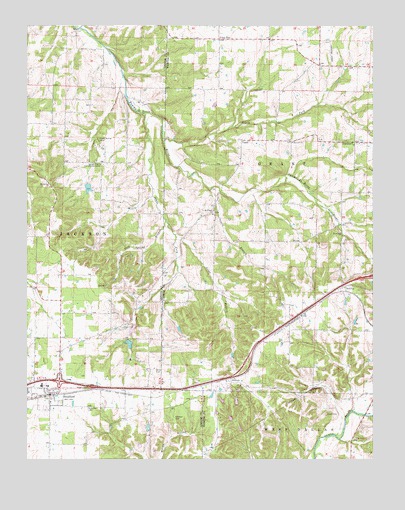
Strafford, MO USGS Topographic Map
Click on map above to begin viewing in our Map Viewer.

This topographic map contains these locations and features:
Feature Name Type Latitude Longitude GNIS ID View Map
Bodenhammer School (historical)SchoolN37.3417°W93.0488°742318View Map
Bumgarner CemeteryCemeteryN37.3375°W93.0002°715032View Map
CaddoPopulated PlaceN37.3420°W93.0471°715176View Map
Caldwell CemeteryCemeteryN37.2620°W93.0718°715189View Map
Circle Lake DamDamN37.2700°W93.0485°763547View Map
City of StraffordCivilN37.2689°W93.1207°2395981View Map
Cross WayPopulated PlaceN37.3714°W93.0557°740782View Map
Elk Lake DamDamN37.2650°W93.0552°763352View Map
Epworth ChurchChurchN37.3412°W93.0291°717620View Map
Fellowship ChurchChurchN37.3406°W93.0071°717881View Map
Goss SchoolSchoolN37.3134°W93.0488°742317View Map
Great Bear Lake DamDamN37.2584°W93.0468°764771View Map
Grier BranchStreamN37.3148°W93.0716°718874View Map
Happy Hollow CampLocaleN37.3420°W93.0993°719071View Map
Hardeke LakeReservoirN37.3282°W93.1031°763798View Map
Hardeke Lake DamDamN37.3284°W93.1035°763797View Map
Hilliard Estates LakeReservoirN37.3184°W93.1218°763367View Map
Hilliard Estates Lake DamDamN37.3184°W93.1218°763366View Map
HolmanPopulated PlaceN37.2731°W93.0532°740936View Map
Holman School (historical)LocaleN37.2725°W93.0488°742316View Map
Jarrett BranchStreamN37.3275°W93.0591°720262View Map
Jones LakeReservoirN37.2589°W93.0481°764772View Map
KTOZ-FM (Marshfield)TowerN37.2992°W93.0074°754251View Map
Lake Ralph Foster DamDamN37.2650°W93.0485°763353View Map
Locust Prairie Community CenterLocaleN37.3350°W93.0974°721397View Map
Locust Prairie SchoolSchoolN37.3350°W93.0977°742319View Map
Lost Lake DamDamN37.2617°W93.0502°763315View Map
Mount Calvary ChurchChurchN37.3284°W93.1166°722719View Map
Mount Pisgah ChurchChurchN37.3206°W93.0580°722844View Map
Mueller LakeReservoirN37.2873°W93.0872°763314View Map
Mueller Lake DamDamN37.2884°W93.0868°763313View Map
Mullinax CemeteryCemeteryN37.2648°W93.1032°723060View Map
North Carolina CreekStreamN37.2503°W93.0213°723436View Map
North Fork Pomme de Terre RiverStreamN37.3425°W93.0760°723466View Map
North View HillSummitN37.3023°W93.0063°738283View Map
Polk Spring BranchStreamN37.3189°W93.0749°724715View Map
Red TopPopulated PlaceN37.2998°W93.0105°736339View Map
Salisbury LakeReservoirN37.2833°W93.0881°762935View Map
Salisbury Lake DamDamN37.2850°W93.0885°762934View Map
South Fork Pomme de Terre RiverStreamN37.3503°W93.0857°726751View Map
StraffordPopulated PlaceN37.2684°W93.1171°727168View Map
Strafford Fire Protection District Station 1BuildingN37.2857°W93.1216°2621110View Map
Strafford Fire Protection District Station 3BuildingN37.2693°W93.1168°2621624View Map
Strafford Fire Protection District Station 4BuildingN37.3192°W93.0637°2620712View Map
Strafford Police DepartmentBuildingN37.2692°W93.1169°2752461View Map
Strafford Post OfficePost OfficeN37.2689°W93.1189°2782637View Map
Township of GrantCivilN37.3365°W93.0208°767529View Map
Township of Jackson Number 2CivilN37.2866°W93.1196°766686View Map
Welch CemeteryCemeteryN37.2628°W93.0171°728483View Map
Willis CemeteryCemeteryN37.2759°W93.0788°728911View Map

Note: Coordinates in the location and feature list above are referenced to NAD83 datum.


Copyright (C) 2008-2024 Ryan Niemi / Sunset Dynamics ... All Rights Reserved