TopoQuest Logo
Do you find TopoQuest useful?
Help keep TopoQuest running and adding new maps/features by donating!
Bitcoin:  19c7KJd3qBynnjoSw5npx9KScwjBe4ifkT
Litecoin:  LXs6TkuXGGXo1vDsWCkWVdjQX94eUKd6ui
Home View Maps Find Maps Find Places Resources & Links


Beach, Missouri Topographic Map

USGS Map Title: Beach, MO
USGS Map MRC: 37092D8
DRG (GeoTIFF) Download: o37092d8.tif


Neighboring USGS Topographic Map Quads:


  Charity, MO  
37093E1
 

  Long Lane, MO  
37092E8
 

  Phillipsburg, MO  
37092E7
 

  Elkland, MO  
37093D1
 

  Beach, MO  
37092D8
 

  Niangua, MO  
37092D7
 

  Strafford, MO  
37093C1
 

  Marshfield, MO  
37092C8
 

  High Prairie, MO  
37092C7


Map MRC Location:

N38°
W93°
N38°
W92°
H8 H7 H6 H5 H4 H3 H2 H1
G8 G7 G6 G5 G4 G3 G2 G1
F8 F7 F6 F5 F4 F3 F2 F1
E8 E7 E6 E5 E4 E3 E2 E1
D8 D7 D6 D5 D4 D3 D2 D1
C8 C7 C6 C5 C4 C3 C2 C1
B8 B7 B6 B5 B4 B3 B2 B1
A8 A7 A6 A5 A4 A3 A2 A1
N37°
W93°
N37°
W92°

Beach, MO USGS 1:24K Topographic Map Preview:
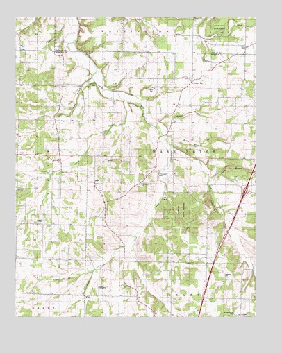
Beach, MO USGS Topographic Map
Click on map above to begin viewing in our Map Viewer.

This topographic map contains these locations and features:
Feature Name Type Latitude Longitude GNIS ID View Map
Antioch Church (historical)ChurchN37.4839°W92.9766°734956View Map
BeachPopulated PlaceN37.4312°W92.9591°735502View Map
Beckner FieldAirportN37.3862°W92.9581°758805View Map
Bethel Church (historical)ChurchN37.4742°W92.9082°734957View Map
Callaway BluffCliffN37.4200°W92.8977°738224View Map
DermottPopulated PlaceN37.3834°W92.9374°734959View Map
East Fork Niangua RiverStreamN37.4462°W92.9196°717296View Map
Forkners HillPopulated PlaceN37.4728°W92.9091°718103View Map
Full Gospel ChurchChurchN37.4278°W92.9996°742179View Map
Givins BranchStreamN37.4642°W92.9418°718475View Map
Goose CreekStreamN37.4909°W92.9021°736013View Map
Graves SchoolSchoolN37.4917°W92.9266°718753View Map
Greer CreekStreamN37.4045°W92.9402°738221View Map
Hagan BranchStreamN37.4553°W92.9293°738229View Map
Hawk Pond BranchStreamN37.4742°W92.9602°719227View Map
Haymes ChapelChurchN37.4139°W92.9882°742178View Map
Hollis BranchStreamN37.4503°W92.9235°738225View Map
Independence SchoolSchoolN37.4717°W92.9893°720095View Map
Jameson BluffCliffN37.4714°W92.9585°738227View Map
Jameson SchoolSchoolN37.3839°W92.9410°720253View Map
Lutheran CemeteryCemeteryN37.3753°W92.8824°743401View Map
Marlin BranchStreamN37.4689°W92.9477°738226View Map
Marlin CemeteryCemeteryN37.4700°W92.9302°721888View Map
Marlin School (historical)SchoolN37.4670°W92.9363°721890View Map
McElwain CemeteryCemeteryN37.3928°W92.8916°722097View Map
Mill BluffCliffN37.4242°W92.9232°738222View Map
Miller SchoolSchoolN37.4137°W92.9899°722385View Map
Mission Home ChurchChurchN37.3878°W92.9421°722466View Map
Pack SchoolSchoolN37.4628°W92.8852°723950View Map
Plank School (historical)SchoolN37.3820°W92.8824°734960View Map
Saint LukeLocaleN37.4292°W92.9377°754150View Map
Saint Luke ChurchChurchN37.4306°W92.9355°725817View Map
Saint Luke School (historical)SchoolN37.4312°W92.9355°734958View Map
Sand Spring SchoolSchoolN37.3850°W92.9916°726022View Map
Sarah BranchStreamN37.4339°W92.9005°738228View Map
Shady Grove ChurchChurchN37.4431°W92.9896°726241View Map
Shady Grove School (historical)SchoolN37.4423°W92.9899°734961View Map
Sparkle Brook SchoolSchoolN37.4189°W92.8913°726828View Map
Thompson BluffCliffN37.4345°W92.9266°738223View Map
ThorpePopulated PlaceN37.4878°W92.9979°727623View Map
Township of WashingtonCivilN37.4247°W92.9251°767536View Map
Warden ChapelChurchN37.4873°W92.8802°728345View Map
West Fork Niangua RiverStreamN37.4462°W92.9193°728571View Map

Note: Coordinates in the location and feature list above are referenced to NAD83 datum.


Copyright (C) 2008-2024 Ryan Niemi / Sunset Dynamics ... All Rights Reserved