TopoQuest Logo
Do you find TopoQuest useful?
Help keep TopoQuest running and adding new maps/features by donating!
Bitcoin:  19c7KJd3qBynnjoSw5npx9KScwjBe4ifkT
Litecoin:  LXs6TkuXGGXo1vDsWCkWVdjQX94eUKd6ui
Home View Maps Find Maps Find Places Resources & Links


Swan Lake NW, Mississippi Topographic Map

USGS Map Title: Swan Lake NW, MS
USGS Map MRC: 33090B8
DRG (GeoTIFF) Download: o33090b8.tif


Neighboring USGS Topographic Map Quads:


  Wayside, MS  
33091C1
 

  Arcola, MS  
33090C8
 

  Tribbett, MS  
33090C7
 

  Avon, MS  
33091B1
 

  Swan Lake NW, MS  
33090B8
 

  Hollandale, MS  
33090B7
 

  Glen Allan, MS  
33091A1
 

  Percy, MS  
33090A8
 

  Delta City, MS  
33090A7


Map MRC Location:

N34°
W91°
N34°
W90°
H8 H7 H6 H5 H4 H3 H2 H1
G8 G7 G6 G5 G4 G3 G2 G1
F8 F7 F6 F5 F4 F3 F2 F1
E8 E7 E6 E5 E4 E3 E2 E1
D8 D7 D6 D5 D4 D3 D2 D1
C8 C7 C6 C5 C4 C3 C2 C1
B8 B7 B6 B5 B4 B3 B2 B1
A8 A7 A6 A5 A4 A3 A2 A1
N33°
W91°
N33°
W90°

Swan Lake NW, MS USGS 1:24K Topographic Map Preview:
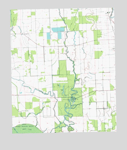
Swan Lake NW, MS USGS Topographic Map
Click on map above to begin viewing in our Map Viewer.

This topographic map contains these locations and features:
Feature Name Type Latitude Longitude GNIS ID View Map
Albert Prevost Catfish Pond DamDamN33.2168°W90.9168°681927View Map
Albert Prevost Pond DamDamN33.1451°W90.9684°681875View Map
Alder Grove (historical)Populated PlaceN33.1937°W90.9098°687150View Map
Bell Catfish Ponds DamDamN33.1335°W90.9301°681868View Map
Brushy LakeLakeN33.1679°W90.9378°667702View Map
Farm Fresh Catfish Ponds DamDamN33.2201°W90.9534°681932View Map
Farm Fresh Catfish Ponds DamDamN33.2218°W90.9384°681937View Map
Farm Fresh Catfish Ponds DamDamN33.2285°W90.9384°681943View Map
Forrest City (historical)Populated PlaceN33.1929°W90.9251°687205View Map
Gamble LakeLakeN33.1726°W90.9423°670307View Map
Granicus BayouStreamN33.1337°W90.9423°670586View Map
Leroy Percy Game Management AreaParkN33.1501°W90.9293°687245View Map
Leroy Percy State ParkParkN33.1607°W90.9323°672407View Map
Macedonia CemeteryCemeteryN33.2451°W90.8815°672988View Map
McCutcheonPopulated PlaceN33.2346°W90.8798°687251View Map
Moon LakeBasinN33.1285°W90.9307°673759View Map
Mount Tabor ChurchChurchN33.2121°W90.9409°674280View Map
MuskedinePopulated PlaceN33.2246°W90.9837°692092View Map
Prevost Catfish Ponds DamDamN33.2285°W90.9184°681942View Map
Puzzle BayouStreamN33.1796°W90.9229°676427View Map
Spraggins Lake DamDamN33.2085°W90.9468°681917View Map
Strangers Home ChurchChurchN33.1568°W90.9537°678337View Map
Swan LakeSwampN33.1254°W90.9793°678452View Map

Note: Coordinates in the location and feature list above are referenced to NAD83 datum.


Copyright (C) 2008-2024 Ryan Niemi / Sunset Dynamics ... All Rights Reserved