TopoQuest Logo
Do you find TopoQuest useful?
Help keep TopoQuest running and adding new maps/features by donating!
Bitcoin:  19c7KJd3qBynnjoSw5npx9KScwjBe4ifkT
Litecoin:  LXs6TkuXGGXo1vDsWCkWVdjQX94eUKd6ui
Home View Maps Find Maps Find Places Resources & Links


Tribbett, Mississippi Topographic Map

USGS Map Title: Tribbett, MS
USGS Map MRC: 33090C7
DRG (GeoTIFF) Download: o33090c7.tif


Neighboring USGS Topographic Map Quads:


  Leland, MS  
33090D8
 

  Holly Ridge, MS  
33090D7
 

  Indianola, MS  
33090D6
 

  Arcola, MS  
33090C8
 

  Tribbett, MS  
33090C7
 

  Kinlock, MS  
33090C6
 

  Swan Lake NW, MS  
33090B8
 

  Hollandale, MS  
33090B7
 

  Midnight NW, MS  
33090B6


Map MRC Location:

N34°
W91°
N34°
W90°
H8 H7 H6 H5 H4 H3 H2 H1
G8 G7 G6 G5 G4 G3 G2 G1
F8 F7 F6 F5 F4 F3 F2 F1
E8 E7 E6 E5 E4 E3 E2 E1
D8 D7 D6 D5 D4 D3 D2 D1
C8 C7 C6 C5 C4 C3 C2 C1
B8 B7 B6 B5 B4 B3 B2 B1
A8 A7 A6 A5 A4 A3 A2 A1
N33°
W91°
N33°
W90°

Tribbett, MS USGS 1:24K Topographic Map Preview:
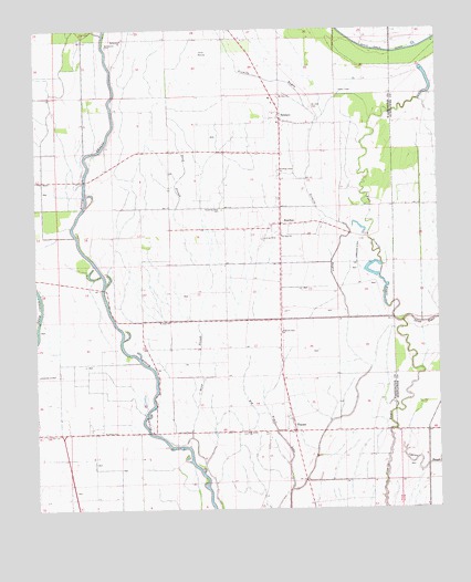
Tribbett, MS USGS Topographic Map
Click on map above to begin viewing in our Map Viewer.

This topographic map contains these locations and features:
Feature Name Type Latitude Longitude GNIS ID View Map
Bear LakeStreamN33.3737°W90.8534°666660View Map
Bethlehem CemeteryCemeteryN33.3707°W90.8523°666981View Map
Bethlehem ChurchChurchN33.3723°W90.8473°667009View Map
Big Trail LakeStreamN33.2551°W90.7968°667156View Map
BourbonPopulated PlaceN33.3243°W90.7987°667466View Map
Brown Lake DamDamN33.3535°W90.7701°682012View Map
East Sixmile BayouStreamN33.2996°W90.7645°669610View Map
J M Dean PondDamN33.3151°W90.7684°681988View Map
Kindling Altar CemeteryCemeteryN33.3282°W90.8170°672135View Map
Kindling Altar ChurchChurchN33.3385°W90.7990°672136View Map
King Solomon ChurchChurchN33.2704°W90.8673°687236View Map
ManhattanPopulated PlaceN33.2718°W90.8573°687249View Map
McGrathPopulated PlaceN33.2896°W90.7982°711133View Map
Mount Avery ChurchChurchN33.2698°W90.8098°673926View Map
Mount Zion CemeteryCemeteryN33.3548°W90.7890°674319View Map
Mount Zion ChurchChurchN33.3576°W90.7990°674382View Map
New TownPopulated PlaceN33.2710°W90.7534°686568View Map
OsseolaPopulated PlaceN33.3060°W90.8726°687279View Map
Pilgrims Rest ChurchChurchN33.2962°W90.7987°675775View Map
Randolph (historical)Populated PlaceN33.3385°W90.8520°687293View Map
Saint James ChurchChurchN33.2701°W90.8504°677040View Map
Saint John ChurchChurchN33.2990°W90.8334°677060View Map
Saint Paul ChurchChurchN33.3212°W90.7982°677197View Map
TralakePopulated PlaceN33.2704°W90.7948°678853View Map
TribbettPopulated PlaceN33.3515°W90.7984°678871View Map

Note: Coordinates in the location and feature list above are referenced to NAD83 datum.


Copyright (C) 2008-2024 Ryan Niemi / Sunset Dynamics ... All Rights Reserved