TopoQuest Logo
Do you find TopoQuest useful?
Help keep TopoQuest running and adding new maps/features by donating!
Bitcoin:  19c7KJd3qBynnjoSw5npx9KScwjBe4ifkT
Litecoin:  LXs6TkuXGGXo1vDsWCkWVdjQX94eUKd6ui
Home View Maps Find Maps Find Places Resources & Links


Trezevant West, Tennessee Topographic Map

USGS Map Title: Trezevant West, TN
USGS Map MRC: 36088A6
DRG (GeoTIFF) Download: o36088a6.tif


Neighboring USGS Topographic Map Quads:


  Greenfield, TN  
36088B7
 

  Pillowville, TN  
36088B6
 

  McKenzie, TN  
36088B5
 

  Bradford, TN  
36088A7
 

  Trezevant West, TN  
36088A6
 

  Trezevant East, TN  
36088A5
 

  Milan, TN  
35088H7
 

  Atwood, TN  
35088H6
 

  McLemoresville, TN  
35088H5


Map MRC Location:

N37°
W89°
N37°
W88°
H8 H7 H6 H5 H4 H3 H2 H1
G8 G7 G6 G5 G4 G3 G2 G1
F8 F7 F6 F5 F4 F3 F2 F1
E8 E7 E6 E5 E4 E3 E2 E1
D8 D7 D6 D5 D4 D3 D2 D1
C8 C7 C6 C5 C4 C3 C2 C1
B8 B7 B6 B5 B4 B3 B2 B1
A8 A7 A6 A5 A4 A3 A2 A1
N36°
W89°
N36°
W88°

Trezevant West, TN USGS 1:24K Topographic Map Preview:
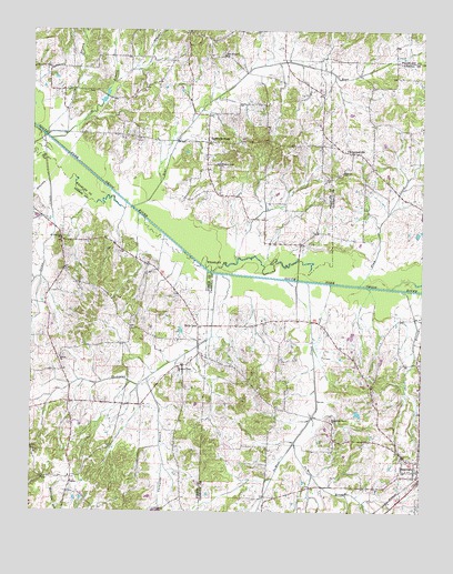
Trezevant West, TN USGS Topographic Map
Click on map above to begin viewing in our Map Viewer.

This topographic map contains these locations and features:
Feature Name Type Latitude Longitude GNIS ID View Map
Austin Hank LakeReservoirN36.0017°W88.7101°1302290View Map
Austin Hank Lake DamDamN36.0017°W88.7101°1302291View Map
Bear CreekStreamN36.0790°W88.7178°1276582View Map
Belews Chapel CemeteryCemeteryN36.0403°W88.7398°1322049View Map
Belews ChurchChurchN36.0401°W88.7412°1305075View Map
Brock CemeteryCemeteryN36.0964°W88.7164°1645136View Map
Cane BranchStreamN36.0965°W88.7442°1279499View Map
ChristmasvillePopulated PlaceN36.0934°W88.6476°1280534View Map
DeMoss BranchStreamN36.0181°W88.6656°1282237View Map
DeMoss CreekStreamN36.0598°W88.6617°1282238View Map
Dinwiddie Store (historical)LocaleN36.0973°W88.7164°1322291View Map
District 15 (historical)CivilN36.0084°W88.7376°1310202View Map
District 2 (historical)CivilN36.0017°W88.6334°1325875View Map
District 3 (historical)CivilN36.1001°W88.6292°1325876View Map
Dolan CreekStreamN36.0978°W88.7470°1282617View Map
Flippen School (historical)SchoolN36.0153°W88.7037°1322103View Map
GannPopulated PlaceN36.0087°W88.7370°1285130View Map
Gann School (historical)SchoolN36.0092°W88.7376°1322105View Map
Gibson County Fire Department Station 4 GannBuildingN36.0092°W88.7389°2653839View Map
Holly LeafPopulated PlaceN36.0484°W88.6967°1315251View Map
Holt School (historical)SchoolN36.1126°W88.7081°1322342View Map
Mount Aries School (historical)SchoolN36.0965°W88.6789°1322381View Map
Mount Pleasant CemeteryCemeteryN36.0678°W88.7398°1322168View Map
Mount Pleasant ChurchChurchN36.0706°W88.7409°1294772View Map
Mount Zion Church of Christ (historical)ChurchN36.0398°W88.7403°1322172View Map
New Prospect CemeteryCemeteryN36.1192°W88.6889°1322393View Map
New Prospect ChurchChurchN36.1187°W88.6889°1295620View Map
Oak Grove School (historical)SchoolN36.0342°W88.6423°1320358View Map
Oak Hill School (historical)SchoolN36.0473°W88.7181°1322186View Map
Pilgrims ChurchChurchN36.0881°W88.6509°1306895View Map
Pilgrims Rest CemeteryCemeteryN36.0876°W88.6523°1326676View Map
Pittman BranchStreamN36.0973°W88.7456°1297747View Map
Pittman CemeteryCemeteryN36.1089°W88.7323°1322420View Map
Pittman School (historical)SchoolN36.1090°W88.7339°1322419View Map
Pleasant Green CemeteryCemeteryN36.0384°W88.6992°1322196View Map
Pleasant Green ChurchChurchN36.0373°W88.7028°1297795View Map
Pleasant Grove Baptist ChurchChurchN36.0901°W88.6906°1297825View Map
Pleasant Grove CemeteryCemeteryN36.0898°W88.6906°1322421View Map
Plum CreekStreamN36.0590°W88.6451°1297972View Map
Pratt CemeteryCemeteryN36.0166°W88.7499°1298466View Map
Pratt ChurchChurchN36.0162°W88.7498°1298468View Map
Republican Grove Missionary Baptist ChurchChurchN36.0240°W88.6539°1299226View Map
Short BranchStreamN36.0578°W88.6317°1270177View Map
Smiths Chapel School (historical)SchoolN36.0515°W88.7445°1322220View Map
Staffords StorePopulated PlaceN36.0962°W88.6942°1303783View Map
Thompson BranchStreamN36.0351°W88.7123°1272509View Map
Thompson CreekStreamN36.0617°W88.6909°1272539View Map

Note: Coordinates in the location and feature list above are referenced to NAD83 datum.


Copyright (C) 2008-2024 Ryan Niemi / Sunset Dynamics ... All Rights Reserved