TopoQuest Logo
Do you find TopoQuest useful?
Help keep TopoQuest running and adding new maps/features by donating!
Bitcoin:  19c7KJd3qBynnjoSw5npx9KScwjBe4ifkT
Litecoin:  LXs6TkuXGGXo1vDsWCkWVdjQX94eUKd6ui
Home View Maps Find Maps Find Places Resources & Links


McKenzie, Tennessee Topographic Map

USGS Map Title: McKenzie, TN
USGS Map MRC: 36088B5
DRG (GeoTIFF) Download: o36088b5.tif


Neighboring USGS Topographic Map Quads:


  Dresden, TN  
36088C6
 

  Como, TN  
36088C5
 

  Osage, TN  
36088C4
 

  Pillowville, TN  
36088B6
 

  McKenzie, TN  
36088B5
 

  Henry, TN  
36088B4
 

  Trezevant West, TN  
36088A6
 

  Trezevant East, TN  
36088A5
 

  Huntingdon, TN  
36088A4


Map MRC Location:

N37°
W89°
N37°
W88°
H8 H7 H6 H5 H4 H3 H2 H1
G8 G7 G6 G5 G4 G3 G2 G1
F8 F7 F6 F5 F4 F3 F2 F1
E8 E7 E6 E5 E4 E3 E2 E1
D8 D7 D6 D5 D4 D3 D2 D1
C8 C7 C6 C5 C4 C3 C2 C1
B8 B7 B6 B5 B4 B3 B2 B1
A8 A7 A6 A5 A4 A3 A2 A1
N36°
W89°
N36°
W88°

McKenzie, TN USGS 1:24K Topographic Map Preview:
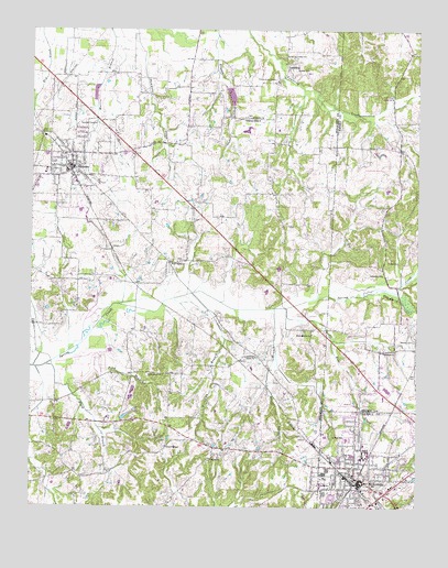
McKenzie, TN USGS Topographic Map
Click on map above to begin viewing in our Map Viewer.

This topographic map contains these locations and features:
Feature Name Type Latitude Longitude GNIS ID View Map
Bethel CollegeSchoolN36.1392°W88.5164°1305154View Map
Bible Mission ChurchChurchN36.1703°W88.5339°1277214View Map
Boaz CreekStreamN36.1773°W88.5420°1277857View Map
Bond BranchStreamN36.1726°W88.6028°1277929View Map
Booth BranchStreamN36.1620°W88.6192°1277990View Map
Butler CemeteryCemeteryN36.2392°W88.5395°1279180View Map
Caldenoia CemeteryCemeteryN36.1659°W88.5067°1326003View Map
Caledonia ChurchChurchN36.1659°W88.5076°1326798View Map
Caledonia CreekStreamN36.1806°W88.5173°1279320View Map
Christian ChapelChurchN36.2262°W88.5512°1280523View Map
City of McKenzieCivilN36.1380°W88.5083°2405052View Map
Coldwater ChurchChurchN36.1859°W88.5114°1280912View Map
Commissioner District 2CivilN36.1794°W88.6027°2463985View Map
Community Grove ChurchChurchN36.1645°W88.5553°1281047View Map
Crawley CemeteryCemeteryN36.2062°W88.5120°1326021View Map
East Grove School (historical)SchoolN36.2012°W88.5603°1322306View Map
El Bethel CemeteryCemeteryN36.2273°W88.5550°1322309View Map
El Bethel CemeteryCemeteryN36.2259°W88.5134°1326031View Map
El Bethel ChurchChurchN36.2270°W88.5539°1283586View Map
Everett ChapelChurchN36.1409°W88.5809°1283919View Map
Everett Chapel CemeteryCemeteryN36.1409°W88.5814°1322311View Map
Fairview School (historical)SchoolN36.1356°W88.5709°1322313View Map
First United Methodist ChurchChurchN36.1340°W88.5214°1646034View Map
Fodge CemeteryCemeteryN36.1898°W88.5078°1284545View Map
GleasonPopulated PlaceN36.2137°W88.6126°1303460View Map
Gleason City HallBuildingN36.2123°W88.6106°1322322View Map
Gleason Division (historical)CensusN36.1984°W88.5973°1649011View Map
Gleason First Baptist ChurchChurchN36.2123°W88.6098°1322323View Map
Gleason Police DepartmentBuildingN36.2132°W88.6115°2765978View Map
Gleason Post OfficePost OfficeN36.2144°W88.6117°1651885View Map
Gleason SchoolSchoolN36.2128°W88.6134°1322324View Map
Gleason Volunteer Fire DepartmentBuildingN36.2135°W88.6107°2653642View Map
Glisson CemeteryCemeteryN36.2373°W88.5028°1326039View Map
Grace Baptist ChurchChurchN36.1356°W88.5295°1320325View Map
Green Hill School (historical)SchoolN36.1337°W88.6176°1322325View Map
GreenhillsPopulated PlaceN36.1328°W88.6173°1326733View Map
Hastings Store (historical)LocaleN36.2187°W88.5059°1317326View Map
Huggins ParkParkN36.2131°W88.6173°1322343View Map
Jones CemeteryCemeteryN36.1648°W88.5131°1326052View Map
Lawrence CemeteryCemeteryN36.2342°W88.5037°1326059View Map
Manley CemeteryCemeteryN36.1687°W88.5059°1292577View Map
Masonic Male and Female Institute (historical)SchoolN36.2134°W88.6139°1322370View Map
McKenziePopulated PlaceN36.1326°W88.5187°1326832View Map
McKenzie Church of ChristChurchN36.1328°W88.5031°1646043View Map
McKenzie Cumberland Presbyterian ChurchChurchN36.1331°W88.5203°1646044View Map
McKenzie Division (historical)CensusN36.1256°W88.5131°1648630View Map
McKenzie Fire DepartmentBuildingN36.1330°W88.5192°2653668View Map
McKenzie First Baptist ChurchChurchN36.1337°W88.5203°1320347View Map
McKenzie High SchoolSchoolN36.1384°W88.5209°1320348View Map
McKenzie Junior High SchoolSchoolN36.1426°W88.5228°1320349View Map
McKenzie Police DepartmentBuildingN36.1333°W88.5195°2765907View Map
McKenzie Primitive Baptist ChurchChurchN36.1381°W88.5206°1646045View Map
Middle Fork Obion Dam ElevenDamN36.2351°W88.5617°1302434View Map
Middle Fork Obion LakeReservoirN36.2328°W88.5607°1302435View Map
Miller CemeteryCemeteryN36.1937°W88.5125°1326074View Map
New Valley CemeteryCemeteryN36.1895°W88.5773°1322394View Map
New Valley ChurchChurchN36.1892°W88.5776°1295663View Map
Old El Bethel CemeteryCemeteryN36.2287°W88.5209°1326095View Map
Page CemeteryCemeteryN36.2409°W88.5853°1322406View Map
Roney CemeteryCemeteryN36.1987°W88.5417°1322432View Map
Salem CemeteryCemeteryN36.1370°W88.5673°1322436View Map
Salem ChurchChurchN36.1376°W88.5662°1300563View Map
Salem School (historical)SchoolN36.1398°W88.5662°1322437View Map
Smyth CemeteryCemeteryN36.2148°W88.6112°1322452View Map
Spring Creek BranchStreamN36.1770°W88.5462°1271092View Map
Success School (historical)SchoolN36.2067°W88.5053°1317422View Map
Town of GleasonCivilN36.2174°W88.6107°2406572View Map
TumblingPopulated PlaceN36.2412°W88.5426°1326772View Map
Tumbling Creek Baptist ChurchChurchN36.2414°W88.5434°1322465View Map
Tumbling Creek CemeteryCemeteryN36.2428°W88.5439°1272972View Map
Tumbling School (historical)SchoolN36.2373°W88.5464°1322466View Map
Tyson CemeteryCemeteryN36.2306°W88.5212°1326146View Map
Union CemeteryCemeteryN36.2331°W88.5092°1326147View Map
Union ChurchChurchN36.2320°W88.5087°1273207View Map
Union Grove ChurchChurchN36.1598°W88.5817°1304242View Map
Union Grove School (historical)SchoolN36.1601°W88.5828°1322468View Map
Webb SchoolSchoolN36.1312°W88.5309°1274040View Map
Williams Store (historical)LocaleN36.1381°W88.6148°1322487View Map
Wilson CemeteryCemeteryN36.2009°W88.5095°1326158View Map
WKTA-FM (McKenzie)TowerN36.1273°W88.5095°1640100View Map
Wrinkley BranchStreamN36.1809°W88.5728°1275193View Map

Note: Coordinates in the location and feature list above are referenced to NAD83 datum.


Copyright (C) 2008-2024 Ryan Niemi / Sunset Dynamics ... All Rights Reserved