TopoQuest Logo
Do you find TopoQuest useful?
Help keep TopoQuest running and adding new maps/features by donating!
Bitcoin:  19c7KJd3qBynnjoSw5npx9KScwjBe4ifkT
Litecoin:  LXs6TkuXGGXo1vDsWCkWVdjQX94eUKd6ui
Home View Maps Find Maps Find Places Resources & Links


Union Hill, Tennessee Topographic Map

USGS Map Title: Union Hill, TN
USGS Map MRC: 36085E6
DRG (GeoTIFF) Download: o36085e6.tif


Neighboring USGS Topographic Map Quads:


  Gamaliel, KY  
36085F7
 

  Tompkinsville, KY  
36085F6
 

  Vernon, KY  
36085F5
 

  Red Boiling Springs, TN  
36085E7
 

  Union Hill, TN  
36085E6
 

  Celina, TN  
36085E5
 

  Willette, TN  
36085D7
 

  Whitleyville, TN  
36085D6
 

  Burristown, TN  
36085D5


Map MRC Location:

N37°
W86°
N37°
W85°
H8 H7 H6 H5 H4 H3 H2 H1
G8 G7 G6 G5 G4 G3 G2 G1
F8 F7 F6 F5 F4 F3 F2 F1
E8 E7 E6 E5 E4 E3 E2 E1
D8 D7 D6 D5 D4 D3 D2 D1
C8 C7 C6 C5 C4 C3 C2 C1
B8 B7 B6 B5 B4 B3 B2 B1
A8 A7 A6 A5 A4 A3 A2 A1
N36°
W86°
N36°
W85°

Union Hill, TN USGS 1:24K Topographic Map Preview:
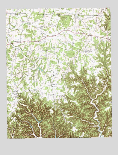
Union Hill, TN USGS Topographic Map
Click on map above to begin viewing in our Map Viewer.

This topographic map contains these locations and features:
Feature Name Type Latitude Longitude GNIS ID View Map
Bird HollowValleyN36.5156°W85.7120°1645138View Map
BolesPopulated PlaceN36.6187°W85.6644°507543View Map
BolesPopulated PlaceN36.6184°W85.6655°1277900View Map
Brannon CreekStreamN36.5006°W85.7086°1278235View Map
Brays KnobSummitN36.6159°W85.6816°1278258View Map
Brimestone School (historical)SchoolN36.5092°W85.6405°1321787View Map
Brimstone ChurchChurchN36.5089°W85.6400°1305421View Map
Campground ChurchChurchN36.6073°W85.7089°1321792View Map
Cherry CrossroadsPopulated PlaceN36.5931°W85.7325°1314827View Map
ClementsvillePopulated PlaceN36.6117°W85.7258°1314856View Map
Clementsville Church of ChristChurchN36.6112°W85.7258°1321802View Map
Commissioner District 1CivilN36.5646°W85.6295°2464219View Map
Commissioner District 2CivilN36.5665°W85.7482°2463907View Map
Cove CreekStreamN36.5559°W85.7400°1304741View Map
Denton CrossroadsPopulated PlaceN36.5837°W85.6550°1647828View Map
Eminence School (historical)SchoolN36.6039°W85.6514°1321806View Map
Hermitage Springs Division (historical)CensusN36.5551°W85.7161°1652459View Map
Hurricane CreekStreamN36.6084°W85.7169°1288800View Map
Jennings Creek Watershed Dam Number FiveDamN36.5151°W85.7133°1302659View Map
Jennings Creek Watershed Dam Number SixDamN36.5101°W85.7216°1302655View Map
Jonestown CemeteryCemeteryN36.5620°W85.6922°1289828View Map
Lake Number FiveReservoirN36.5156°W85.7125°1302658View Map
Lake Number SixReservoirN36.5101°W85.7216°1302654View Map
Laurel Bluff School (historical)SchoolN36.6051°W85.7464°1321821View Map
Left Fork Brimstone CreekStreamN36.5362°W85.6483°1290988View Map
Line Creek Lake Number Three BReservoirN36.5669°W85.7107°1302680View Map
Line Creek Watershed Dam Number Three BDamN36.5684°W85.7116°1302681View Map
Little Brimstone CreekStreamN36.5103°W85.6411°1291399View Map
McCormick RidgeRidgeN36.5176°W85.6814°1312439View Map
Miles CemeteryCemeteryN36.5437°W85.7402°1293775View Map
Miles CrossroadsPopulated PlaceN36.5426°W85.7386°1293777View Map
Milestown Church of ChristChurchN36.5403°W85.7386°1321827View Map
Moss Volunteer Fire DepartmentBuildingN36.5936°W85.6261°2654880View Map
Mount Vernon Charity TabernacleChurchN36.5459°W85.7366°1321831View Map
Mount Vernon ChurchChurchN36.5459°W85.7380°1294833View Map
Mount Vernon SchoolSchoolN36.5403°W85.7383°1294836View Map
Mount Vernon Volunteer Fire Department Red Boiling SpringsBuildingN36.5425°W85.7391°2654651View Map
Oak GrovePopulated PlaceN36.5970°W85.7033°1296062View Map
Oak Grove Church of ChristChurchN36.5973°W85.7036°1321838View Map
Oak Grove School (historical)SchoolN36.5989°W85.7025°1321839View Map
Pide BranchStreamN36.5042°W85.6375°1297409View Map
Pine HillPopulated PlaceN36.5684°W85.6464°1297545View Map
Pine Hill Church of ChristChurchN36.5687°W85.6450°1321843View Map
Pine Hill School (historical)SchoolN36.5678°W85.6450°1321844View Map
Pitcock CemeteryCemeteryN36.5992°W85.6911°1297735View Map
Ridge Top FarmLocaleN36.5344°W85.7178°2635252View Map
Right Fork Brannon CreekStreamN36.5156°W85.7119°1299428View Map
Right Fork Brimstone CreekStreamN36.5364°W85.6480°1299429View Map
Running Late Poultry FarmLocaleN36.5256°W85.6789°2635244View Map
Smith's Poultry FarmsLocaleN36.5400°W85.6983°2635249View Map
Sweetwater CreekStreamN36.6216°W85.6781°504855View Map
Union HillPopulated PlaceN36.5514°W85.6961°1304248View Map
Union Hill CemeteryCemeteryN36.5545°W85.6952°1321863View Map
Union Hill Church of ChristChurchN36.5542°W85.6964°1321864View Map
Union Hill Community CenterBuildingN36.5539°W85.6955°1321865View Map
Union Hill School (historical)SchoolN36.5539°W85.6955°1321866View Map
Wesleyan ChurchChurchN36.5278°W85.6858°1274126View Map

Note: Coordinates in the location and feature list above are referenced to NAD83 datum.


Copyright (C) 2008-2024 Ryan Niemi / Sunset Dynamics ... All Rights Reserved