TopoQuest Logo
Do you find TopoQuest useful?
Help keep TopoQuest running and adding new maps/features by donating!
Bitcoin:  19c7KJd3qBynnjoSw5npx9KScwjBe4ifkT
Litecoin:  LXs6TkuXGGXo1vDsWCkWVdjQX94eUKd6ui
Home View Maps Find Maps Find Places Resources & Links


Vail Lake, California Topographic Map

USGS Map Title: Vail Lake, CA
USGS Map MRC: 33116D8
DRG (GeoTIFF) Download: o33116d8.tif


Neighboring USGS Topographic Map Quads:


  Bachelor Mountain, CA  
33117E1
 

  Sage, CA  
33116E8
 

  Cahuilla Mountain, CA  
33116E7
 

  Pechanga, CA  
33117D1
 

  Vail Lake, CA  
33116D8
 

  Aguanga, CA  
33116D7
 

  Pala, CA  
33117C1
 

  Boucher Hill, CA  
33116C8
 

  Palomar Observatory, CA  
33116C7


Map MRC Location:

N34°
W117°
N34°
W116°
H8 H7 H6 H5 H4 H3 H2 H1
G8 G7 G6 G5 G4 G3 G2 G1
F8 F7 F6 F5 F4 F3 F2 F1
E8 E7 E6 E5 E4 E3 E2 E1
D8 D7 D6 D5 D4 D3 D2 D1
C8 C7 C6 C5 C4 C3 C2 C1
B8 B7 B6 B5 B4 B3 B2 B1
A8 A7 A6 A5 A4 A3 A2 A1
N33°
W117°
N33°
W116°

Vail Lake, CA USGS 1:24K Topographic Map Preview:
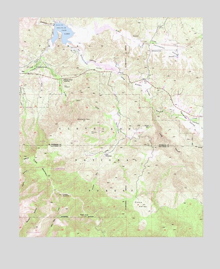
Vail Lake, CA USGS Topographic Map
Click on map above to begin viewing in our Map Viewer.

This topographic map contains these locations and features:
Feature Name Type Latitude Longitude GNIS ID View Map
Agua Tibia MountainSummitN33.4098°W116.9820°238453View Map
Agua Tibia WildernessReserveN33.4226°W116.9798°2035036View Map
Aguanga ValleyValleyN33.4411°W116.8856°269450View Map
Arroyo Seco CreekStreamN33.4842°W116.9778°238772View Map
Butterfield County Recreational Vehicle ParkLocaleN33.4792°W116.9939°1849527View Map
Butterfield Lake EstatesPopulated PlaceN33.4800°W116.9634°1849528View Map
Butterfield ValleyValleyN33.4842°W116.9620°255390View Map
Cottonwood CreekStreamN33.4445°W116.8945°240979View Map
Cottonwood K-8 SchoolSchoolN33.4804°W116.9106°240993View Map
Crosley HomesteadLocaleN33.4209°W116.9420°241117View Map
Crosley SaddleGapN33.3995°W116.9717°241118View Map
Crosley Truck TrailTrailN33.4181°W116.9522°241119View Map
Crossbar Oaks CampgroundLocaleN33.4745°W116.9870°1849533View Map
Cutca ValleyValleyN33.3992°W116.9172°241179View Map
Cutca Valley Truck TrailTrailN33.4164°W116.9153°241180View Map
Devils HoleValleyN33.4469°W116.9378°241468View Map
Dripping SpringsSpringN33.4722°W116.9890°241620View Map
Dripping Springs CampgroundLocaleN33.4609°W116.9709°2548694View Map
Dripping Springs Guard StationLocaleN33.4642°W116.9709°241621View Map
Dripping Springs TrailTrailN33.4378°W116.9742°274868View Map
Dripping Springs TrailheadLocaleN33.4581°W116.9708°2548696View Map
Eagle CrageSummitN33.3873°W116.9561°241704View Map
Kolb CreekStreamN33.4753°W116.9831°244360View Map
Lancaster ValleyValleyN33.4853°W116.9119°244562View Map
Long CanyonValleyN33.4461°W116.9075°245065View Map
Ormsby CampgroundLocaleN33.4759°W116.9870°1849546View Map
Palomar Mesa CampgroundLocaleN33.4723°W116.9861°1849549View Map
RadecPopulated PlaceN33.4642°W116.9139°252960View Map
Radec ValleyValleyN33.4592°W116.9225°247908View Map
Rancho California Lake ClubLocaleN33.4848°W116.9686°1849553View Map
Rincon Mesa CampgroundLocaleN33.4773°W116.9872°1849557View Map
Riverside County Fire Department Station 52 CottonwoodBuildingN33.4817°W116.9114°2664942View Map
Sawyer SpringSpringN33.4378°W116.9125°249190View Map
Spring CreekStreamN33.4936°W116.9489°1701425View Map
United States Forest Service Cleveland National Forest Station - Dripping SpringsBuildingN33.4642°W116.9707°2548695View Map
Vail 2028 DamDamN33.4959°W116.9767°1664081View Map
Vail LakeReservoirN33.4905°W116.9705°250880View Map
Vail Lake Boat LaunchLocaleN33.4809°W116.9613°2548732View Map
Wild Horse PeakSummitN33.4417°W116.9572°251535View Map
Wilson CreekStreamN33.4909°W116.9625°251680View Map
Wilson ValleyValleyN33.4899°W116.8762°274543View Map

Note: Coordinates in the location and feature list above are referenced to NAD83 datum.


Copyright (C) 2008-2024 Ryan Niemi / Sunset Dynamics ... All Rights Reserved