TopoQuest Logo
Do you find TopoQuest useful?
Help keep TopoQuest running and adding new maps/features by donating!
Bitcoin:  19c7KJd3qBynnjoSw5npx9KScwjBe4ifkT
Litecoin:  LXs6TkuXGGXo1vDsWCkWVdjQX94eUKd6ui
Home View Maps Find Maps Find Places Resources & Links


Boucher Hill, California Topographic Map

USGS Map Title: Boucher Hill, CA
USGS Map MRC: 33116C8
DRG (GeoTIFF) Download: o33116c8.tif


Neighboring USGS Topographic Map Quads:


  Pechanga, CA  
33117D1
 

  Vail Lake, CA  
33116D8
 

  Aguanga, CA  
33116D7
 

  Pala, CA  
33117C1
 

  Boucher Hill, CA  
33116C8
 

  Palomar Observatory, CA  
33116C7
 

  Valley Center, CA  
33117B1
 

  Rodriguez Mountain, CA  
33116B8
 

  Mesa Grande, CA  
33116B7


Map MRC Location:

N34°
W117°
N34°
W116°
H8 H7 H6 H5 H4 H3 H2 H1
G8 G7 G6 G5 G4 G3 G2 G1
F8 F7 F6 F5 F4 F3 F2 F1
E8 E7 E6 E5 E4 E3 E2 E1
D8 D7 D6 D5 D4 D3 D2 D1
C8 C7 C6 C5 C4 C3 C2 C1
B8 B7 B6 B5 B4 B3 B2 B1
A8 A7 A6 A5 A4 A3 A2 A1
N33°
W117°
N33°
W116°

Boucher Hill, CA USGS 1:24K Topographic Map Preview:
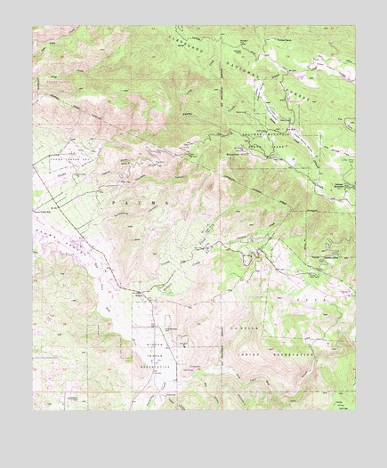
Boucher Hill, CA USGS Topographic Map
Click on map above to begin viewing in our Map Viewer.

This topographic map contains these locations and features:
Feature Name Type Latitude Longitude GNIS ID View Map
Adams TrailTrailN33.3395°W116.9170°1868438View Map
Baptist CampLocaleN33.3467°W116.9172°269670View Map
Baptist TrailTrailN33.3431°W116.9136°1868440View Map
Bee CanyonValleyN33.2603°W116.9384°269779View Map
Boucher HillSummitN33.3348°W116.9189°269977View Map
Boucher LookoutLocaleN33.3348°W116.9197°1868360View Map
Boucher TrailTrailN33.3356°W116.9214°1868361View Map
CAL FIRE Rincon StationBuildingN33.2885°W116.9615°2664768View Map
Cedar Grove CampgroundLocaleN33.3398°W116.9114°1868454View Map
Cedar TrailTrailN33.3403°W116.9061°1868455View Map
Chimney FlatsFlatN33.3295°W116.8834°1868363View Map
Clark MineMineN33.2628°W116.9386°270488View Map
CucaCivilN33.2842°W116.8914°270700View Map
Doane CreekStreamN33.3489°W116.9120°270881View Map
Doane PondReservoirN33.3401°W116.9014°1868464View Map
Doane ValleyValleyN33.3492°W116.9125°277203View Map
Doane Valley CampgroundLocaleN33.3439°W116.9014°1868465View Map
Doane Valley Natural PreserveParkN33.3492°W116.9111°1868466View Map
Doane Valley Natural PreserveReserveN33.3492°W116.9083°2741197View Map
Doane Valley Nature TrailTrailN33.3445°W116.9064°1868467View Map
Doane Valley ReservoirReservoirN33.3295°W116.8872°1868468View Map
French CreekStreamN33.3489°W116.9120°271226View Map
French Valley TrailTrailN33.3503°W116.9095°1868477View Map
Friendly Ranch (historical)LocaleN33.3034°W116.9820°1703107View Map
Fry Creek CampgroundLocaleN33.3453°W116.8831°277205View Map
Fry Creek TrailTrailN33.3445°W116.8867°277204View Map
Gomez TrailTrailN33.3628°W116.9478°271352View Map
Gordon PointSummitN33.3664°W116.9192°271368View Map
Happyland SanitariumHospitalN33.2536°W116.9864°1660716View Map
Harrison CanyonValleyN33.3250°W116.9856°252163View Map
Jaybird CreekStreamN33.3245°W116.9847°271777View Map
La Jolla Indian Reservation Volunteer Fire DepartmentBuildingN33.3035°W116.9080°2548709View Map
La Jolla ReservationCivilN33.2644°W116.8756°271928View Map
Lion CreekStreamN33.3450°W116.9422°272056View Map
Lone Fir PointSummitN33.3414°W116.9245°1868400View Map
Lower Doane TrailTrailN33.3470°W116.9067°1868484View Map
Lower Doane ValleyValleyN33.3492°W116.9120°272255View Map
Lower French ValleyValleyN33.3489°W116.9120°272256View Map
Lyall AirportAirportN33.3236°W116.9921°1653437View Map
Mack MineMineN33.2711°W116.9420°272300View Map
Mission TrailTrailN33.3703°W116.9717°272506View Map
Morgan HillSummitN33.3698°W116.9217°1661061View Map
Oak Knoll CampgroundLocaleN33.2936°W116.9022°277206View Map
Observatory CampgroundLocaleN33.3428°W116.8772°2548719View Map
Palomar MountainPopulated PlaceN33.3228°W116.8786°272859View Map
Palomar Mountain State ParkParkN33.3375°W116.9103°272860View Map
Palomar Mountain State Park HeadquartersLocaleN33.3306°W116.9017°1868498View Map
Paradise CreekStreamN33.2636°W116.9547°272871View Map
PaumaCivilN33.3189°W116.9606°272894View Map
Pauma and Yuima ReservationCivilN33.3632°W116.9549°272896View Map
Pauma Indian CemeteryCemeteryN33.3267°W116.9844°272899View Map
Pauma MissionChurchN33.3334°W116.9859°1868411View Map
Pauma Reservation Fire DepartmentBuildingN33.3331°W116.9851°2665021View Map
Pauma ValleyPopulated PlaceN33.3034°W116.9814°1661202View Map
Pauma Valley Country ClubLocaleN33.3011°W116.9875°1654761View Map
Pauma Valley Post OfficePost OfficeN33.3038°W116.9782°1868412View Map
Plaisted CreekStreamN33.3020°W116.9289°273049View Map
Potrero CreekStreamN33.2800°W116.9689°273102View Map
Potrero Indian CemeteryCemeteryN33.2884°W116.8786°1703109View Map
RinconPopulated PlaceN33.2881°W116.9584°273283View Map
Rincon ReservationCivilN33.2637°W116.9562°273286View Map
Saint Bartholomew CemeteryCemeteryN33.2770°W116.9482°273394View Map
Saint Francis Episcopal Church Memorial GardenCemeteryN33.2956°W116.9684°2773344View Map
School CampLocaleN33.3411°W116.8989°1868508View Map
Scotts Cabin TrailTrailN33.3342°W116.9009°1868509View Map
Silver Creek Picnic AreaLocaleN33.3323°W116.9075°1868513View Map
Sunday School FlatsFlatN33.3300°W116.8775°273965View Map
Sycamore CanyonValleyN33.3109°W116.9736°273991View Map
Thunder Spring TrailTrailN33.3353°W116.8964°1868519View Map
Tin Can FlatFlatN33.3303°W116.9522°274144View Map
Upper Doane ValleyValleyN33.3400°W116.9017°274280View Map
Upper Doane Valley TrailTrailN33.3361°W116.8953°1868523View Map
Upper French ValleyValleyN33.3598°W116.8934°274281View Map
Valley of the SpringsValleyN33.2536°W116.8839°274306View Map
Victor MineMineN33.2642°W116.9392°274337View Map
Webber RanchLocaleN33.3706°W116.9056°274406View Map
Weir TrailTrailN33.3448°W116.9092°1868524View Map
Yuima CreekStreamN33.2814°W116.9700°274602View Map
Yuima Reservation (historical)CivilN33.3023°W116.9325°274603View Map

Note: Coordinates in the location and feature list above are referenced to NAD83 datum.


Copyright (C) 2008-2024 Ryan Niemi / Sunset Dynamics ... All Rights Reserved