TopoQuest Logo
Do you find TopoQuest useful?
Help keep TopoQuest running and adding new maps/features by donating!
Bitcoin:  19c7KJd3qBynnjoSw5npx9KScwjBe4ifkT
Litecoin:  LXs6TkuXGGXo1vDsWCkWVdjQX94eUKd6ui
Home View Maps Find Maps Find Places Resources & Links


Verona, Kentucky Topographic Map

USGS Map Title: Verona, KY
USGS Map MRC: 38084G6
DRG (GeoTIFF) Download: o38084g6.tif


Neighboring USGS Topographic Map Quads:


  Rising Sun, IN  
38084H7
 

  Union, KY  
38084H6
 

  Independence, KY  
38084H5
 

  Patriot, IN  
38084G7
 

  Verona, KY  
38084G6
 

  Walton, KY  
38084G5
 

  Glencoe, KY  
38084F7
 

  Elliston, KY  
38084F6
 

  Williamstown, KY  
38084F5


Map MRC Location:

N39°
W85°
N39°
W84°
H8 H7 H6 H5 H4 H3 H2 H1
G8 G7 G6 G5 G4 G3 G2 G1
F8 F7 F6 F5 F4 F3 F2 F1
E8 E7 E6 E5 E4 E3 E2 E1
D8 D7 D6 D5 D4 D3 D2 D1
C8 C7 C6 C5 C4 C3 C2 C1
B8 B7 B6 B5 B4 B3 B2 B1
A8 A7 A6 A5 A4 A3 A2 A1
N38°
W85°
N38°
W84°

Verona, KY USGS 1:24K Topographic Map Preview:
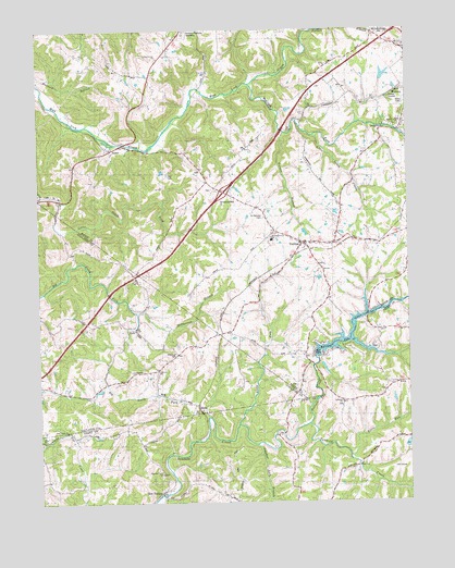
Verona, KY USGS Topographic Map
Click on map above to begin viewing in our Map Viewer.

This topographic map contains these locations and features:
Feature Name Type Latitude Longitude GNIS ID View Map
Beaverlick ChurchChurchN38.8676°W84.7088°486637View Map
Beaverlick Church CemeteryCemeteryN38.8673°W84.7093°2569210View Map
Bullock Pen CreekStreamN38.7706°W84.6588°488379View Map
Bullock Pen LakeReservoirN38.7884°W84.6561°488380View Map
Carr CemeteryCemeteryN38.8364°W84.7058°488971View Map
Chapman CemeteryCemeteryN38.7892°W84.7033°489355View Map
Concord ChurchChurchN38.7845°W84.7097°489940View Map
Crittenden DivisionCivilN38.7550°W84.6452°1936957View Map
Flat Creek ChurchChurchN38.7695°W84.7411°492186View Map
HumePopulated PlaceN38.8440°W84.7236°508295View Map
Hume CemeteryCemeteryN38.8376°W84.6947°2569272View Map
Hume Post Office (historical)Post OfficeN38.8430°W84.7255°2569228View Map
Kittle RunStreamN38.7617°W84.6449°495823View Map
Lebanon ChurchChurchN38.7762°W84.6477°496137View Map
Little Salem CreekStreamN38.8473°W84.6563°496855View Map
McCoys ForkStreamN38.8603°W84.6774°497821View Map
McPherson BranchStreamN38.8003°W84.7172°497943View Map
Mueller Farm AirportAirportN38.8234°W84.6838°2444076View Map
MunkPopulated PlaceN38.7756°W84.6966°508661View Map
New Bethel Church CemeteryCemeteryN38.8129°W84.6543°2569233View Map
North Fork Ten Mile CreekStreamN38.7706°W84.6830°499569View Map
Northern Kentucky SpeedwayParkN38.8743°W84.6997°2569234View Map
Pleasant View ChurchChurchN38.7576°W84.7091°500952View Map
Powers CemeteryCemeteryN38.8328°W84.6911°2569284View Map
Ryan Field Airport (historical)AirportN38.8043°W84.6596°2444095View Map
RylePopulated PlaceN38.7953°W84.7166°508993View Map
Saint Patrick Catholic Church (historical)ChurchN38.8252°W84.6732°2569289View Map
Saints Patricks CemeteryCemeteryN38.8253°W84.6733°502709View Map
Salem Baptist Church (historical)ChurchN38.8503°W84.6287°2569241View Map
Salem Church CemeteryCemeteryN38.8499°W84.6287°2569290View Map
Stephensons Mill (historical)LocaleN38.8509°W84.6621°2569246View Map
Sulphur Lick BranchStreamN38.7653°W84.6766°504741View Map
VeronaPopulated PlaceN38.8184°W84.6608°506026View Map
Verona BranchStreamN38.8476°W84.6661°506027View Map
Verona Census Designated PlaceCensusN38.8122°W84.6649°2629699View Map
Verona Elementary School (historical)SchoolN38.8190°W84.6574°2569248View Map
Verona Fire Protection DistrictBuildingN38.8183°W84.6570°2636852View Map
Verona LandingAirportN38.8169°W84.6722°2444101View Map
Verona Railroad Station (historical)LocaleN38.8153°W84.6632°2569298View Map
Verona Rescue Squad Ambulance ServiceBuildingN38.8183°W84.6570°2719109View Map
Walton DivisionCivilN38.8749°W84.6922°1937305View Map
Zion StationPopulated PlaceN38.7528°W84.7094°507301View Map

Note: Coordinates in the location and feature list above are referenced to NAD83 datum.


Copyright (C) 2008-2024 Ryan Niemi / Sunset Dynamics ... All Rights Reserved